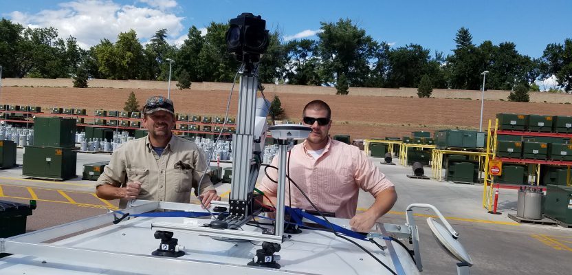
Above: Gary Rust (left) and Anthony Whitlock from Springs Utilities pose with their LiDAR USA HiWay Mapper HD.
The history of a Colorado utility systematically deploying lidar technology reveals lidar’s journey as an asset.
Located at the base of Pikes Peak on the front range of the Colorado Rockies, Colorado Springs Utilities is a city-owned enterprise and the fourth-largest four-service utility in the United States. Originally developed as a municipal water and wastewater system, Springs Utilities added electric and natural gas service in 1924. Springs Utilities serves a population of approximately 380,000, including more than 150,000 homes and businesses.
Much of Springs Utilities’ data management for infrastructure falls on the Asset Management-Geospatial Technologies Department. Within the department, the Land Base Services Group (LBS) provides surveying services for GIS data maintenance, construction/design surveys, as-built conditions surveys, dam-structure monitoring, and easement/real property analysis. To support the organization’s core services, LBS surveyors have used conventional tools such as theodolites, total stations, GPS, field data collectors, and measuring tapes.
Following Springs Utilities’ organizational value of continuous improvement, LBS has steadily deployed advancing 3D laser scanning technology to safely and remotely collect massive amounts of spatial data for water, wastewater, natural gas, and electric operations. Initial capture of comprehensive data reduces site visits and provides a clear desktop picture for remote designers. Detailed and dimensionally precise models are designed to fit to the geo-referenced points for efficient data rendering in CAD environments.
Increasing Lidar’s Use
LBS was an early adopter of lidar and laser technology. Lidar’s benefits were clear, but budgets were tight. In order to move forward with new technology, LBS had to perform due diligence on systems (hardware, software) and present the technology benefits to internal clients. At each stage of the lidar journey, LBS delivered improved products and information. This success prompted internal clients to advocate for continued technology advances.
The following is a reflection on the evolution of laser use by the LBS team. Reference to product brands is not an endorsement by xyHt or Springs Utilities. Our product acquisition is impartial and adheres to strict request-for-proposal and fair-bid evaluation processes.
Early Lasers
Electronic distance measurement (EDM) instruments using lasers became commercially viable for surveyors in the 1970s. It was a groundbreaking technology, but targets were limited to placed “poro prisms” (geometric mirrors). Eventually, reflectorless technology emerged, eliminating the need for target mirrors. Total stations could capture discrete, remote positions at a higher rate from most objects/materials.
In the mid-2000s, Springs Utilities’ electric substation/transmission engineering group sponsored LBS in the acquisition of a Topcon reflectorless total station with the intent to measure electric conductor wire heights and clearances. The technology drastically improved productivity over manual trigonometric techniques for public safety and regulatory compliance projects.
The instrument also provided key distances in substation equipment installations, simple building dimensioning, small-scale stockpile topography, and inaccessible cliff faces. Compared to earlier methods, the technology was very useful, collecting points numbering in the 10s or 100s, but it was task-specific and did not provide a complete contextual picture.
In 2008, LBS acquired a Trimble VX total station with basic, automated scanning functions and image capture. The realized scan rate—approximately 15 points per second—allowed for new data-acquisition possibilities and acted as the bridge to a dedicated scanning platform. Coarse point density proved useful for stockpile volumes and for small, focused areas, such as a single circuit breaker in a substation. The increased point-cloud density made the technology useful for engineering design.
The acquisition of Trimble RealWorks, a dedicated point-cloud processing and modeling software, was very significant. Springs Utilities uses Autodesk products for engineering and design, and RealWorks provided the bridge for LBS to begin delivering useful, basic point clouds to internal clients.
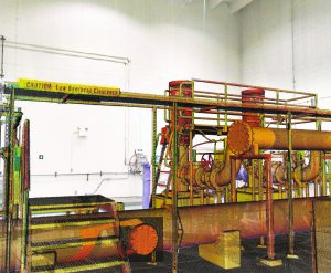
A photo from the Faro during an emergency as-built scan. Modeling was used to fabricate a custom repair coupler.
Dedicated Terrestrial Scanners
The benefits of the data from VX and RealWorks sparked innovation in the engineers and managers across departments. In 2010, Springs Utilities’ electric engineering group funded the first true terrestrial lidar scanner, the Trimble GX, for LBS. By today’s standards, the GX seems archaic but, in 2010, it was chosen for its capabilities versus cost.
With a large external power supply and a scan rate of less than 5,000 points per second, the GX was heavy and hardly portable. However, it was reliable, accurate, and opened a new era in capturing spatial data for Springs Utilities. For two years, LBS literally hauled the GX to diverse job sites. Substation, tower, and conductor projects were carried out for the electric engineering sponsors, and the water and wastewater groups also started to fully use the system.
Projects included larger-scale stockpile inventories at material yards, accurate volumes of empty reservoir basins, and detailed topography of creek crossings where critical infrastructure crosses waterways.
The GX was first used in a plant environment at the Las Vegas Water Resource Recovery Facility. Precise dimensions from scans between two pipe runs were obtained for a cross-connect design. Engineers and welders marveled on the trouble-free field construction; the scanning was eliminating spatial design variables, surprises and cost overruns!
In 2012, with resources from the electric, water, and wastewater groups, LBS acquired a Faro Focus s120 scanner. Compared to the GX, the Faro Focus was one-third the weight and hundreds of times faster with a small on-board power supply. Other options on the market had slightly better ranging accuracies, but the selection process for choosing this model was again a capabilities-versus-cost consideration.
The speed, portability, and durability of the Faro Focus lifted Springs Utilities’ lidar project capabilities to another level. LBS acquired a second Faro Focus, the x330 with a longer range and eye-safe laser, in 2016. With the Faro scanners, LBS expanded the scanning project work with faster turn-around times.
Advances in the RealWorks software nearly eliminated the need for targets in scan-to-scan registration. Simple modeling for topography or generalized representations of structures is done in-house with RealWorks and Autodesk tools. Approved contractors carried out complex modeling, such as plant-wide equipment renderings.
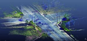
This point cloud from a Faro static scan test is from a highway intersection. Painted underground locates and above-ground features were extracted for water main replacement design.
Typical Project Examples
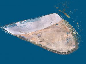
An empty Gold Camp reservoir scanned with a Trimble GX.
Refined field-to-finish scanning workflows are now a familiar tool for routine in-house surveying support. The projects are many and varied, and the following are a few examples, from quick-turnaround emergency response to longer-term program-level initiatives.
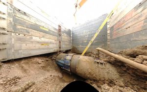
Emergency fabrication: A joint in a significant water main connecting a cast-iron pipe and a high-density polyethylene pipe of differing diameters was leaking and exposed for repair. The water main shut-off would negatively impact many customers. The manufacturer of the coupler to fit over the existing assembly required accurate dimensions fast.
As field crews experienced difficulties with manual measurements, LBS quickly deployed a scanner to collect data in the open pit, and solid models were created in the office. Extracted dimensions aided the fabricators, and a suitable part was made and installed.
Wastewater lift station as-builts: Springs Utilities operates 19 significant wastewater lift stations in which continuous operation is critical. As part of a system-wide condition assessment, LBS scanned all the lift stations, above and below grade. The wastewater engineering and maintenance staff uses the point cloud models for reference.
Springs Utilities produced this point cloud model for the Las Vegas Wastewater Treatment Plant pipe cross-connect using a Trimble GX.
Phase one of the project provided engineering design with models compatible with AutoCAD. Also, a hybrid of the point clouds and images are accessible via web browser for measurable photographs. From the CAD models, 3D PDFs are available for quick viewing and measurement within portable PDF viewing platforms.
Phase two will attribute the models with maintenance records, specs for pumps, etc. in a to-be-determined facilities management platform.
A Faro Focus scanner was used to scan the Edward Bailey Treatment Plant in Colorado.
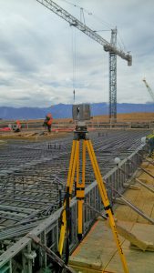
Water main replacement project roadway surveys: Springs Utilities’ program for aging infrastructure often requires a surveyor to physically collect positions of underground locates, topography, and above-ground equipment for design engineers. A single surveyor typically uses a robotic total station or survey-grade GPS to collect field data. In the interest of safety and the advantages of gaining more data, the LBS team considered using the scanners for this work.
As a proof of concept, a busy intersection was scanned from multiple positions. In RealWorks, features were extracted and accurately mapped in a desktop environment.
Scanning from static setups has limitations in a roadway survey setting. Moving along a lengthy alignment with individual setups is too time-consuming. Static scanning of intersections is plausible; however, moving obstacles like pedestrians and cars can obscure ground features.
Clever software routines isolate the ground and different vantage points, increasing the odds the ground is scanned from one of the setups between moving objects. Despite this, a colorized point cloud via associate imagery is important to differentiate the painted locates and other features. In a congested intersection, capturing lidar and imagery between moving obstacles is difficult. In this instance, capturing lidar and imagery while moving with the obstacles is the solution, which requires a mobile mapping system.
Going Mobile
The next logical step was to go mobile. Scanning from a static position is great, but if you need a large area or a long stretch of road, it is not feasible. Mobile mapping systems with lidar are not new; however, what is new is the ever-changing landscape. Lidar has combined with inertial navigations systems (IMU/GPS) components for commercial mapping for more than 20 years. Until recently, mobile mapping systems required manned aircraft or a dedicated vehicle, and they were very expensive. Neither of these scenarios suited Springs Utilities’ needs or budgets.
The autonomous car is driving the development of lidar sensors as never before. The promise to sell tens of thousands of lidar sensors is pushing manufacturers to make systems lighter, smaller, and affordable. The development of MEMS (micro electrical-mechanical systems) IMUs also reduces the weight and cost for mobile lidar systems.
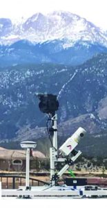
A LiDAR USA Snoopy in the shadow of Pike’s Peak.
In 2018, LBS acquired LiDAR USA’s HiWay Mapper HD, featuring the Velodyne HDL-32E lidar and the Ladybug 5+ 360o camera. In addition to meeting accuracy and budget needs, the HiWay Mapper HD’s versatility was a key factor in the decision process.
LBS needed a mobile lidar system that could go from one platform to another. Currently, LBS uses the system mounted to the rear of a pickup truck but has plans to capture data from a backpack, an ATV, and a small boat. The HiWay Mapper easily moves between platforms.
Its lightweight nature also allows deployment on UAV. The ability to collect data on the ground as well as from the air with the same system is like getting two systems in one.
Mobile mapping requires the calculation of the sensor’s trajectory. Trajectories are calculated using a PPK (post processed kinematic) solution, and the geo-referenced point cloud is generated with LiDAR USA’s ScanLook software. The resulting geo-referenced point cloud is imported directly into RealWorks, which allows Springs Utilities to continue to use existing design and engineering processes.
The HiWay Mapper HD showed its efficiency upon arrival. Construction of a new bridge over a creek bed required LBS to locate and map the utility structures. Surveying by hand would have taken about two days. Terrestrial scanning captured all the structures in 20 individual set-ups, about a half-day of scanning. The same area was captured with the HiWay Mapper in less than 15 minutes!
Springs Utilities has many projects planned for the HiWay Mapper HD, including the water main replacement program. Deploying the system on a UAV will allow for rapid mapping of reservoirs when they are low or empty and the mapping of the rugged mountain terrain around the reservoirs. In ten years, Springs Utilities has come a long way from single shots on a total station.