November 2016 Archives
UAS: Measuring for Solar
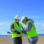
Above: The Mortenson team prepares their senseFly drone for flight. With a UAS, a construction firm finds value—in addition to what can be measured—in real-time assessment and data availability. Surveying plays a crucial role in construction, from initial planning to final as-built verification, often in multiple phases. However, terrestrial survey methods come with challenges for […]
November Editorial: Cue Team Building

For five days last week, I was dreading coming to work on Friday. It was the day most of my staff was excited about, but definitely not me. Let me backtrack. We at xyHt provide you, our readers, with lots of solid information about new technologies, skills, and ideas on operating your geospatial businesses. What […]
The Scanning Stalker: Who’s That In My Point Clouds?
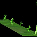
There he is again. This is the third time today. I keep finding him in my scans–hiding behind some tree or peeking around a corner. I keep an eye out while I’m in the field, but I’ve never caught him in the act. I’ve gotten used to it over the years, but it still gives […]
The Essential Carlson

A new pair of reference and self-study books gives the self-starter everything you need to know to get up to speed in Carlson software. Even if you’re not a current Carlson user, you’re probably familiar with the name and company. Founded by Bruce Carlson, a civil engineer, his namesake company has produced civil engineering and […]
Cross-Pacific Ties and A Disturbed Monument
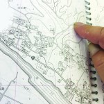
Above: The surveyor who set the original stake in Hyu-ga, Japan shows the spot in the Zenrin map book of the Miyazaki Prefecture. Located 28,280,841 feet +/- from original location. Editorуs note: A chance discovery by an Oregon beachcomber has forged cross-Pacific ties between two coastal cities–and their respective surveying communities. A few months ago, […]
3D Software, Not Really Like CAD at All
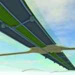
Above: InfraWorks 360 uses engineering rules to ensure that vertical and horizontal curves in infrastructure elements have the proper radii. Take a close look at Autodesk’s InfraWork’s 360, an unusual 3D modeling software. Editor’s note: For many firms and practitioners of surveying, photogrammetry, mapping, and remote sensing, traditional deliverables to AEC clients have focused on […]