xyHt in print, July 2015 Archives
Stockpile Reports
How to do enterprise inventory management from image-based 3D reconstruction, in the cloud and in your pocket. “No one wakes up in the morning thinking that they need to buy a point cloud,” says URC Ventures CEO David Boardman. “Most people would be thinking that they need to solve some business problem.” What URC Ventures […]
Mapping the Appalachian Trail, Part 2

How the AT was brought into GIS via a collaboration among ATC staff, NSP professionals, and dedicated volunteers. Part 1 of this article (May 2015) reveals the history of the trail, particularly how the land that comprises it was surveyed. Read here about how the trail was brought into GIS. In 1998, the Appalachian Trail […]
A Mapping App for Utility Assets

How a service provider for utilities implemented a mobile app to clock up efficiencies in advanced meter systems. Editor’s note: Mobile apps for asset mapping and mobile data management went from “new-cool” to essential in just a few years. In our April issue (see Mapping Peripheral) we tested a peripheral device that can add precision […]
Robots

Above: GPS-controlled robots can measure a site fully automatically and precisely anchor screws for the foundation of a solar plant. Measuring and Anchoring As a child I used to watch a program on BBC television called Tomorrow’s World. Once in 1981, I sat in awe as it showed a snooker-playing robot. My dreams were filled with […]
Signs of Change

Above: This image, created with Woolpert’s online QC tool eQAS, illustrates the ability to review sign data from multiple perspectives and provides lidar and image data at the location of each sign. One collect, multiple uses. A mobile mapping system (MMS) is a versatile tool capable of creating both GIS asset inventories and design-level mapping […]
Survey Law
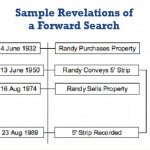
Seniority of Title and Forward Search I am often a part of litigation involving surveying services and research mistakes. (I must admit that, in excess of forty years of practice, I have made my share of mistakes performing record research.) I’ve observed five common research mistakes often made by surveyors. This article explains the common […]