Tag Archives: data collection
Staying Fluid: The Ocean Decade
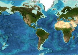
More than 23 percent of the ocean seabed is now mapped Seabed 2030 is a partnership between the Nippon Foundation and the General Bathymetric Chart of the Oceans (GEBCO) and aims to map the entire planet’s seabed by 2030. To date, the project has mapped around 23.4 percent of the seabed. The latest data was...

Ocean Observation
Monitoring and comprehensive data collection is now a national security imperative For most of the second half of the last century there was general agreement that the primary existential threat to humanity was the purposeful or accidental exchange of nuclear weapons. While that threat has not been completely eliminated, in the 21st century there is...
Geospatial Excellence
MAPPS recognizes the best geospatial projects of the year At its winter conference in Denver, MAPPS presented the annual Geospatial Excellence Awards to member firms whose entries exemplify the professionalism, value, integrity, and achievement of the firm’s staff as demonstrated over the previous year. The awards spotlight and honor the MAPPS members’ important and impactful...

Walden Environmental Engineering Captures New Insights and Revenue
Emesent Hovermap was used by Harkin Aerial to conduct internal and external scans of assets for Walden Environmental Engineering. This resulted in simplified and streamlined projects with improved efficiency.

The Center for the Arts in Nevada County, California Optimizes Operations
Mobile LiDAR scanner Hovermap was used to conduct an internal and external scan of the facility in just over an hour to capture accurate as-builts and CAD drawings.
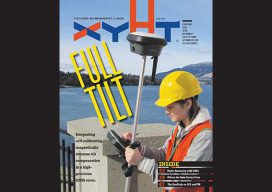
xyHt Magazine June 2018 Issue
Click on the cover below to view the June 2018 issue of xyHt magazine. Articles in the issue include (links will turn live throughout June): Full Tilt – Beyond the electronic bubble: Integrating self-calibrating, magnetically immune tilt compensation in a high-precision GNSS rover. Surveying Beyond the Water’s Edge – A remotely controlled unmanned survey vessel gives a land survey...