
Drones are taking on an increased role in the world of mapping and surveying, with some companies specifically tailoring their products to appeal to this market.
For instance, the companies UAVOS and Polynesian Navigation Inc. have collaborated to develop a long-distance autonomous UAS for 3-D mapping.
Powered by UAVOS’s autopilot, the UVH -25EL unmanned helicopter takes off and lands and conducts its missions autonomously.
Polynesian Navigation developed the system’s integrated PolyScanner Aerial 3-D Mapping and Surveying system. Featuring a choice of lidars, a global shutter camera and dual frequency RTK GNSS/INS with centimeter-level accuracy, the system can create accurate colorized 3-D models in a point cloud format.
The companies Silent Falcon UAS Technologies recently partnered with Silvus Technologies to equip the Silent Falcon UAS with Silvus’ advanced technology MIMO MANET Streamcaster communications systems, as part of a push into the mapping and surveying market.
The system includes Silvus’ new SF ATAK Field Observer Kit, which provides streaming videos with map overlays. The companies say the communications technology has been proven in a wide range of industries, including mapping and surveying, oil and gas and pipeline and tower inspection.
Delair, based in Toulouse, France, but with a strong U.S. presence, has developed a drone, the UX11, aimed specifically at mapping. A fixed-wing design, it includes am embedded global shutter camera, centimeter-level GNSS sensor and post-processed kinematic capabilities for survey-grade results.
CEMEX, a construction company, recently announced it will use the company’s delair.ai platform at its 60 sites in France under a three-year agreement. The cloud platform will incorporate data collected by drones, satellites and other methods to provide CEMEX with highly accurate, 3-D topographic surveys. The system can also provide orthophotography, slope maps, digital surface models and 3D models.
Indshine, a mapping company based in New Delhi, India, started up in 2016 but reported last year it had already picked up over 1,000 customers from 126 countries. The company said its user base includes drone mapping companies, GIS experts and enterprises from mining, construction, and agriculture.
According to Indshine, its platform “simplifies the consumption of drone and satellite maps,” which helps customers analyze maps in real-time collaboration.
“With Indshine we are able to provide our clients with easy access and analysis of the up-to-date state of the construction sites,” says Marko Culic, head at AGS Geosystems, which provides UAS-based technologies in Serbia for mining, civil and land surveying corporations.
The company reported being able to shave six months off the construction of an oil and gas facility in Mexico, where the owner of the company was from Spain, the consultant was from Mexico and the architects were in Montana and Louisiana in the U.S.
Using DJI drones carrying Agisoft Photoscan software generated high-resolution drone maps every three months during construction, keeping the shareholders in the loop and ultimately shaving time off the construction timeline.
Drone training
Woolpert, an international architecture, engineering and geospatial mapping company, last year became the first drone services provider to get approval from the Pennsylvania Department of Transportation (PennDOT) to use drones for state projects.
Woolpert’s surveying, mapping and geospatial professionals completed PennDOT’s UAS training, part of the agency’s certification process. UAS operators are also required to obtain a Part 107 Remote Pilot Certificate through the FAA.
“The commercial use of drones is moving in the right direction, as evidenced by the many required UAS qualifications,” says Woolpert UAS Technology Manager Aaron Lawrence, one of the Woolpert employees who took the training.
The company currently employs 18 FAA Part 107 certified pilots.
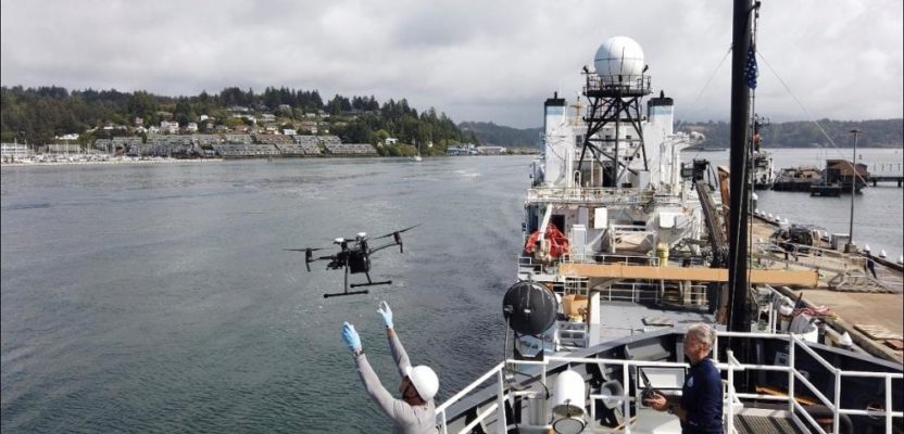
Mapping drones are also useful in maritime situations. Late last year, seven National Oceanic and Atmospheric Administration ship officers and Navigation Response Team members were trained on UAS operations by the companies DARTDrones and Oceans Unmanned.
Training included classroom instruction and hands-on flights that focused on research and mapping missions conducted from vessels. Students also practiced launch and recovery procedures, and programmed mapping missions from the deck of the NOAA Ship Hi‘ialakai while alongside the marine facility at the NOAA Marine Operations Center in Newport, Oregon.
“We have multiple years of experience in vessel-based drone operations supporting missions including wildlife surveys, habitat mapping, shallow water shipwreck surveys, and more, and are excited to assist NOAA in utilizing these systems safely and efficiently,” said Brian Taggart, chief pilot of Oceans Unmanned.
“These relatively inexpensive, off-the-shelf drones have the capability to support a wide variety of ocean and coastal environmental research projects,” he says.
NOAA is integrating small UAS aboard their survey ships for near-shore and shoreline feature charting, Taggart says,“by supporting or augmenting traditional shoreline verification and mapping techniques used by hydrographic survey field units.”
The NOAA National Geodetic Survey (NGS) Remote Sensing Division supported and funded the training.
XPONENTIAL 2020
Use cases such as these, and many others, will be featured at XPONENTIAL 2020, May 4-7 at the Boston Convention and Exhibition Center. Attendees can learn about the latest sensor and payload technology, use cases from across a wide range of industry, with several sessions focusing specifically on geospatial technology and best practices.