Sponsored by Xponential
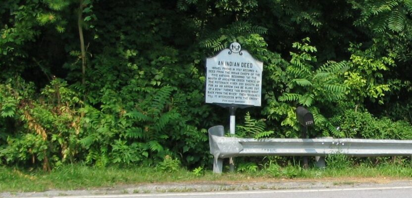
 With apologies to both the residents of southern Washington County, Maryland, and to the Native Americans; this title reflects an old, somewhat derogatory term for an area, and the title of a sign placed by the Maryland State Roads Commission in that same area. As I was driving along Harper’s Ferry Road recently, I crossed Antietam Creek on an ancient stone arch bridge and rediscovered the sign pictured here. Of course, I had to stop and get another picture of this historic sign.
I had taken a picture of this sign many years before when I happened upon it on a sight-seeing drive with my wife. At that time, I reflected on my former mentor and survey party chief, Bob Banzhoff, who had shown it to me on one of our forays into the area to perform a boundary survey. When we went to that area along the Potomac River, south of the confluence of the Antietam Creek, we always joked about going to Dangerous Dargan. That name came from the village there and the fact that several surveyors had been threatened with guns back in the old days.
As I continued my drive, I went past several landmarks, crossroads, and buildings that reminded me of the difficult surveys that we had done many years ago. I realized that what made this area so problematic for surveyors was the topography, combined with the practice of clearing land and placing fences wherever it seemed practical, without regard for property boundaries. As the land got transferred through the generations by the probation of wills, those fences and woods lines were often honored as the boundaries, and they didn’t want to hear what any surveyors had to say about where the deed placed the corner.

This reminiscing while driving down memory lane, caused me to think about what the possible correlation might be between the old “Indian Deed” and these conflicts that arose among the property owners in that area so many years later. I began to muse about what other odd measurements may have been used in land transfers in the late 18th century and early 19th century that may have led to similar poor deed descriptions. Maybe they threw big rocks a certain number of tosses, and where it landed on the final toss, it was monumented with other stones piled on top of it – there are many corners in that part of the country that are marked by stone piles.
In fact, it was just north of this area where I was on the crew that did a survey on a piece of land owned by a man named Nick Salamone. I wrote about this particular survey in my book. Nick wanted us to set iron pins at each of his property corners. We told him that it would not be possible because some of his corners called for a fence post, and we had found what seemed to be the original fence post corner. He asked for a pin to be driven in next to the base of the post, which we refused to do since it would be wrong and cause confusion. We also pointed out that we had found one of his corners that was referenced in the deed as a “Large Rock.” He complained that just because someone threw a rock at a rabbit and it landed near the location of his corner, he didn’t want that marked for his boundary. We had a good laugh about that since the rock that we found was larger than a VW Beetle.
On this recent excursion, when I stopped to get a picture, it was with my cell phone (something that didn’t exist on the previous stops there), so I thought it would be good to post it on social media. This brought some comments from friends, co-workers, and other surveyors. Of course, my old friend and mentor, Bob Banzhoff commented:“…you caused me to look it up. I can email you a PDF of the actual recorded deed if you like.” Of course, I said, “Yes, please.”
Well, Bob, being the consummate surveyor that he is, researched this deed online, on the Maryland Land Records page, and after finding it, sent it to me with a full historical background on the formation of the various counties in Maryland. This deed was actually recorded in Prince Georges County, of which Frederick County and Washington County were a part. As I looked upon this carefully transcribed and hand-written deed from the year 1727, I was amazed that the wording was just as the sign had proclaimed. After all of these years of wonderment and cause for much discussion, amusement, and glee, I found the deed to be real and actual. What a great time to be a surveyor, when ancient history can come alive in digital format through the Internet.