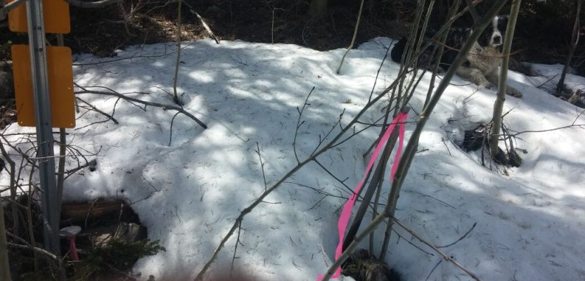
The sunlight had magically poked through the winter aspen forest in such a way as to warm through two areas in the snow, both of them survey monuments lying about four feet apart.
One was a 3 and 1/4-inch aluminum cap, stamped with the surveyor’s state license number, posted with a government-issued, yellow “Forest Service Boundary” sign. The other was a smaller aluminum cap, with gray-aged wood laths leaning over it.
A hairy woodpecker’s pecking, sounding like a log bongo player, was the only thing to be heard until Igor Kidinsky (field-named Eager, The Kid) chortled, “Looks like we have another pin garden!”
He was talking to his boss, Glenny Dale (aka Glutton, The Old Man).
The Old Man unshouldered his knapsack, which held coffee, a Swiss Army knife, and a pile of paperwork prepared for the project. He rummaged through it several times before he surrendered, anguishing for the subdivision plat he had printed for this very purpose, which was in his office.
Meanwhile, Eager had brought up both the old subdivision plat attached to the little monument and the Forest Service plat attached to the big monument from the online county records, displaying them side by side on his phone. He positioned them underneath The Old Man’s moose-like nose.
“Obviously, the local surveyor did a poor job of retracing this Forest Service line when he set this little aluminum cap in 1983 for a subdivision corner recorded in 1979,” The Kid concluded.
“Look at how complex and curvy this particular line is! In 1979, they had to use HP 25s. In 1983, they used Kern DKM instruments to thread their way through this thick forest and probably recorded a bad vertical angle. But here, in 2010, it says right on this plat that our modern surveyor used GPS and is complying with the BLM Manual and state board that requires him to set this pin garden.
“So, we are done researching this complicated mess because we have the U.S. Forest Service on our side,” proclaimed The Kid, quite proud of his knowledge of historical surveying instruments.
Glutton was also proud of his prodigy’s understanding of historical survey instruments and nodded in agreement at the same moment that a series of loud pecks from the woodpecker rang out. The nodding of his head indicated a forthcoming story of the history of this very area, much of which he lived through as a citizen.
“There is no free or orderly country without surveyors,” The Old Man stated as a preamble. “We are standing in an area that is the headwaters of the Colorado River. Grand Lake is named Spirit Lake by the Ute, Arapaho, and Cheyenne, who fought so much over this territory that legend says their dead filled the lake with spirits.
“In this very vicinity, three county commissioners and a sheriff were killed in a shootout over the disputed location of the county seat in 1883. Miners had ballooned the population of Grand Lake to over 300, and town leaders with financial interests began talking about how much more sense it would make to move the county seat.
“One of the rumored suspects—never found—was William Redman, a Grand Lake deputy who claimed to have ‘laid out the town’ and who apparently bribed a deputy surveyor, whose testimony in the murder trial was deemed ‘suspect.’”
Pointing to an imaginary line about 200 feet north, The Old Man lectured on. “The location of that section line was settled in the Colorado court of appeals. There have been three government lake meander surveys because the first meander of Grand Lake was erroneous, and the G.L.O. even recorded a “Grand Lake Townsite” survey, which affects the ground we walk to this day.
“The ‘first’ white settler, Judge Wescott, is rumored to be surveyor, judge, sheriff, and developer of this very ground, all in one! We are left with an irregular-shaped tract of land bounded on one side by our 1979 subdivision and the other by Forest Service land.
“It is our job to retrace the work of Wescott, who recorded the plat in 1887 that I left in the office.”
The Kid listened carefully while pulling up the BLM Manual on his phone, where he cited Chapter IX: “A survey of public lands does not ascertain boundaries, it creates them!” he shouted.
“True,” interrupted The Old Man. “But this irregular tract was not established by the federal government when they did their surveys; thus it is left to local, state-licensed surveyors.
“We enjoy peaceful law and order, requiring the faithful execution of boundary surveys and the recognition and abiding by the public of all their little monuments, like this fellow’s.” He pointed at the smaller aluminum cap.
“And, what that surveyor’s big cap means is that he is bound by state law, which he discarded under the mistaken belief that the Forest Service goes around planting pin gardens.
“That big cap means only that one surveyor did a very good job of calculating on a computer and marking a coordinate on the ground, using tools that did not exist in 1979. There were local people scalping each other, shooting each other, and suing each other over this territory, long, long before there was ever such a thing as a ‘national forest,’” concluded The Old Man fondly.
The sound of the crunching snow and ruffling of papers made by two surveyors packing their gear was drowned out by the sound of the woodpecker solo, made by a large bird with a large beak, demanding the two intruders leave his space in the woods.