Tag Archives: close-range photogrammetry
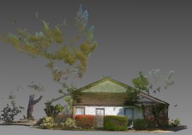
Accuracy with a Phone?
Photogrammetry is now possible using consumer devices, and the applications are vast. Continuing improvement in digital cameras—including those in cell phones—and in photogrammetry algorithms have enabled dozens of consumer and professional photogrammetric applications. Among the professional ones is PhotoModeler, which produces accurate maps, drawings, CAD data, 3D models, and photos draped on 3D models. Its...
Pix4D Mapper
Imagine walking up to an object with practically any camera and taking photos of it at different angles. Now imagine uploading those images onto a computer and being able to create a survey-accurate point cloud. Sounds impossible, huh? Too good to be true? That’s what I thought when I first heard of Pix4D. When I...
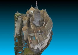
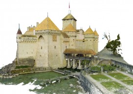
Chillon Castle: A Pix4D Sample Project
Above picture: Point cloud of full model of castle, shown from the top I wrote a review of Pix4D’s Mapper software in the November print issue of xyHt; check it out. Here’s Pix4D’s sample project to showcase the power of their software. They chose to create a model of Switzerland’s most visited site: the Chillon...

Imaging Rover on the Canal
A Florida surveying company puts a new technology to the test on an historic canal fronted by 21 subdivisions. Editor’s note: The announcement of the Trimble V10 imaging rover in late 2013 was greeted with a mix of excitement and questions (“what is it?”). With close-range photogrammetry just beginning to reach the toolboxes of surveyors...