Tag Archives: drones

New Products, Training Highlight Drones’ Increased Role in Mapping and Surveying
Drones are taking on an increased role in the world of mapping and surveying, with some companies specifically tailoring their products to appeal to this market. For instance, the companies UAVOS and Polynesian Navigation Inc. have collaborated to develop a long-distance autonomous UAS for 3-D mapping. Powered by UAVOS’s autopilot, the UVH -25EL unmanned helicopter...

How to Get a Drone License
Here is a step-by-step guide to the basics of obtaining an FAA 107 commercial drone license. So—you’re stepping into the aerial arena, taking command of your first unmanned aerial vehicle (drone). Given their usefulness in a wide range of geospatial work, that’s absolutely a smart decision. But you know it’s not as easy as grabbing...

UAVs Enter the Sharing Economy
Above: A hypothetical Hangar mission plan for a city. A new platform connects UAV owners and UAV users while providing flight plans and image processing. As the UAV industry continues to grow rapidly, many companies are wondering whether they should own and operate their own UAV and, if they decide to purchase one, how they...

Build, Buy, Rent, or Hire?
Seven years ago I was invited to attend a UAS flight course; this was an exciting proposition as the drone craze was not yet under way. In fact, the rules for operating drones in the U.S. were so in flux (as far as commercial and private drone use) that the course had to be held...

In The News: A Geospatial Year at Woolpert 2017-2018
Woolpert has been in business for 107 years, building a strong, broad-based foundation through engineering, surveying, mapping, photogrammetry, lidar collection, GIS, etc., to provide the most comprehensive geospatial support in the industry. In the past year alone our work in each of these sites, represented by these red dots, were spotlighted in the press. They...
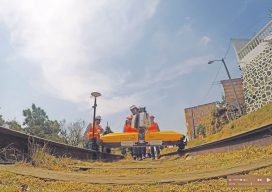
Mexico City’s Transportation Revolution
Using drones, lidar, and BIM, enterprising surveyors and geospatial engineers designed and constructed the city’s first high-speed train system. Editor’s Note: Lessons learned from a problematic rail project in Mexico City prompted an initiative to pull out all technological stops for a subsequent new rail line. An innovative, tech-savvy firm that had demonstrated its capabilities...