Tag Archives: GIS
QGIS v ArcGIS
Okay, so I’m likely to get lynched, but before all the lovers/haters come out of the woodwork I’d like to remind everyone that these two systems are both great achievements. We are looking at two software systems that have changed the way we look at the world and the way we think about the world...
Call for Abstracts for 2015 GIS in Action!
Mark your calendars for May 4-6, 2015 and join us in Vancouver, WA at the Hilton Vancouver Hotel and Conference Center for the 2015 GIS in Action conference. This year’s conference is jointly sponsored by the Oregon-Southwest Washington Chapter of URISA (ORURISA), Washington State Chapter of URISA (WAURISA), and the Columbia River chapter of ASPRS...
Open Source in the UK
Contrary to popular belief, it was neither the UK government nor Britain’s national mapping agency, Ordnance Survey, who started the UK open-source movement. Although open source was present and used in the UK before 2006, it was The Guardian newspaper that started a campaign called “Free Our Data,” which called for the raw data collected...

Morphing Landscapes
Normally we create digital surface models (DSM) and elevation models (DEM) to analyze the topography and visual issues related to a project or issue. The requirement for accuracy and precision is paramount, ensuring that the correct method(s) of converting the data from raw source to an accurate model is more a work of art than...
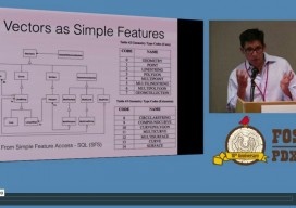
FOSS4G 2014
If you’re seriously into open source GIS, you were (or should have been) at the FOSS4G (Free and Open Source Software for Geoinformatics) international conference held September 8-13 in Portland, OR. An annual event since 2006, FOSS4G is large enough to attract the heavy-hitter vendors (e.g., Google, Amazon and Boundless), yet small enough to enable...
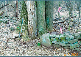
Critical Issues for GIS/Survey Cooperation
State Plane Coordinates in Legal Descriptions The time is now to have State Plane Coordinates (SPC) attached to key monuments that should be part of just about any legal description, in the proper context.* This has been discussed since the early 1980s and has been accomplished only on a piecemeal basis. With coordinate inclusion, a...