Tag Archives: GIS
Comparing Maps a New Way
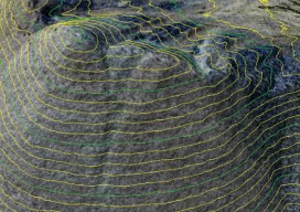
Above: The new standards are independent of map scale or contour interval and provide a way to deal with lidar data. ASPRS releases new positional accuracy standards. The positional accuracy of geospatial technologies has improved dramatically in the past few decades, and digital maps have replaced paper maps, making old ways of comparing maps obsolete. Satellite...
Should We Be Reading Maps or Moving Forward?
There has been a lot of press recently about an announcement from the Royal Institute of Navigation (RIN) declaring that “Society is being sedated by software,” and it would appear that most of the media have jumped on board, like the BBC, The Guardian, even the Western Morning News. I have to agree with them...
How to Add Transparent Text to ArcGIS in 4 Easy Steps
ArcGIS is a great piece of software but has some small functionality missing which, to a cartographer or perfectionist (like myself), can be a little frustrating. So I was really pleased when I discovered a way to create transparent text, something which has eluded me for a long time in ArcGIS. Lets consider this map:...
Esri Developer Summit 2015 Highlights
The 2015 Esri Developer Summit (colloquially referred to as the “DevSummit”) was held in Palm Springs, CA, March 10-13. Two thousand+ programmers and technologists participated, seeing the latest developments for building applications in ArcGIS web, desktop and native coding environments. I particularly enjoy the DevSummit events, since they are entirely geekfest in nature, as opposed...

Maptime – A [UK] user experience
A year ago if you had said “Maptime” to me, I would have thought you were mad. I have now been to three “Maptime” events, and I want to share my experience, as you may be sitting there perplexed as to what you would gain from it. Maptime is increasing in popularity. Before Christmas [2014]...
Feature: Discovering Lee’s View
A geography professor uses GIS to recreate the Battle of Gettysburg, discovering what General Lee could and could not have seen to guide his fateful decisions. Advances in tech-nology in the last 150 years have been remarkable. In our industry we have seen many changes in our surveying methods and in mapping practices in general....