Tag Archives: hydrography
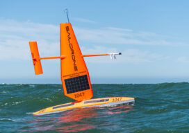
Ocean Mapping Effort Makes Progress
Two new partnerships will advance Seabed 2030’s mission to map the entire ocean floor this decade Since ancient Egyptians began studying the Nile River, bathymetry has been the crucial component in hydrography. The great river gave rise to their great civilization, providing fertile soil for farming, water for irrigation, and a means of transportation...

xyHt Weekly News Recap: 6/23/23
New Seafloor Mapping Program Supports Marine Safety and Planning in Two Indigenous Communities Alameh Selected as Inaugural Executive Director of Taylor Geospatial Institute LexisNexis Improves Insurer Risk Assessment Portfolio with National Tree Map SAM Companies Acquires AXIS GeoSpatial Leica Geosystems Introduces Hybrid Imaging and Lidar Sensor for Airborne Mapping GEO Business 2023 Receives Glowing Reviews ...
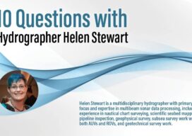
Q&A: 10 Questions with Hydrographer Helen Stewart
Helen Stewart is a multidisciplinary hydrographer with primary focus and expertise in multibeam sonar data processing, including experience in nautical chart surveying, scientific seabed mapping, pipeline inspection, geophysical survey, subsea survey work with both AUVs and ROVs, and geotechnical survey work. How did you get interested in hydrography. Did a specific event trigger your...
The Responsibility to Map the U.S. Coastline
(And the Inevitability of New Geodetic and Tidal Datums) Since the arrival of the first pilgrims to the North American continent, there has been a need for precise knowledge of the coastline of the new country, and the reasons are obvious. Arrival by boat was the only alternative when crossing the Atlantic and escaping religious...

THSOA: New Website and US Hydro 2023
Staying Fluid The Hydrographic Society of America (THSOA) is a 501(c)3 non-profit organization committed to promoting education in hydrography, inshore surveying, inland waters surveying, offshore surveying, positioning and mapping/charting, including related earth sciences. We have organized in a National Board, including the president, secretary, treasurer, and four trustees, and our members by geographical regions, in...
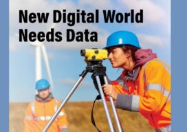
New Digital World Needs Data
Next-generation surveyors require specialized education and training to fill the role of geospatial data specialists. Many emerging geospatial applications, such as digital twins, 3D modeling, monitoring, virtual reality, and autonomous vehicles, are based on big digital datasets. Building a 3D digital world starts with accurate data that ties to a point on the ground, so...