Tag Archives: hydrography

xyHt Weekly News Recap: 10/14/2022
New NSRS Modernization Release Timeline: Mid-2025 Geo Week Calls for Nominations for Excellence in the Geospatial Industry Trimble Changes Headquarters to Westminster, Colorado Mapping Site ShowMyMap.com Rebrands to Mapize.com DOE Announces First Cohort of Post-Secondary Programs to Receive New Zero Energy Design Designation Ashley Hitt to Serve as President of URISA SmartGeo Expo 2022 to...
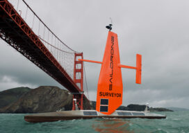
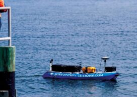
The Ocean Mapping Imperative
Wind and solar-powered uncrewed surface vehicles offer a boost to global surveying efforts. Since 2017, the Seabed 2030 initiative has raised awareness about the importance of mapping the entire seafloor to support a healthy and resilient ocean for the well-being of the entire planet. This partnership between the Nippon Foundation, the International Hydrographic Organization (IHO),...
xyHt Digital Magazine: October Issue
xyHt’s October issue focuses on data acquisition, whether from GNSS, your smartphone or the increasingly available satellite data that is being made on the Internet for free. As always, if you don’t have a subscription to our print edition, or if someone else in the office has snaffled your copy, don’t fret, here is the...
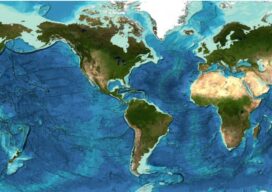
Staying Fluid: The Ocean Decade
More than 23 percent of the ocean seabed is now mapped Seabed 2030 is a partnership between the Nippon Foundation and the General Bathymetric Chart of the Oceans (GEBCO) and aims to map the entire planet’s seabed by 2030. To date, the project has mapped around 23.4 percent of the seabed. The latest data was...
xyHt Digital Magazine: July 2022
xyHt’s July issue focuses on Geographic Information systems, looking at how GIS helps surveyors improve accuracy and how GIS is the technology for the next era. As always, if you don’t have a subscription to our print edition, or if someone else in the office has snaffled your copy, don’t fret, here is the digital...
No Barrier Between Land and Water
Innovative tools and technology help hydrographic mapping deliver detailed data in previously inaccessible areas. Underwater mapping presents unique logistical challenges that are increasingly being met with technology used in creative ways, and by combining multiple types of data to develop a complete picture. From unmanned surface vessels (USV) to multi-beam sonar, advanced equipment yields accurate...