Tag Archives: lidar
Mapping the USS Arizona
A unique pro bono collaboration creates the first-ever integration of multiple technologies for mapping a historic monument. The battleship USS Arizona was bombed during the Japanese attack on Pearl Harbor on December 7, 1941. The ship exploded and sank, killing 1,177 officers and crew. It now lies at the bottom of the harbor. In 1961, Elvis Presley...
SGM
Obtaining economical and accurate point clouds from semi-global matching. In the old days, mappers were thrilled with 30 meter USGS digital elevation models (DEMs). These were available for almost everywhere in the United States. Years later they started producing 10m DEMs, and life was really good. We had one elevation point “on the ground” every...

3D GIS
Breaking the Wall between Consumer and Professional, the Appearance of Disappearance, Versioning An Interview with Lawrie Jordon Contrary to what the current buzz might indicate, GIS and CAD have been 3D-rich from their start (although sometimes with elevation as an attribute, not necessarily part of the core spatial definition). Even in the 1990s era of...
Arctic Quests
Multiple agencies and technologies merge to map a historic region of the Canadian Arctic. Adapted from the academic paper, “Arctic Charting and Mapping Pilot Project 2: Sharing Modern Technologies and Resources towards a Common Goal”, by Andrew Leyzack and summarized by Steven Keesee, with a history sidebar by Jeff Salmon.In April 2011, multiple organizations in...
Lincoln Memorial Project
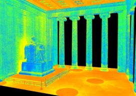
Above picture: A limited section of scan data, including the Lincoln statue. In December 2013, DJS Associates, Inc., a firm specializing in 3D scanning technologies,undertook a project of enormous magnitude on behalf of the National Park Service (NPS) and CyArk, a nonprofit organization dedicated to digitally preserving cultural heritage sites around the world. The goal: digitally...
Pix4D Mapper
Imagine walking up to an object with practically any camera and taking photos of it at different angles. Now imagine uploading those images onto a computer and being able to create a survey-accurate point cloud. Sounds impossible, huh? Too good to be true? That’s what I thought when I first heard of Pix4D. When I...