Tag Archives: Surdex
The 2017 Flooding of Missouri’s Meramec River
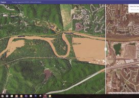
Missouri’s Meramec River is one of the largest free-flowing waterways in the state. With a source southwest of St. Louis, in Dent County, and the mouth at the Mississippi River in Arnold, some 20 miles south of St. Louis, its meandering 220 miles drain nearly 4,000 square miles in a watershed covering six Missouri counties....
Satellite Imagery’s Impact
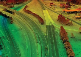
Above: The highest resolution of commercial satellite imagery is still more than an order of magnitude lower than the highest resolution attainable from aerial platforms. Keystone Aerial Surveys, Inc. developed this digital surface model from 1.75 cm digital imagery taken with a low-altitude flight. The resolution is sufficiently high to enable its use for mapping...