The regulations and uses of UAVs for mapping in Latin America are as diverse as those cultures, but their drivers are much the same as we see here in the United States.
Using manned airplanes for aerial photography and photogrammetry is an especially expensive proposition for countries south of the Rio Grande. The reasons are not simple, but suffice it to say that general aviation (GA) is not as common as it is north of the border, and manning and maintaining these aircraft is not as easy or affordable as in the U.S. where GA is an established and thriving industry. Owning and operating an aerial photography aircraft in Latin America is a costly and burdensome endeavor, a necessary evil for mapping companies based in those latitudes. This has opened the door for the unmanned aerial vehicle (UAV) revolution.
A saying goes that “technology moves faster than government regulations,” and in this case we could say, “some governments move faster than others when it comes to new technology.”
The Echar 20A is a UAV designed and built in Brazil by the company Xmobots. Courtesy of Painel de Fundo.
In the U.S., the government, through the Federal Aviation Administration (FAA), has established temporary guidelines that regulate and restrict the use of UAVs while Congress enacts more permanent legislation. Now imagine the task of defining the state of the mapping UAV industry in a sub-continent in which each country has a separate civil aviation administration and different regulations for the importation and use of any type of aerial vehicle.
Generally, most civil aviation authorities in the region have not been as quick to act as the FAA, and, given the fact that skies are not as busy or regulated as in the U.S., the urgent need for this legislation is seriously questioned. Given the diversity of legislations and applications in the major markets in the region, I address here those countries that are most active and those that are moving forward with regulations of their own.
Argentina
This South American country located at the bottom of the sub-continent was once the breadbasket of the world between the hard years of the Great Depression in the U.S. and the beginning of WWII. It is logical then that usage of mapping UAVs in Argentina focuses on applications related to agriculture, such as crop health and drainage. Other markets involve mining and rural cadaster.
Regarding the status of UAV legislation, Argentina has opted for a wait-and-see approach in which the civil aviation authorities are monitoring very closely the development of the market and the proliferation of the number of units actively flying.
The main issue in Argentina these days is not the fact that UAVs are allowed to fly or not but the importation restrictions that the left-leaning government has imposed on foreign manufacturers of equipment in general. Argentina does not have an indigenous aeronautical industry, and, therefore, all UAVs are imported. The federal government has imposed strict rules on local companies engaged in the business of importing and selling foreign goods. Furthermore, the process for the allocation of hard currency to cover these purchases is ever changing.
Colombia
The armed forces of Colombia have been developing and using UAVs for a long time to fight drug trafficking, and, therefore in the specific case
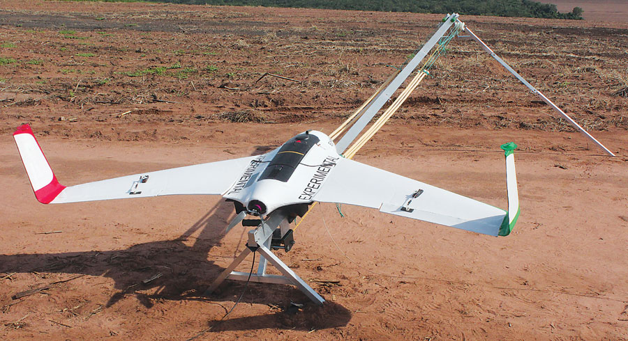
The Genesis, the UAS the Aeromao team used for most of the missions in Colombia from 2004 to 2007, features a 3.3 meter wingspan, weighs 20 kilograms, has a flight time of 2.5 hours, and incorporates STOL (short takeoff and landing) capabilities. Courtesy of Aeromao.
of this Latin American country, legislation is being seriously influenced by the need of the military to maintain a tight control of who’s flying and for what purposes.
The pressures of the market in terms of commercial UAVs entering Colombia for civilian uses have required the National Special Administrative Civil Aviation Authority to join efforts with the Colombian Air Force in order to pass legislation aimed at regulating an industry that would be difficult to stop altogether.
In Colombia various foreign manufacturers are currently selling their solutions to government agencies and private concerns that are using them for applications in mining, agriculture, oil and gas, and utilities.
Chile
Chile is the number one producer of copper in the world and has a thriving agriculture business, mainly for export of raw fruit and wine. Third on that list of large economic drivers is forestry, where Chile is one of the largest exporters of pulp and paper products in the world and has vast areas planted with Radiata Pine and Eucalyptus.
Chile is also the most stable country in the region, politically and economically, with a fully functional financial sector, open markets, and a robust legal system that offers foreign investors a secure framework to operate and grow.
These conditions have allowed the UAV industry to thrive in Chile from a very early stage, mainly in volumetric applications for open pit copper mining in the north of the country and vegetation health in the south.
The status of the UAV legislation is unclear at this time, but, in a country with very clear guidelines and legal framework for every other commercial activity, it won’t be long before regulations are enacted. In the meantime, flights of mapping UAVs are taking place daily, mostly in remote areas and over privately owned land.
Ecuador
This small South American country is one of the most progressive in terms of the involvement of their mapping agency, the Military Geographic Institute (IGM), in the use and regulation of UAVs for commercial purposes. Recently, the IGM, in partnership with a local UAV and survey-equipment distributor in Quito, successfully flew and mapped the scientific base of Ecuador in Antarctica. This flight took place under extreme conditions of temperature and winds and proved that mapping UAVs are here to stay. You can read about the project in the September issue of xyHt and on xyHt.com.
The Ecuadorian government is currently evaluating legislation to regulate the use of UAVs for civilian mapping and agricultural applications.
Brazil
Given the large geographical expanse of this South American country and the fact that Brazil has a thriving aerospace industry, you might expect it to be the most advanced in terms of UAV legislation. This is true to a certain extent. The National Association of Civil Aviation (ANAC) has recently announced that it will publish a first draft of the UAV law by the end of 2014, and the final version will be submitted to the Brazilian congress for analysis by mid-2015.
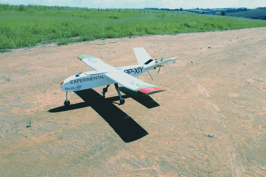
The Nauru 500 is a UAV designed and built in Brazil by the company Xmobots. Courtesy of Nauru.
A consultative process was implemented and launched by ANAC in 2013, and two meetings so far have taken place in which local and foreign manufacturers have joined other groups in discussing the pros and cons of the proposed legislation in an open forum. More than 25 local companies are investing heavily in the development of UAVs for all sorts of applications, from mapping and agriculture to real-time security of sport venues.
The case of Brazil is unique in Latin America due to the fact that it is home to one of the largest players in the aeronautical industry: Embraer. Embraer’s position is especially interesting in the case of UAV legislation. On one hand, they perceive this new technology as a threat to their existing customers in the sense that crowding the air with unmanned aircraft presents a potential hazard to existing aerial traffic. On the other hand, they are suspected of presently developing their own line of UAVs (very secretive so far) and therefore are interested in influencing the upcoming legislation to their advantage.
Keep in mind that Embraer is ANAC’s number one client when it comes to certification and airworthiness of new aircraft. ANAC and Embraer have a long history of working together, and this UAV legislation will not be an exception.
ANAC’s proposed legislation will classify UAVs into three categories:
- Class 3: from 0 to 25 kgs (>55 lbs)
- Class 2: from 26 kg to 150 kg (57 lbs – 330 lbs)
- Class 1: over 151 kg (<332 lbs)
It is clear that most mapping UAVs will fall under Class 3, and this specific group will have very little regulation as long as the flights are carried out at 400 ft. AGL (above ground level) or lower. ANAC will create a website for Class 3 UAVs, and operators will be required to register their aircraft.
In the meantime, the UAV industry in Brazil is thriving with many companies flying regularly, mostly under special NOTAMs (Notice to Airmen) and over scarcely populated areas for mining and agriculture applications.
Bolivia
This land-locked country is renowned for its mountains and harsh climatic conditions. The financial engine of the country is the city of Santa
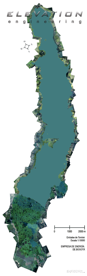
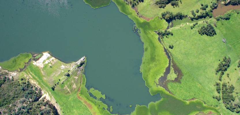
An orthomosaic image of the entire Tominé reservoir in Cundinamarca, Bogota, Colombia. Courtesy of Aeromao.
Cruz de La Sierra where the eastern slopes of the Andes join the steppes adjacent to the Amazon jungle, but most economic activity in the mining sector takes place in the high plains to the west.
Traditionally, the government of Bolivia has used UAVs to monitor and control the illegal plantations of cocaine in certain areas where it is not grown for consumption of the indigenous population and where it is considered a crime.
Bolivia and Chile share a border in the area where rich mineral deposits are found in the Andes, and therefore UAV applications on both sides of this man-made frontier confront a degree of difficulty when flying at altitudes of over 15,000 feet with prevailing winds of 40 knots or more.
Successful flights at these altitudes are common, and mining companies are now using mapping UAVs frequently to determine volume of mined ore and slope calculations. The use of these UAVs has allowed mines to keep surveyors out of the mine crater where traffic of haulers and equipment is most concentrated and where accidents are more prevalent.
Regarding legislation, there are no firm laws regulating the use of UAVs for civilian applications, but it is generally accepted that flights over scarcely populated areas for uses such as mining and agriculture are accepted as long as they remain below a certain flight level and fly over private lands.
Mexico
The situation in this North American country is favorable to the deployment of UAVs, and numerous have been already sold and are used regularly, especially in the northwest of the country where the mining industry concentrates and open pit mines abound.
Large photogrammetry companies are buying UAVs throughout the country and replacing some of their traditional aircraft with these small technological wonders, especially for missions that don’t require high-altitude flying or ultra-precision.
The government of Mexico has not officially regulated the use of UAVs over its territory and has been authorizing their use under certain conditions, such as defined altitudes, away from population centers, and over small areas.
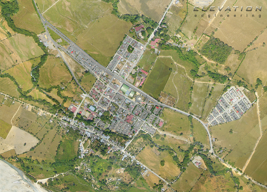
An orthomosaic of Castilla La Nueva in Meta, Colombia. This became the first UAS orthophoto officially inserted into Google Earth imagery by Google. Courtesy of Aeromao.
In terms of the UAV regulating agency, Mexico has a civilian aviation authority but also a mapping agency very much involved in the developing of the basic cartography of the country and with a deep interest in every new technology that could advance the cause of better maps at a faster pace and with better accuracy.
Applications in Mexico include mining, agriculture, and rural cadaster. Many open pit mines in the north and northwest of the country are flying regularly to control the volume of ore that is extracted over a period of time, and some are using this information to calculate financial viability of their mining concerns.
Regulators Under Pressure
Countries in Latin America have different approaches to the regulation and legislation of mapping unmanned aerial vehicles in their territories. For a chart of each country’s regulating agency and its website, legislation status, market segments, and applications, see this article on xyht.com. What all these countries have in common is the enormous pressure that both the private and public sectors are exerting on the regulators to come up with comprehensive legislation that would allow these entities to do their jobs at lower costs and more efficiently through the use of unmanned aerial platforms.
In that respect, these countries join the specific case of the U.S. where the FAA is working feverishly to come up with proposed regulations for an industry that has the potential to significantly impact the economy in a time when a tepid recovery is in dire need of new industries and new employment sources.