
Blog
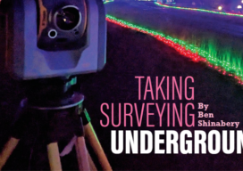
Taking Surveying Underground
By Ben Shinabery Louisville’s massive Mega Caverns presented challenges for a huge subterranean survey Every day more than 150,000 people drive past the interstate billboards advertising the Louisville Mega Caverns not realizing they just drove over what is classified as the largest commercial building in Kentucky, even though it is entirely underground. What once was...
Looking Forward: Underground Surveying
This month's issue features a story about underground surveying. Beneath parts of the Louisville, Kentucky is the Louisville Mega Cavern, an underground space of 100 acres created by years of mining rock.

xyHt Weekly News Recap: 03/29/2024
Global Surveyor’s Day is March 21 Public Comments Sought on Draft ASPRS Positional Accuracy Standard Version 2.0 Commercial UAV Announces 2024 Advisory Board Woolpert Acquires Ireland-Based Murphy Geospatial, a Leading European Geospatial Firm Chung Hsing Brings Geospatial Data Acquisition to the Next Level in Taiwan Topcon Announces MC-Max Asphalt Paving and Milling Solutions Bilanciai Group...
Introducing Exyn Nexys –
A modular mapping and surveying ecosystem that allows users to quickly capture highly accurate, colorized, real-time 3D point clouds in complex, dangerous, or inhospitable environments like those in the mining, AEC, and geospatial industries.
Let’s Get Real About Property
One of the more serious problems with the surveying profession is our schizophrenic relationship with property and the associated property rights. For my entire professional surveying career, too many surveyors seem to think we have nothing to do with property rights; that our job is to simply layout the math and measurements contained in the...
Questions & Answers: AI and AEC
Can artificial intelligence infuse more profit in the architecture, engineering, and construction process? And when will that happen?
Advertisement