The Art of Retracement
The Old Man–Glenny Dale–paced slow and steady, picking his way through the ankle-bending sagebrush while enjoying its sweet, springtime smell.
Eager (The Kid)–Igor Kidinsky–took a straight path along the old barb fence, crushing the twisted sage stems with solid stamps of his boots, lacking the patience of the old-timer.
Four white-tailed deer looked on, like a band of Ute scouts, curious about the seemingly harmless actions of this survey crew but wary of something dangerous sure to follow. The herd then bounced away from the crew in a straight line and stopped in unison a few seconds later and a thousand feet away, to observe from a safer distance.
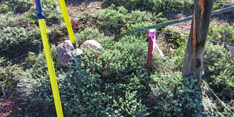
Both surveyors wished aloud that they could bounce through sagebrush and over fences so swiftly. At the end of their hike, the crew found their prize: a BLM brass cap in a mound of stone. They needed an existent corner for their old ranch boundary survey, but they saw a 1-inch iron pin standing up two feet away from the brass cap.
The notes said nothing about an iron guard stake or an existing monument being rejected. Or, especially, why the BLM would reject an iron pin to set a brass cap in 1974.
We are standing on the 6th Principal Meridian Baseline, and you will likely find some Ute arrowheads alongside the original stone placed in the 1870s, underneath this sage,
stated The Old Man, as if he had been there then, defending his survey crew against the valiant Ute arrows.
Follow this baseline west a few townships and you’ll arrive in the town of Meeker, named after the Indian agent who followed the call from Horace Greeley to “Go West” but managed to get himself and all his agents killed by the Ute whom he was trying to assimilate into our society.
Glenny Dale, walking historian, continued:
The Ute couldn’t be fenced in, even though Colorado, in the 1870s, was hardly a high society with its crude miners, cowboys, and loggers. The Buffalo Soldiers came to the rescue of the settlers in Meeker in the last of America’s Indian wars.
Eager (The Kid) listened while focusing on the ground, hoping to spot arrowheads. “Who set this iron pin, and why do we have a pincushion?” he reasoned. The Old Man knew the answer.
There are a lot of ranches and homesteads based on this baseline. The original stones were hard to find in this sagebrush. One guy came through and ran several miles of this line. He set axles and pins, like this, in 1971, and they can all still be found. He found most of the stones but missed a couple. A lot of property was laid out from this guy’s pins.
The BLM has corrected at least three of its own errors, which proves that they honor the original surveys.
Eager (The Kid) had switched his eyes from arrowheads to his phone, reading the 2009 BLM Manual: “A survey of public lands does not ascertain boundaries, it creates them.” “Hart v Cox!” blurted out The Old Man, recalling the 1947 Manual from memory. “Therefore,” concluded The Kid,
this iron pin created this property corner in the absence of the original stone. Surveyors set pincushions because they wish to display their more precise measurement skills, which is moot! The goal is to retrace the existing property line, which, according to this manual, was created by the original surveyor who set the stones in 1878, but since it was lost, was created again by this guy in 1971.
“Yes and, no,” said Glenny, dejectedly.
There are always exceptions. 1974 was a bad year for the BLM. This “dependent resurvey” was done just one year after the 1973 Manual came out. In all my work, I have found only two or three pincushions set by the BLM, and they were in this township, dated 1974.
I honestly think that survey crew stretched their authority and had misread the new Manual, and they had treated this iron pin guy as a “lesser” surveyor. In fact, you will find that most, if not all, BLM surveyors take great pride in retracing local surveyors’ work.
You will not find any BLM surveyor who openly admits setting multiple monuments over the matter of precision. They only reject local surveyors’ monuments based on whether or not they used correct existing government corners.
Two of those rejected monuments were mine. After about 1975, you will not find a government pincushion unless they had recovered an original stone that no other surveyor had found.
“”In fact,” said the senior surveyor,
the BLM has corrected at least three of its own errors that I can think of, which proves that they honor the original surveys. It’s all about finding existent corners, not about precision pincushions.
“So, we have a mess,” whined Igor. “Why isn’t two feet close enough?” “Oh, we have a big mess,” cried The Old Man.
The iron pin is used by surveyors and landowners since 1971. It is the true property corner. But, we are going to succumb to the pincushion and base our survey on the 1974 brass cap.
“But the brass cap is wrong! It’s a pin garden!” moaned Igor Kidinsky. “Yes, it is very wrong,” lectured Glenny Dale.
Let’s hope and pray that the lawyers aren’t called in. Because we can’t win against the BLM in court any more than we can defeat the Buffalo Soldiers with bows and arrows.
Eager (The Kid) kicked the dirt with frustration. His eye caught an object by his foot, an arrowhead, and he wondered if that arrow had been aimed at a survey crew or one of those white-tailed deer who, by now, had wandered off with great disinterest. “That’s the best stone you’ll find all day!” laughed the old surveyor, while he glanced around nervously at the sagebrush horizon, instinctively hoping that no Ute was watching.