Above: Hydromax USA data (sewer and gas) is combined with Nearmap imagery and Esri software, improving analysis and resource deployment.
A data-collection company transforms its services with clear, streaming imagery.
By Nicholas Duggan, FRGS, Cgeog (GIS)
When you get new aerial imagery, the first thing you do is look up your house. (It’s okay, we all do it.) How many of you are disappointed that the image doesn’t show much detail or shows the car you owned five years ago in the driveway?
How would you feel if you had just invested huge amounts of cash in a GIS with aerial imagery and found the imagery disappointing? What follows is how Hydromax USA changed its imagery supplier and found nirvana.

A comparison of Nearmap imagery (right) to older, lower-resolution satellite imagery (left).
Nearmap
Nearmap is an aerial imagery supplier and location content company that has gained popularity due to the high-resolution, clean, crisp, and current imagery it captures and provides via the cloud and web-mapping services.
To capture high-resolution imagery, Nearmap uses fixed-wing aircraft with the camera and positioning hardware built into the hull, ensuring minimum setup time prior to flight and accurate recording. A single flight allows capture of over 1300 sq km of multview stereo imagery. Yes, not just imagery, but stereo imagery, which means data can be ortho corrected (by using the DSM and subsequent DTM).
How are those images so clean and crisp? The imagery-processing pipeline includes automatic color balancing that produces the consistency, and the capture program is carefully managed to avoid cloud in the imagery.
Because Nearmap uses server-based photogrammetry software, processing all the data is faster and less demanding.
When you consider what makes Nearmap different, a continuous capture program that takes into account both leaf-on and leaf off collection surveys has to be top of the list. Nearmap has a repeatable, scalable process to capture, manage, and deliver location content for 70% of the U.S.
The Service
How do you manage and process imagery that covers 70% of the U.S. population? Because Nearmap uses server-based photogrammetry software, the “grunt” of processing all that data is faster and less demanding on the workplace, meaning the team can focus on providing more awesomeness. Furthermore, the data is kept in the cloud without the need to download and upload huge amounts of data.
All of this allows for a faster delivery, which is provided to integrate with most GIS and CAD software like ArcGIS, Autodesk, Google Earth, Global Mapper, to name a few. For GIS and CAD, delivery is best served via WMS, TMS, or WMTS, although KML, KMZ, and georeferenced raster are also supported.
Each Nearmap subscription comes with MapBrowser, the web-based platform designed to help you quickly navigate Nearmap’s timeline of high-resolution aerial imagery. MapBrowser includes line, path, area, and volume measurement tools that allow you to make accurate estimates without needing to travel to the site.
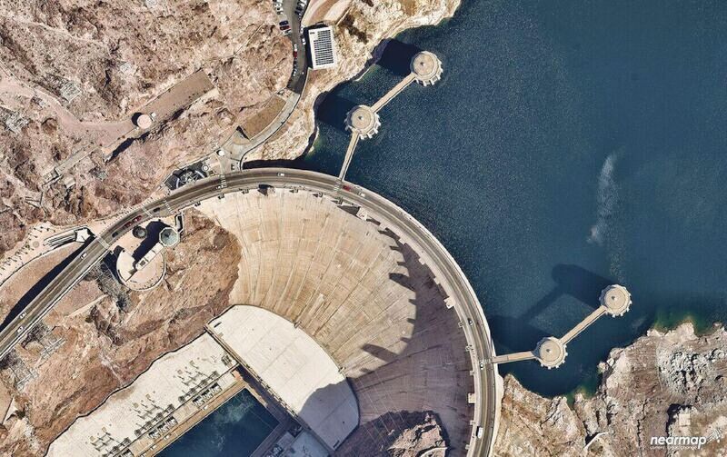
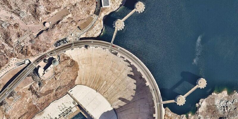
Nearmap high-resolution aerial imagery of the Hoover Dam at 2.8″ GSD.
Hydromax USA
In the UK, underground utilities data is hard to come by. Most of it is recorded in CAD formats and is diagrammatic. Some is recorded with better levels of detail, but the data is retained to ensure the work stays in-house. In short, if you want to do any form of underground work in the UK, you are going to have to do a lot of surveys before you get your hands dirty, which is why I was so surprised to see the work of Hydromax USA.
With almost 15 years under their belt, recording and analyzing the condition of the country’s aging water, wastewater, and natural gas conveyance systems, Hydromax USA has vast experience with new technologies and techniques that help contractors, engineers, and utility owners to make the best rehabilitation decisions regarding their buried infrastructure.
Hydromax is a testament to how current aerial imagery can transform a company. Having recently begun using Nearmap as an imagery supplier, they’re finding that they are able to do more accurate analysis.
Previously, the company used the imagery that came bundled with the GIS, but over time they discovered that it was often out of date and the resolution wasn’t good enough to make a determination on where an asset or piece of street furniture might lie–not good for a company that stakes its reputation on its ability to accurately record this information and then analyze risk.
With Nearmap, Hydromax went from using imagery that claimed to be 1″ GSD (although in reality was more like 5″ GSD) to using the Nearmap product that is better than 2.8″ GSD. It seems that Nearmap applies some sort of magic to the images, as they are not only clear and crisp but also very colorful and consistent.
Nearmap allowed Hydromax to make more accurate decisions so that they didn’t need to send field personnel onsite to do unnecessary inspections or send them to the same location multiple times because they’d missed something. Furthermore, by using Nearmap, which maintains a large historical data archive providing temporal data, Hydromax can verify assets using time-enabled analysis, therefore finding newly built infrastructure. One of the biggest problems in using a new imagery supplier, especially when your company has relied on the data supplied with the GIS, is consuming the new data within your GIS. Often the data is supplied on disk, and there are gigabytes if not terrabytes of data to manage. Hydromax laughed when I asked them about this!
You can use this high-resolution imagery like a basemap
They tell me that it was a simple case of adding the supplier WMS (web mapping service) to their GIS and using it with ArcGIS (for desktop and online webmaps). It tuns out that Nearmap runs a cloud streaming service, which means that you can use lightweight web protocol data in your GIS. And that means you can use their high-resolution imagery like a basemap. Genius!
Because the imagery is supplied as a streaming format and is so responsive, it has meant that Hydromax can focus on the analysis and predictive analysis. With this new level of accuracy and information, they have found that their product is far more cost-effective, and their customers are getting far better information for their buck.
Nearmap has found the right balance of location content, integration services, and ease of use with standard tools. Many companies try to reach these standards but never really achieve the whole package. Having tried their service, I can say that the data is beautifully clear and detailed enough for almost any scenario.
The ability to consume the data through a streaming service in almost any GIS is amazing, and the fact that the data is consistent means little in the way of artifacts or lines between images; everything appears so seamless.
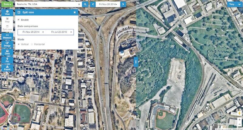
The MapBrowser user interface provides the ability to compare imagery over time to see change.