A roadmap for leveraging UAS for aerial mapping practitioners in the United States.
I often ask my clients if they’ve had a conversation in the last 24-48 hours where the use of drones has come up. Invariably, they chuckle a bit and answer, “Yes.” Virtually all professional conferences in the geospatial industry have numerous presentations on UAS technology and its applications. Like any new, disruptive technology, the hype is significant.
In its 2015 Hype Cycle for Emerging Technologies report, IT research firm Gartner places “autonomous vehicles” near the apex of Peak of Inflated Expectations. Over the past 3-4 years it has been climbing that curve, and you can be quite confident that we’re headed for the Trough of Disillusionment. How far we dip and when it recovers, only time will tell.
Although disillusionment will come, there are still many viable applications of the technology today. The intent of this article is to temper expectations through a solid understanding of when and where UAS are appropriate and outline eight keys to success for leveraging the technology.
When Appropriate?
Our first order of business to utilizing drones effectively is to understand when and where they are appropriate. Given the complexities and vagaries in the UAS market, it seems like a good time to deploy a mnemonic device: look for a “losirr.”
Although tongue in cheek, this acronym comes from the perspective of a traditional photogrammetrist who is accustomed to utilizing manned aircraft. For UAS to be relevant for your project, be prepared to say “yes” to at least one or two of these items.
L O S I R R
Local
For UAS to be cost-effective, they often need to be located reasonably close to where the project site is. There are exceptions, but generally the technology will not be cost-effective if we have to put an operator, an observer, and all their gear on an airplane, fly them to the job site, and cover their expenses while there.
Out of reach.
UAS are great when your job site is in a tough-to-reach location where other technologies such as fixed-wing or rotary-wing manned aircraft or terrestrial scanners are not feasible. Examples include canyons and rock walls with tight vertical and horizontal clearances or near infrastructure such as bridges or cell towers.
Small
Sites of more than a few hundred acres are typically difficult to justify using UAS. They require more flight planning and field time to acquire, but, more importantly, there is a significant increase in image processing time and resources to derive the desired image and map products. As a site gets larger, you can mitigate those challenges by adjusting flying heights and ground sample distance, but you may quickly find yourself in a situation where a manned aircraft is a more logical approach.
I can collect.
A major draw of UAS technology is that it is democratizing the process of imaging our world. At present, a licensed pilot is required to operate the UAS when done for commercial purposes, but there is a good chance that this will likely soften when the FAA formally acts on the Small UAS Notice of Proposed Rulemaking (NPRM).
Resolution
We all want higher-resolution imagery, although what really matters is the size of the sensor in the camera. With UAS, we can achieve exquisite levels of detail in our imagery as we adjust the flying height and the sensor in use. A ground sample distance of <1 inch is quite common now and opens up new applications that require that level of detail. However, it comes at a price as lower-altitude flights exacerbate challenges such as controlling the imagery to derive map products with an absolute accuracy and the level of resources needed to process thousands of images.
Repeat
UAS offer the ability to revisit a site multiple times over the course of a project. Site monitoring for seasonal change detection, safety, resource allocation, and status reporting during construction or volumetric changes for asset inventory or site remediation are all good use cases for revisiting a site. Revisits such as this via a manned aircraft are often cost-prohibitive.
Keys To Success
If you have a “losirr” site, follow these keys to successfully leveraging UAS in your organization.
1) Refine Workflows for Geospatial Data Production
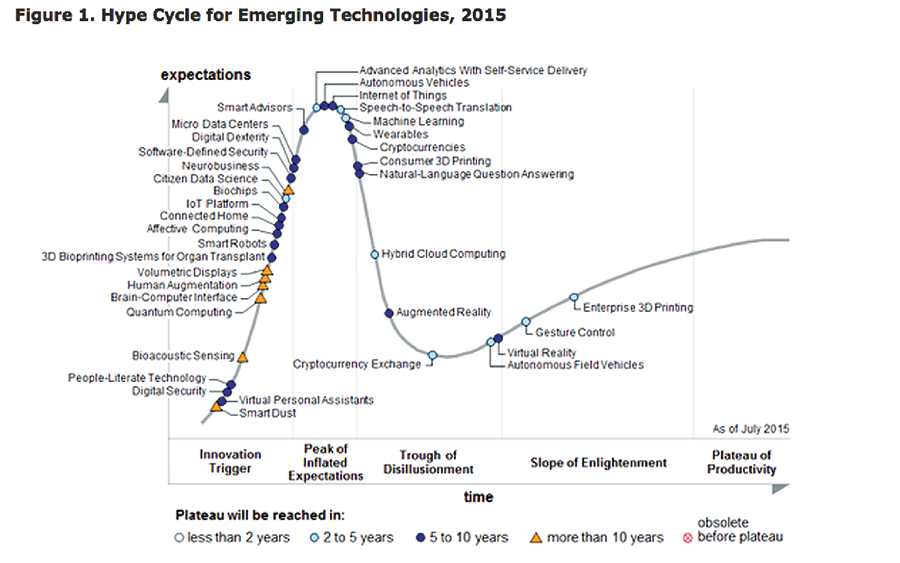
Gartner’s 2015 Hype Cycle for Emerging Technologies
Humor me for a moment, and let’s jump ahead to product generation. The largest challenge in the UAS market today is the inability to deliver geospatial products that have verifiable, absolute accuracies. The accuracy of geospatial products is significantly affected by non-metric cameras with significant lens distortion, highly variable ground control quality, varying implementations of Structure from Motion (SfM) and semi-global matching (SGM) algorithms in software, and numerous software options.
In addition, software tools do not provide true bare earth surfaces (when vegetation is present) or planimetric mapping of any kind. Be prepared to refine your workflows significantly to achieve results with absolute accuracies. Deriving such products requires a great deal of extra work and often accounts for a significant portion of a project’s time and budget.
2) Familiarize Yourself with Small UAV Platforms
There are literally 1000s of small UAV platforms available, ranging from fixed-wing to rotary-wing, open-source to commercial, consumer-grade to professional. Keep several things in mind if you are building out a UAS practice:
Be prepared to maintain a fleet; you will find that you need more than one UAV. Rotary-wing and fixed-wing units offer different benefits and capabilities. Even with proactive fleet management, mechanical failures occur. Also, you will likely want a UAV local to the job site and with the appropriate sensor configuration.
Redundancy is essential. Your UAVs should all have backup systems to ensure safe and reliable operation. Consumer-grade UAVs typically have GPS only, and without six or more satellites it will automatically transition to manual flight mode, and your autonomous flight is out the window. Your production UAVs should have a professional-grade GPS hardware that receives a signal from both the U.S. GPS constellation as well as from others such as the Russian GLONASS system or the upcoming Chinese system BeiDou (also known as COMPASS).
Get spare parts. UAV components wear out and are prone to damage due to hard landings or accidents. Understand the costs and availability of those parts before committing to a UAV product line.
Understand maintenance procedures. You must have a clear understanding of how to make repairs on your UAV fleet. Current FAA regulations allow for self-certification of airworthiness, which gives you some breathing room, but your business is at risk if your units are not adequately maintained.
Evaluate your UAV warranty and support program. There are plenty of stories of organizations suffering from a catastrophic loss due to mechanical failure or pilot error. It is not a matter of if; it is a matter of when one of your UAVs will be damaged. Understand your UAV manufacturer’s warranty and support program.
3) Develop a Standard Operating Procedure (SOP)
A thorough SOP ensures that all UAS field crews will operate in a safe and similar manner. An SOP is also critical to obtaining a 333 exemption and certificates of authorization (COA) for specific flights. The SOP should contain all checklists for pre-, during-, and post-flight operations. It should also discuss how you train your operators, safety protocols, and roles/responsibilities for both the operator and visual observers. Train on it and review it annually.
4) Select and Train Operators Carefully
A good UAS operator needs strong knowledge in aviation gathered through training from your UAV manufacturer(s), ground school or aviation classes, and/or a degree in UAS from one of numerous schools in the U.S. Drone Training HQ (dronetraininghq.com) provides a list of schools that offer various UAS programs for pilot training.
All UAS operators and visual observers should have a thoroughly vetted understanding of general aviation, including airspace requirements, communication protocols, the Notice to Airmen (NOTAMs) process, emergency procedures, and sense and avoidance. Document these procedures thoroughly and review them annually. Strictly enforce the use of field notes and data capture. Train your UAS staff on corporate policies for flight including no flying under the influence of drugs or alcohol or without appropriate sleep.

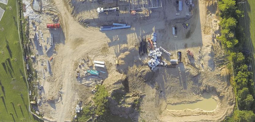
Point cloud and ground control for a bike path redesign; imagery was flown via UAS.
Ensure that all project staff knows that the UAS operator’s word is final when it comes to putting the UAV in the air. Finally, ensure that your UAS operators have a strong dedication to professionalism, attention to detail, and an ability to stay cool under pressure.
5) Understand Current UAS Regulations
UAS regulations are a challenge. For commercial fliers, a 333 exemption and a licensed pilot acting as the pilot in command are required. The Notice of Proposed Rulemaking (NPRM) for commercial use of small UAS is still under consideration. Best case scenario is that rule 107 will be in place by late 2016, and it will likely include a UAS operator certification as opposed to requiring a licensed pilot, as well as operational limitations that include flying within visual line of sight of the operator, under 500 feet, during daylight hours, and not over people involved in the operation. (For more on regulations, see “The Space In-Between.”)
6) Practice Flying
Consider having your operators practice on a simulator (20 hours minimum) before their first flight, and then use it to allow your UAS operators to keep their flying skills fresh in the winter months. I recommend utilizing a consumer-grade UAV for practicing manual flight skills. Test flights with the full system are also critical as challenges can arise with communications or base station failure. If you change something on the UAV, perform a test flight and document the results.
Don’t forget to have each operator log flight hours, too. This best practice will assist you in obtaining insurance and may be requested by the FAA at some point.
7) Get Insurance
A good rule of thumb is to budget $2,000 per year to get $1M in organizational liability coverage for each unit you are flying. To get hull insurance for the unit itself, you will likely have to document that your operator has 100+ hours of flight experience on that platform. Remember the log book! This coverage is typically another $2,000 per year depending on the value of the unit.
8) Get Good at Data Management
UAS adds to the challenge of large dataset management. It is commonplace to generate 200MB per minute of data from one UAS. That can easily increase to 2GB per minute when shooting video or collecting data from multiple sensors. A UAS crew operating one unit for four hours per day would generate nearly 2TB of data per week. In addition, interim and final derivative products can increase your data needs by an order of magnitude.
The UAS market is evolving quickly, and with it are expectations. Remember to utilize UAS only when the project requirements call for it and verify the accuracies that are claimed. Purchase wisely, define your SOP, and train your staff. Fly safely and good luck!