
Esri has announced Site Scan for ArcGIS—an end to end solution for UAV data capture.
This year, at the User Conference, there was a buzz around drones (see what I did there), a rumor was going around that a new drone solution was being announced. Sure enough, during the plenary, Jack Dangermond, Esri co-founder and president, mentioned something called Site Scan, then just left the words floating in the air…

Demo flight over Esri’s HQ in Redlands California
So, what is Site Scan and what is it used for? I did a little research—and we heard more during the remaining days of the UC—this is what I found:
ArcGIS is a comprehensive imagery platform which encompasses map production, analysis & AI, visualisation and exploitation, image management and content. Site Scan allows for the flight planning, also capture and production of UAV data.
Site Scan for ArcGIS is part of the ArcGIS Drone Collections which is now the only end to end drone data platform which gives users the ability to process imagery in the cloud so you can scale you drone operations. A comprehensive fleet management system allows you to track pilots, hardware and projects in a centralised location.
Users can manage their complete drone workflow with Site Scan, they can firstly plan and capture data using the Site Scan Flight Planning Application (iOS) using advanced flight modes, then process, manage & analyze the data in the cloud with Site Scan manager. Once this is complete, the data can then be disseminated in the ArcGIS platform, either online or on desktop.
The flight planning application is an iOS application that creates safe and repeatable flight plans, suitable any size and plan. It behaves as a flight manager in the field and allows users to check FAA checklists or custom self-defined checks as well as receiving in app flight space warnings.
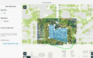
Flight planning in the Site Scan app
Within the app, it is possible to visualize the flight path but also fine tune flight parameters (min/max height and others) also it is possible to see whether there is compliance with the company flight policies.
Once the flight is complete, it is possible to immediately start QCing the images through the app without having to take the memory card out of the drone since it is wirelessly connected. If happy, you can then send the data to the Site Scan Manager and even get a notification once it is ready.
Site Scan Manager allows processing of imagery in the cloud, track and manage pilots, hardware and flights, Overlay GIS and CAD layers and publish data to ArcGIS online and Enterprise. It uses structure from motion to create GIS ready products. Because it leverages the cloud processing, it is scalable and robust.
There are two Ground Control Point (GCP) workflows, a little like the georeferencing in ArcGIS Pro, there is manual GCP tagging or automated GCP detection, this method likes the checkerboard targets, though you may spray/mark crosses across the site.
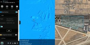
A surface created in the cloud from the captured images
Some of the products that may be created using Site Scan Manager are orthomosaics, digital elevation models, surface models and 3D point clouds and meshes.
There are a few great touches in this tool, the manager, which shows which drones have been used, their serial numbers, how many flights and times they have performed is a great resource as you can even monitor how much flight time certain drones in your fleets have logged.
Brief video intro posted by Esri during the UC.
It would be awesome to use this out in the field to see if it lives up to expectation!