Derek Baxter answers on how high-precision UAS mapping enables workflows for the future
We’re coming up on nearly a decade of professional and pro-sumer small UAS applications for AEC and other industries. You’ll find a UAS in the toolboxes of many surveying, construction, and engineering teams, which do not give a second thought to launching one for nearly any kind of project. But you’ll also find firms that have gotten a taste of UAS potential with the pro-sumer models, that are now at a point where they need to upgrade and refine workflows.
One such practitioner is Derek Baxter, senior surveyor with Johnson, Poole and Bloomer, a prominent surveying firm in the UK. JPB has served mining and civil clients for over 150 years but only embraced UAS two years ago. Nevertheless, the company has polished and perfected its workflows to provide rapid and cost-effective volumetric data for clients.
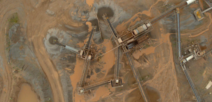
“We use the UX11 [UAS] on mines and quarries; presently about 90 percent rock quarry sites,” said Baxter. “Clients are liking drones more and more from a health and safety point of view–not having us walk near faces and around machinery–but also to save a lot of time. We can do the work right away, not like with GPS or surveying. Overall, a fantastic piece of kit (new equipment), and we are really happy to use it.”

JPB has refined a multi-step workflow for the UAS data to take advantage of strengths in each subsequent software used. The raw data from the flight is ported from Delair’s After Flight to Trimble Business (TBC) where images are combined into JXL files for processing in Trimble UAS Master
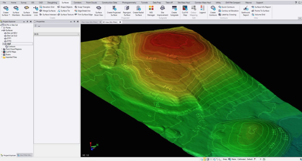
Note the flight lines, ground control points (GCP), and photo points. Tie points and orthophotos are generated, minor adjustments made, clouds merged, and then export back to TBC for 3D model generation (below), digitizing, and design work.
Adding Services and Skills
In a written history of JPB, it is noted that in the mid-19th century, when founder and noteworthy English surveyor Henry Johnson began his career: “After five years’ apprenticeship the young surveyor could turn his hand to anything from mapping estates to framing pictures, dialing and leveling in the mines, valuing property and even drawing the bodies after a pit disaster.” The many careers for surveyors, the tools they used, and the services their firms offered, only increased. Derek Baxter, who has a civil engineering background has worked in construction layout, water surveying, tracing out utilities, railway, and then mineral surveying, joined JPB in 2018 when the firm was first implementing UAS.
“I had not used drones before coming to JPB, and we’d just started using them then,” said Baxter. “In 2019 we used (drones) on over 25 sites, and probably more this year.”
JPB, Baxter explained, had experimented with small rotor UAS, and a fixed-wing UX5 (predecessor to their current Delair UX11). “Rich (Kenyon, associate director at JPB at the time) did a lot of testing and set up procedures. Some of us attended a drone pilot academy, and we compared the plane drone with a rotor one a colleague was using. The rotor drone has such a short flight time, and we’d have to do so many flights to cover large sites, swapping batteries all the time, the [fixed-wing UAS] makes so much sense for us.”
The Smooth and the Rocky
“Some quarries are for rock, others for sand and gravel, and there is not always a soft place, like grass, to land on,” Baxter said. “The UX11 has polystyrene body, it lands on its belly and we have a belly replacement, but have not had to change it. When you land into the wind you kind of lift at the end, like a stall, and it gently lands on the belly. The hardest thing we’ve landed on is compact sand, not concrete. Grass would great, but as you can imagine we don’t have that around a quarry. It’s been great for us so far; no issues with landing or ripping apart. That is always a positive.”
“We didn’t always have a great place to set up the catapult to launch the UX5. The UX11 is hand launch; you kind of chuck it like a Frisbee, so we can do that just about anywhere,” said Baxter. JPB was eager to upgrade to the UX11, and as local distributor Nick Smart, technical sales consultant at Surveying Solutions Group explained, “JPB took delivery of the UK’s first Delair UX11, it was a learning curve for all of us but it has been a joy to support Derek Baxter and the team over the last couple of years.”
Baxter identified one drawback with fixed-wing UAS, though they do not often encounter this limitation on quarry sites: “When it comes to the end of a flight line, it has to go further to loop back for the next line, and if the edge of the site is up against a housing area, we could be restricted. That is one situation where the rotor drone might be better.” This is a universal issue, and there have been firms that have had to fly part of the site with the fixed-wing craft, giving a buffer to turn around short of the restricted area, and filling in that buffer zone with a rotor craft.
Work Flown and Workflow
JPB has deployed its UAS on sites large and small. “We can do some with a single 10-minute flight, but we’ve just done one that was 2.5 kilometers long and a kilometer wide. (It took) four 35-minute flights,” Baxter said. “One site took 10 flights; an opencast site that had been restored to grass areas and the client wanted a final level check–that was 17,000 images. We’re preparing for a 15 flight, 27,000 image one soon.”
Baxter said that operation of the UAS is in some respects the easy part. Designing the workflow took quite a bit of testing, but now the company has it down to an art. “We like to set out as many [GCP, ground control points] as possible,” Baxter said. “We set these out with our R8 [Trimble GNSS rover], but I also set up a base. Just in case we miss a control point, or someone has kicked it or some heavy equipment has torn it out, then I can do PPK [post processed kinematic] with the base data.”
“We select the area from the Google map in the app, input the wind direction, and look at the flight lines,” Baxter said. “We get a brief view of the photos it has taken, to make sure we got everything in the field and don’t have to go back. We put the control points in to [Trimble Business Center] TBC and then we drag in the drone data that we’ve processed in [Delair] After Flight. We can put more than one flight together in After Flight and export as one JXL file, or do several if it is a large site, then we bring that into TBC.”
From TBC, the data ports to UAS Master [Trimble], “generate tie points, and do some minor adjusting,” said Baxter, “and generate a single orthophoto and merged point cloud, then back into TBC where we do digitizing and design work.”
Quarry and mine clients are mostly interested in volume, and volume change totals. So, Baxter says some of the deliverables are simply Excel or text tables. Clients have found the ortho images to also be useful for many more purposes than the originally envisioned–asset management, safety, change detection, etc. With the TBC CAD functions, JPB techs identify top and bottom of face, draw up stockpiles. Baxter said. “We export to DXF to use in LSS [a UK originated modeling software for AEC] that we are really comfortable using; it is really good for finding break lines and making a DTM. We plot it all up in LSS and deliver to the client with tables.”
While Delair has end-to-end solutions (more about that later), JPB’s workflow though several software packages–that might seem like a lot of steps–makes the most sense as each step is so well refined.
Software and Hardware Agnostic
Impressed by JPB’s refined home-grown software amalgam workflow, I wondered if Delair minded that its client was not using Delair’s end-to-end solutions’ These include a cloud processing service, even workflows and advanced analytics designed specifically for mining, construction, aggregates, etc.
“Not at all,” said Chase Fly, Delair’s geospatial product manager. “We are proud to offer an end-to-end solution, something a bit unique among UAS vendors, but we also see the value in being pretty much software agnostic. Besides supporting a Trimble workflow with the JXL output for TBC, we developed a cloud-based data processing platform called Delair Aerial Intelligence, or delair.ai, where we integrated Pix4Dengine, Agisoft Metshape, and Bentley Context Capture. Different use cases, different clientele preferences or requirements.”
Long gone are the days of UAS vendors simply selling UAS as platforms, though the UX11 is Delair’s flagship UAS and most readily recognizable product. They also partner with other sources on rotor craft. Their UX11 is from the lineage of the pioneering Gatewing fixed-wing UAS; that for many users heralded the advent UAS for AEC and other industries.
xyHt attended a Gatewing training school in Canada in 2012 (when UAS were still pretty much prohibited in the U.S.: bit.ly/2JfCg7Z). The Gatewing X100 begat the UX5 (when Gatewing was bought by Trimble) and then, when subsequently acquired by Delair, begat the UX11. Fly says that the customers are not bound to the hardware, they can use Delair’s cloud services and much of their software with data collected by on nearly any platform’in that sense they are hardware agnostic as well.
Trends and Challenges
One interesting point that Fly says gets lost in conversations about UAS trends, especially for AEC, is “everyone talks about getting to an ortho photo, raster DSM, point cloud, etc. Surveyors care more about linework and deliverables. That’s where there is a learning curve. To operate and process UAS data is becoming increasingly easy to master, but folks struggle with the deliverables–and some get disenfranchised largely because of workflow issues. The photogrammetry part is more of an art than a science.”
The photogrammetry steps tend to make some surveyors uncomfortable. Fly notes that the control points are brought in–positions surveyors accept as gospel–but then the UAS data gets moved around to fit. While that is simply a step in producing a deliverable of uniform, but not necessarily lower, precision and accuracy, it can be an unsettling concept to get used to.
“Drone people didn’t often get that the customer deliverable has to be more than the sexy image or point cloud, but ultimately need to deliver planimetry,” said Fly. “There is a knowledge gap between the production of photo, or scan, and deliverables.” Good cloud jockeys, who have mastered extraction of features and planimetry are hard to come by, and there has been a bit of overselling of “automated” detection, classification, and extraction solutions in the geospatial community. For surveyors, developing refined workflows, as JPB has, may be the key to closing the gap.
“One of the areas TBC, and office software like it, comes in strong and is perhaps undervalued, is that many surveyors already have it, and are doing planimetry with it on terrestrial data. They just have to learn how to do it with point clouds,” Fly said.
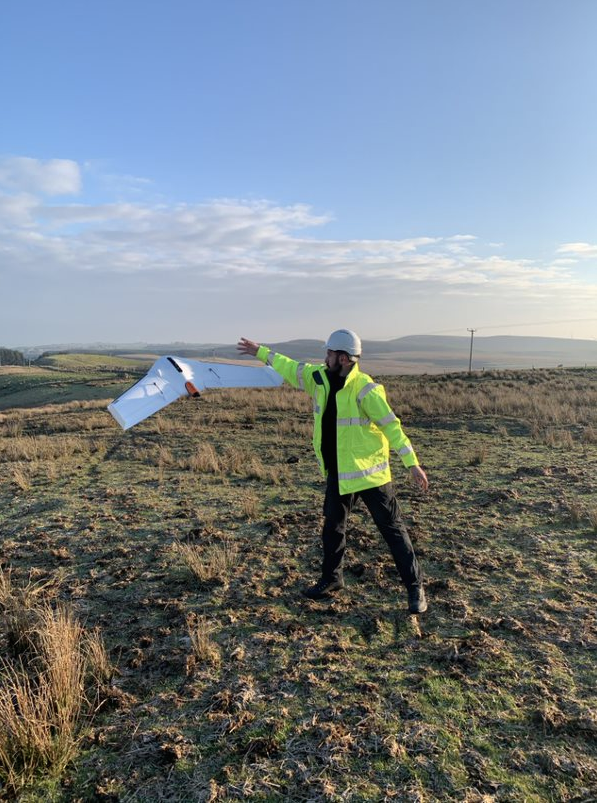
Derek Baxter, senior surveyor with Johnson, Poole and Bloomer, in Glasgow, Scotland, shows that launching Delair’s UX11 mapping drone is almost as easy as throwing a Frisbee.
Broader Use for AEC
Brandon M. Thompson, a licensed surveyor, is Delair’s support manager for the Americas. He has been looking at adoption trends for various industry segments, including AEC.
“We have strong software tie-ins and a cloud-based solution marketed for mines and aggregates–it makes lot of sense,” said Thompson. “Throw it in the air, and your get rapid stockpile data. But as we are also marketed though Trimble dealerships, we are seeing more usage for surveying and construction.”
“Orthos are becoming more and more a standard deliverable doing surveying and mapping, for topos, ALTA surveys, etc. It is easy and inexpensive to add a UAS flight to just about any survey,” said Thompson. “Many folks got a good taste of the potential for value added, buying consumer drones from [big-box stores] and using common processing software or service. We find many of those at that stage in the maturity of drone market outgrowing their little starter.”
“They go to dealers and discover sophisticated units,” said Thompson “But, it’s not just hardware, it also software solutions that come with connected workflows.”
I have also observed that in many other parts of the world, surveyors are increasingly upgrading to more serious models and systems. Sure, the low-cost starters provide comfort in knowing that even if there is a crash, the cost of replacement is lower, but as users become more experienced in operations and are less prone to mishaps, moving beyond the limitations of the starter solutions holds more appeal.
“For larger sites, from landfills to water systems, communications networks, transmission lines, long right-of-way corridors, small rotor drones are not well suited for these,” said Thompson. “And it is not just the limited flight time, it is also the comms. You are limited in the effective range of control by the radio. We have an effective flight time of 27 linear miles (about 40 km), and that could not be done with a radio. You’d have to do it by moving forward in sections like a conventional survey. We’ve integrated 3G cell, so that as long as the whole corridor or area was in cell coverage, you would not have radio distance limitation.”
This would make it possible to do some beyond-visual line of sight (BVLOS) projects. Obtaining BVLOS permits or waivers is problematic, not so much in Europe or some other parts of the world as in the U.S. It continues to be a challenge, and those waivers that are approved are often very specific legal language dependent. While we see more BVLOS waivers being approved by civil aviation authorities, these are still mostly limited to large industrial concerns at this time.
Going back to Baxter’s concerns about flying above populated areas, there has been progress in waivers for flying over people. Beyond some sticky privacy issues in some jurisdictions, one key concern is a drone falling from the sky on someone. Said Thompson, “For a rotor drone, they have to address that by adding a parachute. With our fixed wing, it is very light, and can glide and continue to be controlled if it loses power. This has been helpful in some waiver situations.”
Rock On
JPB has a great workflow figured out; well suited for its customers’ needs. This is a great example of deliverable-centric drone workflows. After all, it is the deliverables the client is most concerned with.
Utilizing purpose fit UAS hardware and end-to-end or amalgams of software, workflows can be refined to yield benefits not only in specific 3D data deliverables. Lateral benefits are in safety, environment, and with by products like orthos that can be used for many more purposes. As Baxter said:
“It’s the way forward, basically that’s the way I like to say it.”