UAV digital monitoring delivers significant benefits as part of a major German tunneling construction project.
The German city of Karlsruhe plays a decisive role in transport planning in the southwest of that country, with more than 300,000 inhabitants, 160,000 vehicles in the main part of the city, and 190 million train passengers every year.
Highway A5 influences the planning scenarios in the greater Karlsruhe area as well as the inner-city use of the state street B10. This is the most important inner-city, east-west connection for the region.
The city of Karlsruhe as well as the federal state of Baden-Wuerttemberg have responded to increased traffic in the whole region by launching two exceptional tunneling projects called The Combined Solution, which will help to significantly alter the traffic situation in the inner city starting in 2020 and 2021.
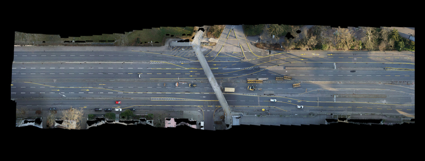
The corner of Kriegs Street, Fritz-Euler-Street, and Kapelle Street, including multi-track railway crossing.
Large-scale projects like this come with concerns from citizens. Construction noise, disruption of daily life, costs, pollution, and environmental restrictions are only a part of the potential issues that must be taken into account.
The city government and the Karlsruhe Rail Infrastructure Society builders have set up a long-term and early information campaign for this purpose. The campaign has taken the form of a project website as well as public events and an information center.
The aim of the builders, as well as of the participating construction companies and consortia, was also to make the best use of digital solutions for construction-site documentation.
Highest Accuracy
The construction companies Ed. Zublin and Schleith are responsible for the construction of the Kriegsstrassen tunnel next to the Ettlinger Tor. This means that vehicles are brought below ground, while trains, pedestrians, and all bicycles move above ground.
On a path of 1,600 meters, the road tunnel dramatically changes the cityscape—as well as the construction work. The construction planning and subsequent supervision take on special importance for this reason.
The objective of the construction supervision cooperation, consisting of DB Engineering & Consulting, Emch+Berger, and BUNG, is to obtain:
- the highest accuracy in surveying,
- the preservation of evidence, and
- accurate monitoring.
Before work could begin on new construction sections, the construction area had to be surveyed as well as an area of 50 m along all side streets. The expected accuracy of the data was 2 cm.
This task was taken by IngenieurTeam GEO using an unmanned aerial vehicle (UAV) by Leica Geosystems. (A new Leica Geosystems UAV solution will be announced at HxGN LIVE in June.) Equipped with the RTK and GNSS module, this technology allows airborne data to be collected parallel to the on-site operation, delivering highly accurate data by combining the HP GNSS 2 and the Sony Alpha 6000 with a 20 mm lens.
City Challenge
As is customary in the case of a tunneling construction site, the construction must not lead to unplanned changes in the environment. Any reductions or unwanted volume changes must be excluded, and this exclusion has to be documented and monitored. Conventional methods can only be used to a limited extent in parallel to construction measures because of security and time constraints.
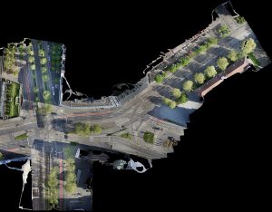
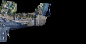
The use of a UAV was recognized as an optimal solution for capturing data due to its efficiency. The advantages of its 3D measurement and monitoring compared to purely point-based data acquisition using terrestrial methods are in the various usage scenarios of the generated data in particular.
They not only answer questions from a surveyor’s point of view, they can also be used as a basis for planning traffic routes during construction work. They can be used in pre-planning and retrospective-construction planning and are a decisive factor in volume calculation almost in real time.
Challenges of flying in the city center are significant, however. The narrowness of the city has to be taken into account in the flight planning, and, therefore, the flight route and altitude planning has to be defined specifically. Potential disturbances of the flight by cranes, vegetation, and possible magnetic field disturbances due to the existing infrastructure and development also play a role.
Around the project, the Federal Court of Justice and the Karlsruhe State Theater are critical buildings.
Benjamin Busse, an expert in the use of surveying drones at IngenieurTeam GEO, has therefore placed special emphasis on the involvement of all stakeholders during the planning phase.
“The new drone regulations in Germany do not allow flights over federal streets,” says Busse. “Thanks to a good relationship with all stakeholders we got special permission for the inner-city flights over the B10 with traffic, pedestrians, and tram.”
Digital Results & Economic Benefits
The deliverables for the project included:
- classical orthophotos,
- high-resolution single images for documentation,
- digital elevation models, and
- point clouds.
The inspection of traffic route planning was also mandated. This took place on the basis of existing plans that were combined with the information from the orthophotos.
As a result of the data from the flights and the high-quality information, quarterly monitoring was planned for critical volume calculations as well as a supplement to the construction site through videos and photos from a bird’s eye view, with the help of UAV solutions.
An orthophoto of the corner of Kriegs Street and Ritter Street, showing the Lamm Street construction site and traffic re-routing on the day of the demolition of the bridge.
With conventional measurement and surveying methods, not only significantly less data could be collected, but a team of five people would have needed six weeks to deliver the desired results. The team of two people for the UAV workflow needed only seven days.
Conventionally, Leica Geosystems total stations were used. The UAV team worked with a Leica Geosystems UAV solution, the Sony ILCE-6000, the HP GNSS 2, as well as a Leica Viva GS15 GNSS smart antenna for measuring the ground control points.
The costs for the client using the conventional method would have been 180% higher than working with the UAV solution. The monetary perspective is even more attractive from the UAV operator’s point of view: the costs for IngenieurTeam GEO using the UAV solution were only 1/5 of the costs of conventional methods.
“We see the UAV technology as part of our tool box,” adds Martin Schwall, co-founder and managing director with IngenieurTeam GEO. “From a customer’s point of view, a UAV allows fast and digital results with many advantages for additional information.”
Digital Workflows
The digitization of the processes associated with construction projects always depends on high-quality data and density. For example, the information from the UAV flights can be used not only for planning and monitoring but also for machine control and project communication tasks. In a further development, the data of the UAV will also be seamlessly integrated into the software solutions of Leica Geosystems.
The results are not only faster but also can be customized to meet individual requirements with little effort. While conventional methods generate selective data, they do not capture image data and therefore do not allow digital visualization. The use of a digital end-to-end solution based on UAV, corresponding sensor technology (here a high-resolution RGB camera), and suitable software for post-processing and data processing offer real benefits, such as:
3D measurement information,
- option of a parallel inspection based on the image data,
- data capturing parallel to the day-to-day business, and
- much higher safety for the local surveyors and UAV operators.
The generated data is the basis for answering existing and future questions and will help with archiving all construction progress from the first day.
“As a next step, Leica Geosystems will fully integrate the UAV solutions in the software solutions for construction, monitoring, and surveying,” says Valentin Fuchs, Leica Geosystems UAV product manager. “Helping our customers to visualize information and to use the collected UAV data to automate and speed-up processes is part of the bigger picture of future developments.”