All posts by Gavin Schrock
Alasdair Begley
Alasdair Begley – Director – Saunders Havill Group – Australia Alasdair Begley views the design and development of commercial and public projects in a holistic manner and develops solutions to challenges— approaching each as integral parts of the design process rather than compartmentalized independent tasks. And with his bachelor’s degree in surveying from the Queensland University of...
Gus Porter
Gus Porter – Vice President, Sawtooth Land Surveying – Idaho, USA Gus Porter views change as an opportunity, not only for his company but for his profession. Gus is a third-generation land surveyor who began surveying during his school breaks at the age of 14 and started his company with his dad. He says he’s been fortunate to...
Morgan Ré
Morgan Ré – High school student intern at NASA – Virginia, USA Morgan Ré attends both governor’s school and high school in Virginia; she’s on track to graduate with an associate’s degree in May before graduating high school in June 2015. She’s been interested in working for NASA since sophomore year when she began at Virginia...
Lily and Sarah Jenkins
Sarah and Lily Jenkins – Student Science Award Winners at Molokai High School – Hawaii, USA Featured in the keynote address of the 2015 Esri user conference were high-school siblings Sarah and Lily Jenkins. Their team won an international science competition for their geospatial analysis of the “March of the Molokai Mangrove” on how the invasive non-native...
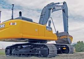
The Digital Site
The complete digital site is more than just machine-controlled heavy equipment. Recent advances in heavy civil have been profound in connectivity, automation, and visualization. How long has automation played a role in heavy civil construction? As far back as the late 1980s when early GPS-guided (or informed) systems began to reach the market. But it...
Autodesk + Leica Geosystems
Two tech giants embark on a collaboration and education outreach. At June 2015’s HxGN LIVE (the annual user conference for Leica Geosystems and other divisions of Hexagon), we spied something rather surprising: an Autodesk booth. What’s more, someone at the booth was using Autodesk software for construction layout on a consumer tablet, driving a Leica...