All posts by Gavin Schrock
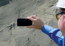
Stockpile Reports
How to do enterprise inventory management from image-based 3D reconstruction, in the cloud and in your pocket. “No one wakes up in the morning thinking that they need to buy a point cloud,” says URC Ventures CEO David Boardman. “Most people would be thinking that they need to solve some business problem.” What URC Ventures...
xyHt’s 40 Geospatial Leaders under 40
Join xyHt in Celebrating Young Leadership in Geospatial Professions, Industries, and Sciences! Who are the current young geo-leaders internationally? And where are they making a difference? There is a maxim: “We teach children their future, and not our past.” With the exception (in the geospatial realm) of archaeology, forensics, monitoring, and boundary survey (where historical...
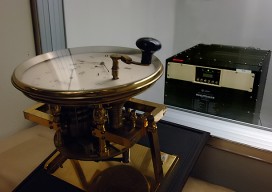
The Clock(s) at the Center of the Universe
To provide precise global time, critical to our digital world, the United States Naval Observatory serves as the major node in a worldwide array of synchronized atomic clocks. For all but a relatively few astronomers and scientists, the universe of humans centers around our earthbound activities and our heuristic sense of time – day, night, seasons,...
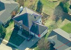
EagleView
The practical side of on-demand aerial image analytics, with an interview of CEO and president Chris Barrow. A contractor showed up at my house to give an estimate for a long overdue roof replacement. He hadn’t pulled out a ladder, so I asked if he needed mine. His response was, “Since we started using EagleView,...
Feature: Hydrographic Research and Development
From Science and Engineering to Your Hydrographic Toolkit “The complexities of and incubation times for advancing instrumentation are often not fully appreciate ”—T. Curtin, E. Belcher, Innovation in Oceanographic Instrumentation (2008) Extraordinary—yet mostly unseen—innovations continue to shape the tools surveyors use on water and land: innovations in science and engineering for hydrography, oceanography, robotics, and global navigation...
PPP: IGS Announces the Launch of RTS-IGS
If anything underscores the fact that high-precision, global, real-time GNSS is real, viable, and here for the long run, it is the news that the International GNSS Service (IGS) has launched an open access real-time precise-point-positioning (PPP) service. While a few years behind some commercial (and sometimes proprietary) real-time PPP services, this international cooperative of...