All posts by Linda Duffy

New Digital World Needs Data
Next-generation surveyors require specialized education and training to fill the role of geospatial data specialists. Many emerging geospatial applications, such as digital twins, 3D modeling, monitoring, virtual reality, and autonomous vehicles, are based on big digital datasets. Building a 3D digital world starts with accurate data that ties to a point on the ground, so...

The Ocean Mapping Imperative
Wind and solar-powered uncrewed surface vehicles offer a boost to global surveying efforts. Since 2017, the Seabed 2030 initiative has raised awareness about the importance of mapping the entire seafloor to support a healthy and resilient ocean for the well-being of the entire planet. This partnership between the Nippon Foundation, the International Hydrographic Organization (IHO),...
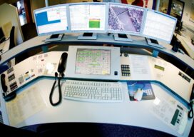
Upgrading GIS for a Better 911
The complex system of emergency call routing and critical location data delivery is getting a makeover Minutes can make a difference between life and death for 911 callers. A quick response with suitable equipment and knowledgeable personnel is the goal of 911 call centers across the country. However, managing calls and texts from mobile phones...

Easing Post-Disaster Pain
High-resolution aerial imagery of the Colorado Marshall Fire burn area expedited insurance claim process. With a long career in emergency management, Richard Butgereit is well aware of the devastating impact of natural disasters; however, his normal role is monitoring the event from afar and facilitating the assistance needed afterward. On December 30, 2021, in suburban...

Blowing in a New Direction
A new market is emerging for aerial mappers as investment in renewable energy grows Public and private utilities are focused on diversifying their energy portfolios after years of research and testing have improved the efficiency and reliability of alternative power generation methods. Support for the development of clean-energy options has never been stronger, creating an...
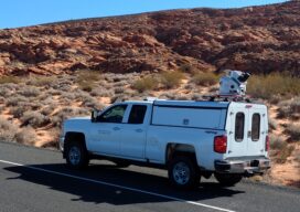
Lidar and Surveying: Infrastructure Relies on Surveys
Mobile lidar platform provides engineering firm with data sets for multiple deliverables In the past, project teams couldn’t get high-quality, actionable data quickly when performing surveys—there was always a trade-off between time and quality. However, advances in mobile lidar technology are significantly reducing the time it takes to collect data while still meeting strict accuracy...