
Blog
Mahtab Moteab
Geospatial Data Analyst, Geocurve Ltd. Kelvedon, UK Mahta Moteab began her geospatial career with an associate degree in civil engineering technology at the Technical Faculty of Surveying, Tehran, then a Bachelor of Surveying Technology at the Darolfonoon Institute of Higher Education. She has worked as a cartographer, and in photogrammetry as technician, and then as...

Geo Week 2019: Lots and Lots of Lidar
Every time I go to this conference I get the sensation of drinking from a fire hose: so much lidar technology! This year the International LiDAR Mapping Forum (ILMF) became Geo Week with the addition of the ASPRS annual conference and MAPPS winter conference. Here’s a small sample of the wide array of lidar tech...
Rick Coffman, LS
Director, Surveying & Mapping, WHPacific, Inc. California, USA As a disabled veteran of the U.S. Air Force, Rick Coffman seems only energized by obstacles. His upbeat personality combined with a passion for measuring and numbers led him to surveying, where he is now described as the tip of the spear in a successful survey operation...

Weekly xyHt News Links: 02/08/2019
Sokkia introduces integrated receiver for diverse applications NGS to perform another Multi-Year CORS Solution Delair launches delair.ai, industry’s most powerful aerial intelligence platform, to unlock the value of drone data collection for enterprises Teledyne Gavia Introduces SeaRaptorTM 6000m AUV at Ocean Business INTERGEO Post Show Report 2018
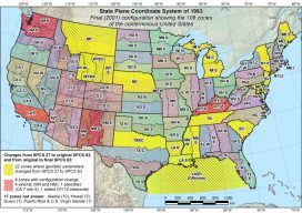
NGS Webinar on State Plane Coord. System Update
NGS’s free webinar on the State Plane Coordinate System Update has been rescheduled after the Federal government shutdown. It now will take place on March 7, 2:00 pm EST. Leading it will be Michael Dennis, PE, LS, National Geodetic Survey. NGS will establish the State Plane Coordinate System of 2022 (SPCS2022) as part of modernizing the National Spatial...
Where on Earth Is the Offset in ArcGIS Pro?
Life used to be nice and easy for us GIS guys. We used to roll out of bed, click start on our GIS software, go back to bed for an hour, and then think about making a nice simple 2D map. Then, all of a sudden everyone starts talking about 3D GIS and being able...
Advertisement