
Blog
Emily Tidey
Lecturer, Hydrographic Surveying, Otago University Dunedin, New Zealand We received a record number of nominations for geospatial professionals in New Zealand this year—and all were women! While difficult to choose from among the candidates, Emily Tidey stands out as an educator and specialist in the essential (but often overlooked) surveying discipline of hydrographic survey. Maritime...
Surveying Mentoring Program – Arizona
A new land surveying mentorship program is launching in Arizona. “Tell me and I forget, teach me and I may remember, involve me and I learn.” ― Benjamin Franklin The Launch In 2019, the United Surveyors of Arizona, a member-driven non-profit, is developing and facilitating the first ever officially sanctioned surveying mentorship program in Arizona....

Why I Heart My Geospatial Job
Above: Marc wears a poncho given to him by his students in Paraguay. xyHt celebrates Valentine’s Day by sharing the love our contributors feel about their geospatial careers. Marc Delgado Loves His Students’ Reactions I love to see and hear my students’ initial reactions when they draw their first map from memory. I’m now in...
Dale Atkinson
Director & Cadastral Surveyor, Atkinson & Booy Surveys Queensland, Australia The Surveying and Spatial Sciences Institute (SSSI) is a premier organization for promoting excellence in these fields, chiefly in Australia but with growing global recognition. At the 2017 Asia Pacific Spatial Excellence Awards in Queensland, few attendees were surprised that the Young Professional of the Year...
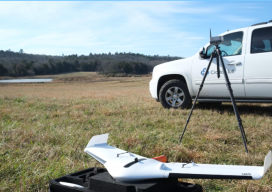
Sponsored: How Crafton Tull surveyed a 9,000 acres pipeline project in less than 45 days with a fixed-wing drone
Crafton Tull deploys Delair’s UX11 drone for oil and gas pipeline planning survey Facing a tight deadline, Crafton Tull turned to Delair’s UX11 drone to survey a 52-mile, 9,000-acre corridor for a new oil and gas pipeline—saving time, money, and producing a detailed survey that met its client’s requirements. Planning an oil and gas pipeline...

Sponsored: GreenValley International Releases Handheld Mobile LiBackpack C50 to Meet Demands for More Sophisticated and Affordable 3D Mapping Systems
GreenValley International, a 3D mapping hardware integrator and software developer for processing point cloud data, announced the release of its latest handheld mobile LiDAR scanner, the LiBackpack C50. The LiBackpack C50 features a 360° panoramic camera along with the LiDAR and SLAM integration mainstays and was developed in response to increasing demand across a variety...
Advertisement