
Blog
The Problem with QGIS and csv Files
Last month I was at the Maptime in Southampton (UK), helping QGIS new users with how to join tables and map EU referendum maps, when I came across an issue with something on QGIS I hadn’t spotted in the last *ahem* years of using it. When you drag and drop txt, csv, or other delimited...

xyHt News Links: 8/12/16
iSTAR 360 degree Measurement Module integrated by imaging companies Australia drifts away from GNSS measurements VGI in Land Administration: A Vision or a Necessity? A New Era in Land Administration Emerges The New State of Smart Cities: Analytics + 3D Visualization as a SaaS Esri and Leica partner to offer GIS/GPS grants to governments Strong...
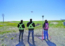
Collaboration in the Air and on the Ground: Skymatics, Ltd.
Two different firms–one UAS and one land surveying–partner to increase the values of both companies. xyHt’s Jeff Salmon interviewed the co-founders of the Alberta, Canadian firm Skymatics, Ltd.–EJ Burrows, CEO, and Dr. Cassidy Rankine, CTO–about their partnership with Element Land Surveys. xyHt: I understand Skymatics started in Bermuda in 2011 and has since expanded into...
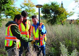
Dunwoody College of Technology
Surveying and Civil Engineering Technology Located on the edge of downtown Minneapolis, Minnesota, Dunwoody College of Technology’s surveying and civil engineering technology program offers a two-year Associate of Applied Science, which provides students a comprehensive, hands-on education that prepares them for successful surveying or civil engineering technician careers. The program has a dual focus on...
xyHt News Links: 8/5/16
Lead’Air Announces MIDAS Options with Ultimate Phase One Quality Trimble Acquires AXIO-NET GmbH – Recognized Provider of GNSS Services microdrones™ and DLRG Horneburg/Altes Land e.V. demonstrate promising new water rescue tactic using drones and compact flotation devices INTERGEO 2016: Augmented reality turns geo IT applications into a real experience ILMF Call for Papers – Deadline September...
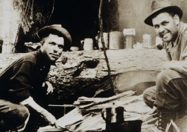
Geodesy around the Campfire
Although I thoroughly enjoy what I do for a living as a land surveyor specializing in geodetic control work, I often tell people it makes for really lousy dinner conversation. Rarely does it take more than a sentence or two to generate blank stares, gestures of confusion, and drastic attempts to change the subject. The...
Advertisement