Category Archives: Aerial/UAS

Aerial Data Collection: Little Drone Takes on Big Airport
In a first-of-its-kind project, a UAS is tasked to collect aerial data of an international airport. By Jeff Salmon Normally when you add the words “drone” and “airport” to a sentence, it classifies as cringe-inducing. Just the opposite is true with this ground-breaking UAS project. The Hartsfield-Jackson Atlanta International Airport in Atlanta, Georgia, usually abbreviated...
UAS: From FUD to FOMO
By Jeff Salmon Welcome to our semi-annual UAS-focused issue. Looking back over the last six years of UAS development, I am struck by how far the technology has progressed. Right before our eyes a new industry has developed, one that promises to bring far-reaching changes to our profession and indeed to the whole world. And...

15 Years of Growth at AXIS GeoSpatial
AXIS GeoSpatial provides more applications from one mapping effort. Easton, Maryland-based AXIS GeoSpatial LLC provides geospatial data and solutions to federal, state, and local government agencies and private sector firms, especially aerial mapping services. Heights talked with Erica Insley, marketing director for the firm. Heights: How did AXIS GeoSpatial get its start? Erica Insley: Founded in...
UAS Regulations Update
A look at recent and near-future legislation affecting UAVs for geospatial business use. By Jeff Salmon BVLOS Update The ability to fly beyond line of sight (BVLOS) is paramount to a wide range of UAS operations, including utility and pipeline inspections and monitoring, open pit mining, precision agriculture, corridor mapping, large-area mapping and surveying, and...
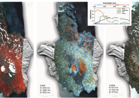
HSI on the Fly
One company details mapping applications of airborne hyperspectral imagery for agriculture, forestry, and resource mapping. By Patrick Burns and Scott Nowicki, PhD Remote sensing imagery has been collected with many different camera systems for many different applications over the past 50 years of the industry. Visible remote sensing imagery provides interpretable information available to most...
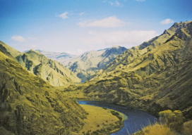
Re-imaging Hells Canyon
A geospatial company helps prepare for an environmental impact statement by scanning and orthorectifying historic imagery. Hells Canyon, North America’s deepest river gorge, encompasses a vast and remote region with dramatic changes in elevation, terrain, climate, and vegetation. Carved by the great Snake River, Hells Canyon plunges more than a mile below Oregon’s west rim...