Category Archives: Cartography
Atlas Obscura
Fall is a great time for travel: the weather’s cooled off, the youngsters are back in school (and not clogging up the national and state parks), and, as a bonus, there’s the fall foliage to enjoy. Back in the day (you know, before the advent of smartphones and digital maps), I used to rely on...
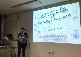
Mini Map-Makers
Cartographer “Captain Alice” teaches children to read and use maps as a communication tool. Alice Gadney believes her cartography business, Silver7 Mapping, is designed “to help people understand the world around them and their need for a great communications tool—the map.” And when she says “people,” she’s also including youngsters, starting with her five-year-old son,...

My First Trip to the Esri UC
No matter what flavor of GIS you roll, there is no ignoring the annual Esri user conference in San Diego. The highlight is the opening plenary session which is always given by the (co) founder of Esri, none other than Jack Dangermond. To discuss this fully, we have to start at the beginning, which was...
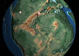
Find Your Home – on Pangaea
First, a bit of “geosplaining.” When we started this newsletter we looked for a name that had a “geo” feel without having geo in the name. For those who don’t follow geology, Pangaea was the most recent supercontinent which was formed roughly 200 to 250 million years ago, according to the plate tectonics theory. Flash...
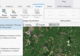
Using Ortho Imagery (Digital Aerial) in ArcGIS Pro
The new version of Esri’s ArcGIS Pro software offers the capability to use stereo imagery, something of great use to those looking to digitize and use 3D vector data. To this end, I thought I would try bringing in some stereo aerial data to see how the process works within ArcGIS Pro. Vague Knowledge At...

Alison DeGraff Ollivierre
Cartographer, National Geographic Maps Colorado, USA With interests in participatory mapping, outdoor recreation and travel cartography, small-island developing states, climate change, spatial planning, and conservation, Aly Ollivierre spreads her work as a cartographer widely and generously. She’s a cartographer at National Geographic Maps, a freelancer doing cartography/GIS work at Tombolo Maps & Design, and a...