Core Articles

New Digital World Needs Data
Next-generation surveyors require specialized education and training to fill the role of geospatial data specialists. Many emerging geospatial applications, such as digital twins, 3D modeling, monitoring, virtual reality, and autonomous vehicles, are based on big digital datasets. Building a 3D digital world starts with accurate data that ties to a point on the ground, so...

Refining Measurement
A land surveyor unpacks the concept of accuracy “Accuracy is addictive,” my friend David Doyle once said. Doyle is a geodesist by trade. For someone in his line of work, this addiction has a rich tradition. Geodesy is the study of Earth’s shape, rotation, and gravity field. The discipline involves an eternal quest to refine...
Meet the Future of Mapping and Surveying at XPONENTIAL 2022
Innovation has never existed in a vacuum. Our world’s greatest technological advances are remembered not just for their scientific significance, but for the way they transformed the fabric of society itself. That’s why it’s critical that global leaders in uncrewed and autonomous technology collaborate on cutting-edge innovations that safely, securely, and reliably improve the human...
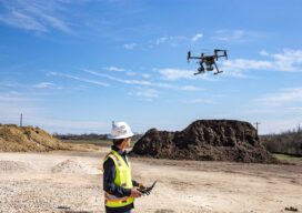
Drones in Construction
For decades the construction industry didn’t change much-and then UAV technologies came along Unmanned aerial vehicles (UAVs) or drones, as they are commonly called, are mostly electric-powered aircraft, which do not require a pilot onboard and are used to perform tasks that are either too dangerous for humans to do or too expensive with other...
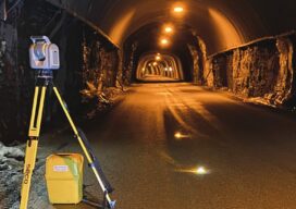
Tunnelling to a New Approach
A surveyor switches from conventional technology to the Trimble SX12, enabling her to match the frenetic pace at six times the speed of multiple-person crews.
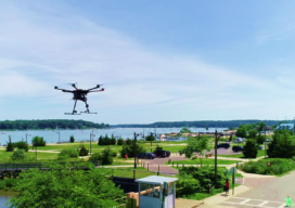
Walden Environmental Engineering Captures New Insights and Revenue
Emesent Hovermap was used by Harkin Aerial to conduct internal and external scans of assets for Walden Environmental Engineering. This resulted in simplified and streamlined projects with improved efficiency.