Category Archives: GNSS/Location Tech

The Rise of Value-packed RTK
Barriers are being removed for adaptable and inexpensive, high-precision GNSS. Many of you may be familiar with traditional base-rover applications for RTK such as surveying and mapping—with precision that typically comes with a large price tag. However, Swift Navigation provides a multi-frequency, multi-constellation, fully RTK-capable GNSS receiver called the Piksi Multi with a smaller price...

Got GPS? Thank Hedy Lamarr
I know what you’re thinking, and you’re right. Hedy Lamarr, the gorgeous and glamorous Hollywood star of the ‘30s and ‘40s, had nothing to do with the invention of GPS. She did, however, invent a technology that underpins almost all modern communications. Lamarr and avant-garde composer George Antheil invented and patented a technology that Bluetooth,...
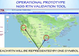
How Accurate Is an RTN?
Many surveyors have realized the benefits of using real-time GNSS networks (RTN) for survey-grade positioning. Saving time, equipment, and personnel means saving project costs. The thing about real-time GNSS surveying, however, is that “rover expertise” needs to be applied in the field (not the office). Additionally, many factors involved with GNSS signalization, as well as...
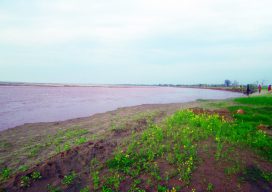
The Data of River Dynamics
Using GIS tools and readily accessible satellite data to study rapid change in rivers. Editor’s note: The dynamics of rivers can range from relatively stable to rapidly shifting, the latter especially in flood-prone regions exacerbated by a global increase in extreme weather events. The impacts are environmental, but also economic, social, and cadastral. Surveyors, for...

CORS Map
A First for Africa Geospatial professionals don’t need an introduction to CORS. For everyone else, it’s an acronym that stands for continuously operating reference systems: geodetic receivers that log GNSS observables continuously which, when transmitted to users with survey-grade receivers, help them achieve centimeter-accuracy measurements. CORS stations have a range of about 70 kilometers (~43...

Precisely Shot
Aerial imaging, GIS, and GNSS play a crucial role in the success of golf’s 2018 U.S. Open Championship. “Basically, we need to construct a small city—every year and in a different location,” said Timothy Lloyd, senior manager of U.S. Open operations at the United States Golf Association (USGA). Lloyd’s team is charged with planning and...