Category Archives: Lidar/Imaging
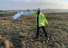
A Decade of Uncrewed Photogrammetry
Some might have had a peek at photogrammetry drones before 2013, but for me 2023 marks a decade since I first laid eyes on an uncrewed aircraft that “claimed” to do what I had been doing for years in bigger, more stable airplanes in the joyful company of pilots, copilots, camera operators, and navigators. In...
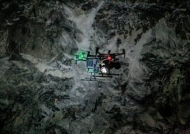
Autonomous Drone Mapping
How interior spaces like mines are being scanned and imaged by a drone that works without a pilot or connectivity. There is a scene in the Ridley Scott-directed 2012 sci-fi thriller “Prometheus” where a deep space exploration crew lands on a planet and discovers an underground labyrinth. They lob a levitating orb down a tunnel,...
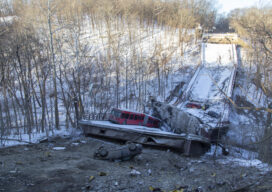
Rapidly Mapping Infrastructure
Could a Pittsburgh-based start-up help improve (and save) America’s bridges? Early in the morning of January 28, 2022, a Pittsburgh Regional Transit Authority bus crossing the Fern Hollow Bridge began bouncing and shaking for no apparent reason. Moments later it plummeted into a ravine along with several other vehicles as the bridge collapsed beneath them....

The Future of Aerial Photogrammetry
Rapid advances in technology are changing the way we map from the air, but the 100-year-old technology of mapping by crewed airplanes will continue to fly into the future For thousands of years cartographers made maps using tools that mostly measured angles and distances, allowing for positioning of fixed objects over unknown topography. The earliest...

xyHt Magazine Heights 2023
Click on the cover to view the Heights 2023 supplement to xyHt magazine. Articles in the issue include: From Nadir to Oblique: From traditional airplanes to new-fangled gyroplanes, we take a look at several aspects of the aerial geospatial technologies that just keep getting better. The Future of Photogrammetry: While UAVs continue to emerge as aerial mapping vehicles, there...
Sponsored Content: Revolutionizing Utility Mapping in North America
As many of you already know, inaccurate utility locational data is one of the main causes of utility strikes. In 2021, this has led to an estimated $30 billion societal cost due to delays and damages in the USA alone, according to The 2021 Damage Information Reporting Tool (DIRT) Report released in October by the...