Category Archives: Lidar/Imaging
Lidar Uncovers Massive Ancient City in Amazon
hanks to aerial lidar surveying, a huge ancient city has been uncovered in the Amazon, unseen for thousands of years due to lush vegetation.

With friends like these, who needs consumer reviews?
By Matt Kowalski Likely, everyone can agree that we prefer to make informed decisions when spending our hard-earned money. If it is a car, computer, or the pen that I used to write this you can find a consumer report about it. Don’t believe me? Search “pen consumer report.” You will not only find Consumer...

Preserving the World’s Cultural Heritage
Scanning the ruins of a castle in Romania will help preserve the country’s past and the literary myth of Dracula

BIM, a Basilica, and a Balloon
An award-winning digital twin project is interesting on many levels, and not just because it features one of the world’s most famous landmarks. Shown above: The AI-driven camera-based solution Italferr developed to capture the upper dome and galleries. Source: Italferr Davide Porzio, CDE manager, BIM coordinator, Italferr S.P.A. speaks enthusiastically about building a digital twin...

GoGeomatics Expo Puts Canada on the Geospatial Map
In the words of Will Cadell, “Geospatial is changing everything.” That was not only one of the opening lines of a visionary talk by Cadell, founder and CEO of geospatial consultancy Sparkgeo, it seemed to capture the sentiment of exhibitors, speakers and attendees at GoGeomatics’ inaugural conference. Held in Calgary, Alberta from Nov. 6 –...
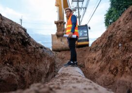
Out of Sight; Not Out of Mind
Cities are now creating their own subsurface utility maps to manage their underground assets. But the lack of an open-based geospatial model means that data are often not interoperable. A new mapping standard aims to fix that. In the years since 2004 when a leaking gas pipeline exploded in Ghislenghien, an industrial town in Belgium,...