Category Archives: Lidar/Imaging
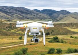
Safety is Paramount in Aerial Drone Mapping
As the Federal Aviation Administration (FAA) prepares to release its ruling covering uncrewed aircraft flights beyond visual line of sight (BVLOS) in the National Airspace (NAS) the entire industry is holding its breath preparing for a new era of certainty and expansion. Aerial photogrammetry will be one of the immediate beneficiaries of this new policy...

Built for Danger
While the operator stays safe, indoor drones carrying lidar and SLAM technology create a 3D map of the inside of hazardous spaces Nuclear power plants, ballast tanks, underground mines, toxic chemical plants, sewers, offshore oil storage, decommissioned industrial facilities—none of these are places suitable for humans; yet monitoring and inspection of the interiors are often...
Disruptive Lidar Tech
Technologies developed for autonomy and consumer applications are opening up new user segments and rewriting conventional workflows A construction inspector sweeps their phone over an open trench creating a 3D as-built of the utilities within. This is just one example of low-cost, rapid, simplified reality capture is challenging conventional wisdom on how reality capture should...

Seth Gulich
23 Young Geospatial Professionals to Watch in 2023 – 20 of 23 Name: Seth GulichCompany: Bowman Current position: UAS Program ManagerAge: 28 Education: BS in Surveying Engineering, Penn State University Gulich is a young professional with more than eight years of surveying and geospatial experience in the AEC industry. He is a licensed professional surveyor and...
Adailin Lebron Bengochea
23 Young Geospatial Professionals to Watch in 2023 – 14 of 23 Name: Adailin Lebron BengocheaCompany: City of Grapevine, TexasCurrent position: GIS Engineering SpecialistAge: 33 Education: MA Geo in GIS, Texas State University; BS in Geography and Anthropology, The University of Texas at Austin Although Bengochea has always enjoyed a good map and navigating atlases...

Ready, Re-set, Go
Post-pandemic digital transformation was on everyone’s mind at INTERGEO. With its mojo back, the world’s biggest geospatial trade event can once again offer the best geo-business innovations to get you all set for 2023. Germany’s annual INTERGEO event is the CES of the geospatial industry. If its Las Vegas counterpart is high on consumer electronics,...