Category Archives: Lidar/Imaging

GEO Business 2017
Nicholas makes the annual pilgrimage to GEO Business for xyHt This blog is going to start with a short piece about skips. If you are afraid of skips (skips are what you’d call “dumpsters” across the Atlantic), turn away now …. Monday morning and 24 hrs from the start of GEO Business 2017, I get...
GeoDude: The Adoption Status of Laser Scanning Today, Part 1
By Geoffrey Jacobs Note from the editor in chief: In 2006 when I began at this magazine’s predecessor, Professional Surveyor, Geoff Jacobs was already an established 3D scanning columnist, trusted as an industry specialist and read regularly by our subscribers. He’s a significant leader in the field; Geoff is also a pleasure to work with....

HyperStacking GPR
A new technology shows promise for enabling users to see deeper targets and operate in noisy conditions. By Jeffrey Feigin, PhD Editor’s Note: The field of ground-penetrating radar (GPR) is experiencing a new wave of development. For many of our readers, first impressions of legacy GPR gear included a lot of limitations and confusing images....

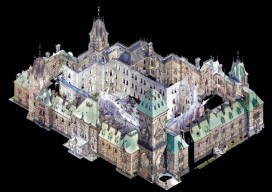
Leveraging Point Clouds
Above: This image illustrates the transition from point clouds to modeled deliverables. These non-BIM solids were later used for com-putational fluid dynamics analysis to ensure proper airflow throughout the room. Three ways you can derive value from point clouds past the pre-design phase. By Daniel Chapek Reality capture is a powerful way to digitize the...
Three Trends at SPAR International 2017
I’ve attended SPAR every year since its inception in 2004, always while working for a vendor for 3D laser scanning products. This year, sporting my new xyHt shirt, I viewed the event from a different perspective. Let me preface this “review” by noting that I did not do a complete walk-around of each vendor’s booth;...

15 Years of Growth at AXIS GeoSpatial
AXIS GeoSpatial provides more applications from one mapping effort. Easton, Maryland-based AXIS GeoSpatial LLC provides geospatial data and solutions to federal, state, and local government agencies and private sector firms, especially aerial mapping services. Heights talked with Erica Insley, marketing director for the firm. Heights: How did AXIS GeoSpatial get its start? Erica Insley: Founded in...