Category Archives: Lidar/Imaging

Creating Energy From Images
Geospatial information has long played an essential role in the energy industry, but now a new technology is cutting costs while improving the flow of knowledge. Editor’s note: The energy sector, oil and gas in particular, has grown more rapidly in the past half dozen years than in the past half a century. New fields,...
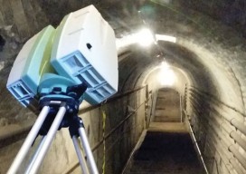
Tunnel Vision
Dis-located What do you think of all this new technology? Do you love it? Do you fear it? Does it keep advancing faster than you can keep up? In our industries, new technology usually means change. We will probably need to learn something new to make this new thing work. That’s a good thing, right? ...
Easy Park Datasets
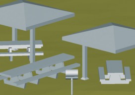
Above: Isometric view of 3D model of centralized benches, barbeques, and gazebos at Prescott National Forest. Collecting lidar data for as-built plans opt a busy national forest recreation site The Prescott National Forest (PNF) is a 1.25-million acre United States National Forest located in north central Arizona, with more than 20 developed recreation sites and an...
Time to Do More
xyHt has been watching a recent flurry of news releases and webinar announcements from Trimble tagged with the slogan “Time to Do More.” There were quite a few major new products and enhancements announced so we wondered: Was this simply a marketing campaign? Or was this some new direction for Trimble? We decided to ask...

Go Wide
While you were waiting for your legacy plotter to respond, wide-format output technology quietly evolved to provide substantial productivity gains and superior quality. When you consider the state of legacy plotters and printers, think about all the time, not to mention frustration, you’ve spent waiting for files to upload to plotters, lengthy plot cycles (especially for...

Surrogate UAS
Above: Hart Drobish, president of Courtney Aviation, was a contractor to the forest service flying the air tactical control platforms on the Happy Camp Complex wildfire. Additionally, Drobish served as a ground liaison contact on the project, managing the flow of infrared and visual imagery from the aircraft to the end users. Combining UAV technology...