Category Archives: Lidar/Imaging
Sravan Puttagunta
Sravan Puttagunta – CEO, Civil Maps – California, USA Think big geospatial data—very big geospatial data. When people dream up digital worlds of interactive 3D, virtual reality, and augmented reality, they often overlook the next step: dealing with massive amounts of data. Civil Maps, a relatively young company, has decided to slay some big data...
Perri Howard
Perri Howard – Geospatially inspired artist – Washington USA Perri Howard, a Seattle-based artist, sculptor, pilot, and mariner, came to the attention of the surveying community through several of her public and studio art projects that weave in spatial themes. One of these was the photo and sound series “Precisely Known Completely Lost,” with close-up...
Lindsay Renkel
Lindsay Renkel – Geospatial Marketing Specialist, Trimble – Colorado USA In the not-so-recent past, segments of geospatial industries were viewed more as rigid verticals, and cross-discipline and integrated workflows were realized through innovation in applied tech. That’s when companies like Trimble began to organize under new functional divisions. Marketing a broader range of products and services could...
Johannes Riegl Jr.
Johannes Riegl Jr. – Chief Marketing Officer, Riegl Measurement Systems – Austria The expectations would be quite high: the name, Riegl, is among the most celebrated lineages of measurement systems in the world—terrestrial, mobile, and airborne lidar. Could a young fellow in such a critical role grow the business and raise the profile to do...
123D Catch for the Masses
How to Make A 3D Model of Your Sleeping Cat Stereoscopic imaging, better known as 3D, is not new. In the 16th century, “binocular” images were viewed cross-eyed. In 1838, Sir Charles Wheatstone invented the stereoscope to give depth to images. It presented two offset 2D images separately to the left and right eye of...
Wizardly 3D
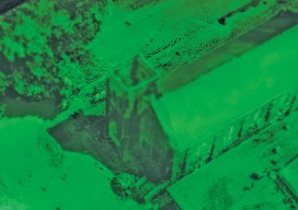
Above: This hologram of a church in Texas was built from a combination of airborne and terrestrial lidar scans. More than just illusions, hologram technology is booming. Every once in a while a new product or technology comes out that makes you do a double take and think, “Wait, what is that?” This happened to me...