Category Archives: Surveying
The Center for the Arts in Nevada County, California Optimizes Operations
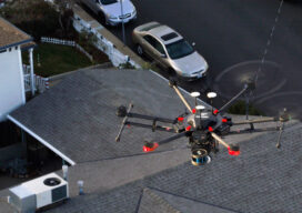
Mobile LiDAR scanner Hovermap was used to conduct an internal and external scan of the facility in just over an hour to capture accurate as-builts and CAD drawings.
A Hard Day’s Work
I’m sure some surveyors love doing construction stakeout. Even with the advent of GPS machine control and the associated modeling that goes with that type of work, there are still a lot of stakes being driven into the ground. I am one who would be happy to never pound another stake. Some states require these...
Teaching the Future
A small university on Michigan’s Upper Peninsula is educating the next generation of surveyors and geospatial engineers

xyHt Weekly News Recap: 07/16/2021
Esri Releases New Predictive 2050 Global Land Cover Map Esri Awards GIS Users for Innovations Velodyne Lidar Partners with NVIDIA Metropolis for Infrastructure Solutions Zoom75 & Zoom 95 – The New GeoMax Robotic Total Stations Lidar Helps Reveal Radiation Hot Spots at Chernobyl GIS-Pro 2021: October 3-6, 2021 Setting the Record Straight: The RETAIN Act...

The Pressure Cooker – Interviews
Other than public speaking, perhaps the most anxiety-filled experience of life is the process of taking a job interview. The anxiety starts building from the moment you have been notified of the date and time. It borders on torture, sometimes for a week or more. It is often said that the best time to look...
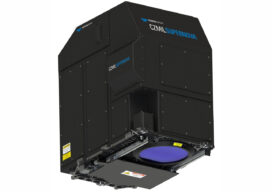
CZMIL SuperNova is Changing Bathymetric Lidar
CZMIL SuperNova, Teledyne Optech’s next generation bathymetric lidar system, is changing the way information about coastal territory is collected and processed. Terratec AS, a leading Norwegian mapping firm, is the first private company to acquire the CZMIL SuperNova and the only company in the EU to engage in work around environmental change and coastal zone mapping...