Category Archives: Surveying

Just Say No
This article appeared in xyHt‘s e-newsletter, Field Notes. We email it once a month, and it covers a variety of land surveying topics in a conversational tone. You’re welcome to subscribe to the e-newsletter here. (You’ll also receive the Pangaea newsletter with your subscription.) As I have aged and learned, I have worked diligently to improve myself, whether through...
The Early Days of 3D Scanning
When I first came across Cyra Technologies Inc., a start-up that was developing 3D laser scanning, I was working at Trimble Navigation in Sunnyvale, California, in the heart of the San Francisco Bay area’s “Silicon Valley.” I consider myself lucky. I had the good fortune to be deeply involved in the very beginning of 3D...

Scans, Soundings, Surve and Sailcargo: Building Ceiba with Surveying
Timeless maritime arts and craftwork mixed with modern technologies—including high-precision surveying—are helping reintroduce wind power to seaborne trade in Ceiba. It was a chance meeting that changed two lives. It may also change the way the world thinks about maritime shipping. It’s Ceiba! An accomplished sailor, Danielle Doggett loves tall ships—the large wind-powered sailing vessels...

BIM It Up and Fly Them In, Mactan-Cebu Airport!
Designed using building information modeling, Mactan-Cebu International Airport is a tribute not only to technology but also team collaboration and creativity. Featured image: Photomontage (by Marcel Lam) shows the BIM model combined with an actual photo of the Mactan-Cebu International Airport’s roof. Everything about the design of the newly built Terminal 2 at the Mactan-Cebu...
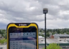
Android Field Software on a Nifty Tablet
A quick test drive of the new Access 2020 survey field software on a companion small tablet revealed some coolness. The advent of survey software for Android, long in the works, has brought welcome new options for mobile field platforms. Over the years I’ve used a lot of different field controllers, and more recently tried...

New Heights: Aerial Photography, Aerial Data
A Louisiana company upgrades its aerial photography camera hoping its business will soar Featured image: Looking up into the belly of a Cessna 206 airplane. The camera is looking down through the hole. Infrastructure like bridges (this one in Tampa, Florida), airports and oil and gas pipelines require regular aerial mapping for maintenance, installation and...