Category Archives: Surveying

Another Curveball: Coronavirus and Geospatial
Out of the blue, we’re facing another curveball. The current global concern (COVID-19, aka the Coronavirus) was generally not anticipated, and the situation changes daily. It was hoped that, by the time this is published, the situation would have calmed dramatically—but sadly it has taken a turn for the worse. Thus far disruptions have only...

Use This Down Time to Become a Better Surveyor
Coming Out Smarter, Stronger, and More Valuable After the Surveying Slowdown is Over Unprecedented times have the world economy racing toward a potential recession and possibly taking the land surveying profession with it. In many parts of the United States surveying is at a near standstill with the shutdown of non-essential businesses due to the...

In the Face of COVID-19: Keep Calm and Survey On
Coping with COVID-19 requires flexibility and planning. Don’t worry, this is not yet another article on how to wash your hands, stay home if you’re sick, and sneeze into a tissue or your elbow. I’m assuming you’re aware of the basics. Instead I focus on ideas for coping with COVID-19 should your geospatial business become...
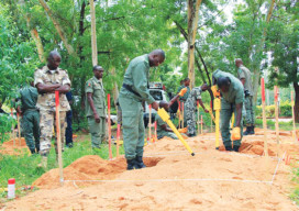
Locating More than Monuments: Demining with Schonstedt
How the Schonstedt Humanitarian Demining Initiative works—and how you can help. You know the magnetic locator well, no doubt. Whether yours is a Schonstedt or another brand, geospatial professionals are familiar with these instruments due to their common use in detecting survey markers. Border-marking studs, often sunk by surveyors gone by, are made of the...
3D Site: Road Construction amid Frustrated Residents
In a residential subdivision in Saskatchewan, a 3D site plan appeases frustrated residents as well as a tight construction deadline. Many homeowners are attracted to the yin and yang lifestyle of having a cozy country home with easy access to the excitement of a vibrant city. A Canadian residential subdivision in Saskatchewan seems to capture...

3D Network Adjustments in Surveying with Rigorous Least Squares Adjustments
Performing least squares adjustments in a 3D world can challenge our control networks. Geomatic professionals need the tools to deliver more rigorous least squares adjustments in 3D network adjustments.