A quick test drive of the new Access 2020 survey field software on a companion small tablet revealed some coolness.
The advent of survey software for Android, long in the works, has brought welcome new options for mobile field platforms. Over the years I’ve used a lot of different field controllers, and more recently tried field software on Windows 10 tablets. Several popular survey packages have released Android versions, and overall, these have made the transition quite successfully—the same functionality of the legacy mobile platform versions, while taking advantage of the growing options for mobile devices.
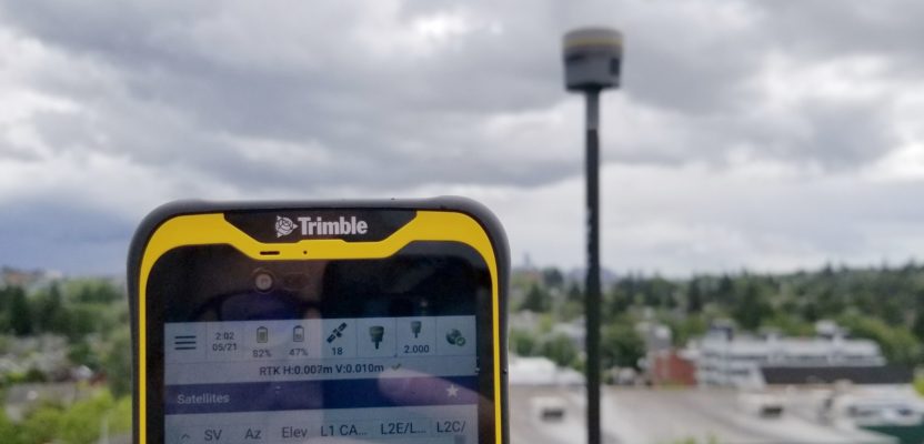
Trimble has released Access 2020, for Windows 10 devices, like the Trimble TSC7, which was a merger of a familiar style of data controller, but with more screen to work with, and for tablets like the T10. Also recently released is Access 2020 for Android, that runs on the smaller TDC600 tablet. The Windows version will run on nearly any Win 10 device, but at this time, the Android version runs only on the TDC600.
I’d had the opportunity to use past versions of Access (and its predecessor Survey Controller) in the field extensively, mostly on an old TSC2—which operated on a Windows Mobile platform, an OS many of us are not sad to see headed for its sunset. We are all getting spoiled by the ease of use of more modern mobile platforms and devices, like our consumer devices, and will not miss the mess of cables and cumbersome data transfer paths of the old gear and OS. Many users have grown to wish our field controllers were as simple and versatile as those powerful little mobile devices we all carry in our pockets.
There is nothing like the form factor of sturdy traditional data controllers, especially the tactile keyboards. But I am probably not alone in seeking something smaller, lighter, and simpler, for various situations. The idea of a light data device, paired with a GNSS rover, holds appeal for quick ad hoc jobs, stakeout, control work, etc. Until someone invents a levitating rover, we are stuck with lugging a pole, but reducing the rest of the kit to two lightweight items is quite appealing.
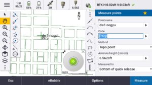
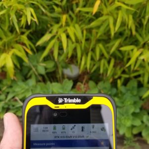
Using the split screen mode, with the e-bubble and new “snap-to” menu displayed.
TDC600 Basics
This new tablet runs Android 8.0, with a six-inch screen, like the extra screen real estate of TSC7, but more compact—essentially the size and feel of a large phone, or phablet. In test driving it, I found myself putting it in my back pocket like my phone. It has a large user-swappable battery and is more ruggedized than your average phone.
I added many of the same apps that I have on my phone: GNSS Status, Gmail, Dropbox, etc. I did not add a SIM but if I did, I could use it as a 4G LTE phone. I connected to WiFi via the same mobile hotspot I use in the field for surveying. It has a powerful processor, 4GB memory and 64GB internal storage. It has forward and rear-facing cameras, and charges with a standard C-type USB—a standard tablet but ruggedized.
My only misgiving is that the on-screen keyboard, when running in portrait mode, is down low on the screen, putting the space bar frustratingly close to the “home” button. All too often my fat finger would hit “home” and I had to toggle back to Access. I had not yet tried disabling the home button, but if I could recommend one feature enhancement, could there be an option to temporarily disable it when Access is open?
Access 2020
Being familiar with older versions of Access, I set out to test drive without having to crack open a manual, and simply went about some regular field work. There was not a real learning curve for the software, just some getting used to for the tablet. I looked for new features, noting several that folks had been asking for. The familiar menu structures are all there and I was happy to see a few new ones. There is now a snap-to menu, being able to snap to ends, centers and intersections of imported geometries, like DXF files of plans, XML, and IFC models (BIM). This minimizes the need to calc, or import points created in advance. With the Sync manager it was easy to get thing in and out of Trimble Business Center (TBC).
Other coolness includes the split screen option. You can do this in portrait mode by dragging up a second window from the bottom, or when you rotate the TDC600 to landscape. Split screen is one reason why I like more screen real estate than the legacy data controllers. The TDC has about the same size screen as the TSC7 (that is always in landscape mode). I like being able to have the map on one side, and the measure, staking, status, or other window on the other side-along with the e-bubble.
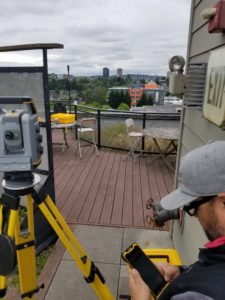
Connected to an S7 total station. All of the same functionality as the Win versions of Trimble Access was there, but at this time Roads is the only additional module, but more are in the works. To run robotic with the TDC600, and additional radio is needed.
I was in the midst of doing some testing of the multi-constellation GNSS capabilities of a number of rovers, and when it came to the Trimble units, it was prime opportunity to try out Access 2020 on the TDC600. I had set out an array of test points on the roof of our condo (yes, the home office paradigm of late), and did days of static observations to post-process against local CORS. I set points in different multipath environments and under the canopy of the roof garden.
To establish tight inverses between the marks so I could check GNSS results, I invited Thomas Roberts of Frontier Precision (a Trimble distributor in the western states) to bring a robotic total station and used Access 2020/TDC600 to shoot the marks. The new system connected just fine via Bluetooth with his Trimble S7. We did not run robotic; the Bluetooth won’t reach that far. To run the robot from the rod there is an auxiliary 2.4GHz radio (TDL2.4) that pairs with the TDC600.
All of the standard TS functions were there, but it appears that Roads is the only additional package on this version but have been assured others will soon follow. It supports the S-series TS, but not the Trimble SX10 (yet). The shots on my test marks went smoothly, and then we had some fun with the GNSS rovers, checking against my post-processed control and inverse between.
A GNSS Bonus
A new GNSS feature in Access 2020 (and not just the Android version) is that you can choose different satellite configurations on repeat observations to ensure confidence. This works best on a full multi-constellation supported rover, and if the base or network is broadcasting multi-constellations. For instance, you can ask Access to choose multiple satellite geometries; all; set-A; and set-B. It chooses subsets of the sats in view to provide alternate, optimal geometry as different from the other as can be had with the available satellites in view. But why? This is to address the old dilemma (and burden) of having to wait an hour or more, or revisit a site, to get confidence in the first.
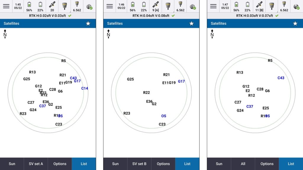
A new feature is a way to choose different sat configurations, a way to verify your work under different sat geometries to minimize the need to do the traditional long time splits between sessions. Full (left), Set A (center), and Set B (right).
One of the oldest best practices for GPS, and later GNSS, is to do multiple session with different sat geometries. In the days of GPS only, when there fewer sats, it might be a different time on a different, day or days. Once Glonass was added (and when it reached a level of reliability) there were more satellites in view, and (through independent testing) many users concluded that you could reduce the “session splits” to as little as an hour; so waiting a day or more was not necessary. I remember experimenting with manually turning on and off sats to force different geometries, much in the manner of this new function. But until Galileo (GAL) was added to rovers, as with Beidou (BDS), there were often too few satellites to work with for such manual tricks to be effective. But now there is.
Digressing a bit from the Access 2020/TDC600 test drive, the following GNSS testing with the same, turned out to be pretty interesting. Connecting first to an old R8, GNSS operations with Access 2020/TDC600 and NTRIP corrections from a local base worked just fine. But with only GPS and Glonass (GLN) supported, good shots on the multipath hazard and canopy marks were limited. And attempts to use the new alternate geometries function often lacked enough sats.
Switching to a R10, and connecting to RTCM3.2-MSM ) from the same base, GPS+GLN+GAL yielded good shots on all marks, and the alternate geometry function worked. But then we fired up an R10-2 (essentially a Trimble R12) and it was like someone pumped nitro into the engine.
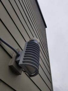
A fun exercise in checking performance of the rover in a high multipath environment. I stuck the rover head up on a light fixture and wiggled it around to get it level (thanks e-bubble). There was little loss of precision; lots of sats blocked, and others rejected, but with so many satellites up there now, it worked.
A side note about correction formats, as there is often confusion over that: to do multi-constellation RTK, the base or network needs to broadcast multi-constellation corrections. For instance, if your based or network does GPS-only, or GPS+GLN, then the old correction formats of RTCM, like RTCM2.3, RTCM3.1 or something like CMR+ works. To add Galileo and Beidou, you need to use the newer RTCM: RTCM3.2-MSM (the MSM stands for “multiple signal message”). Or you can use something like CMRx. As most (if not all) RTN that have implemented the new constellations are broadcasting at least RTCM3.2-MSM, that works just fine, And I have not found any advantages of using anything else for general surveying and mapping (but there may be special needs where a different format might be optimal…check with your equipment dealer). GPS+GLN+GAL+BDS adds up to a lot of satellites…most cool.
The evolution of the R10 to the R12 is still a point of confusion in the surveying community; I too, was confused, so I recently got a Trimble engineer to explain. In short, the R10-2 was an upgrade with more powerful processors than the original R10. This was to speed operations but also to accommodate a new generation of RTK engine, one that could do the complex mixing and matching of sats on the multiple constellations, and of the multiple new signals each are broadcasting. The R12 has the new processors and RTK engine (Trimble calls it ProPoint), and the R10-2’s can have the new engine updated via a firmware upgrade. With the GAL and BDS constellations reaching their nominal full compliments in 2020, the time was right. Even two years ago, much of the multi-constellation magic was not quite here.
Then I put the rover head under a shrub for grins. While some sats were lost, the precision held up reasonably well.
For instance, in an open sky shot, I was seeing between 30- and 38 sats with the R10-2 (updated) and it would pick about 26-to 28 of those, with an average of about an 18-to 19 mix in solution during measurements when getting corrections form the base/network—using combinations of GPS+GLN+GAL+BDS. Note that it needs at least two of any constellation to add to the mix. Typical predicted precisions were 0.02’ (H) and 0.03’(V) in the open, ranging from 0.05’-0.07’(H) and 0.06 ‘-0.10’(V) up against a wall or under canopy. Inverses nailed it to the hundredth. Of course, no two locations are alike, but the speed at which it acquires and resolves solutions is pretty impressive—a real contrast between successive models. There are a lot of fine rovers out there, and many have new generation RTK engines well designed for multi-constellation operations—this test drive is not an endorsement of any particular gear—just an example of the new coolness available.
Using the alternate geometries tool, it would go from, 18- to 19 sats when choosing “all,” to between six and 11 for either “set A” and set B”. Precision dropped slightly for the alternate geometries, but quite sufficient (IMHO) to serve as an alternative to a return site visit or a long-session split. This warrants further testing of course.
Another test, done as an afterthought, was not related to the TDC600 or Access 2020 per se, but as I had a full constellation rover running, I just had to try the following scenario. What if some telecommunication company got permission to put RF transmissions right int the same L-Band as GPS? Potentially interfering with GPS—who would ever consider letting that happen? Anyhow, say it happens and there is a tower in your vicinity and some of this “sanctioned interference” makes GPS unusable (and possibly some of Glonass)? So I turned off GPS and fixed without it. Then I also turned off Glonass and fixed without both With Galileo and Beidou it performed good enough, but not as well as with all four constellations. Nice to know there are now multiple options.
Each New Step
I kind of got off on a tangent there (sorry: GNSS geek), but the test drive of the new Android version and the nifty little tablet showed me more functionality and versatility than I originally envisioned.
It is all too tempting to look back and think about the days when our old GPS-only-brick-rovers, an old Win CE data controller, and a tangle of antenna and serial cables hooked up to batteries and a modem in a backpack was just fine for RTK. And in clear sky we could hit values to hundredths. The challenges of those days certainly put a premium on good field practices. And while the same care must be taught, new gear does not just offer the ability to do more work, faster and cheaper, but also comes with new QA/QC tools.
We night have done just fine back in the day, but now we can work in more places, take less time to verify and gain confidence in our survey observations, and work with simpler, lighter, yet more versatile tools. Cool just keeps getting cooler across the board.