
They’re guided by people and powered by geospatial information.
We’ve all heard the buzzword, “smart city.” But what is a smart city, and what makes it smarter than others?
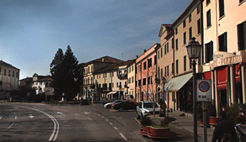
The city of Padua used geospatial solutions to develop a precise inventory of its streetlight system to increase energy efficiency and cut pollution. The city of Padua used geospatial solutions to develop a precise inventory of its streetlight system to increase energy efficiency and cut pollution.
One of the key characteristics is the ability to make effective connections—among citizens, assets, and services—by using technology to support and improve the interaction among people and government. In doing so, a city enhances its citizens’ well being as well as its overall performance and efficiency.
Most cities are not concerned about being labeled as “smart.” Instead, they focus on being effective in providing a safe, pleasant, and sustainable environment for their citizens, visitors, and businesses. But to do that, many are already taking the first steps to leverage technology to benefit their communities.
Smart cities use information and technology to support a diverse array of physical and non-physical activities. Roads and buildings, infrastructure, and public safety utilize a variety of technologies to increase productivity and quality. Similarly, non-physical functions such as permitting, planning, and administration also use technology to streamline processes and manage costs.
City leaders can draw information from multiple sources in the physical and administrative worlds. This information, combined with tools for analysis and feedback, enable them to make better decisions and optimize the use of physical, human, and monetary resources.
 A smart city thrives through the effective use of ideas and technologies. It all begins with information on the city’s assets and resources.
Smart Foundation
Much of a city’s service is related to the physical world—structures and facilities for housing and business, utilities, transportation, education, and recreation. The work to understand and manage its assets occupies a significant portion of a city’s time and budget. By making these processes more efficient and tying them to other services and activities, a city becomes smarter and more effective.
Effective city management begins with knowing the location and condition of its physical assets. Geospatial solutions enable cities to collect and manage authoritative data to assess and understand their built and natural environment. The data is then transformed into actionable information that forms the basis for productive actions and workflows.
The information processes of smart cities can be broken into three main areas: gathering and managing data; processing and analysis; and putting information to work in efficient, collaborative ways.
Collecting Big Data
With large geographic areas containing buildings, utilities, and infrastructure, cities face a significant challenge in capturing data with sufficient detail. The sheer volume of data needed for effective management can be daunting. Geospatial solutions to collect and manage data enable cities to build and operate flexible, accurate databases for built and natural features. Information can be gathered using blended technologies for imaging, positioning, and specialized information-management for use in prioritizing planning and response efforts.
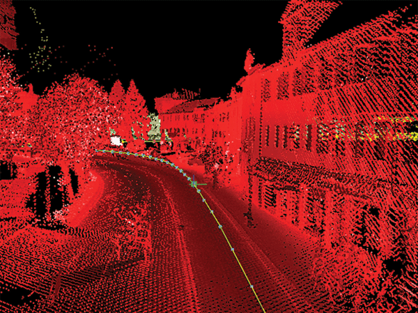
For example, local governments in Italy’s Padua region began work to modernize the existing system of streetlights under a sustainable energy action plan designed to increase efficiency, battle climate change, and reduce light pollution. First, they needed to create an inventory of the area’s system of streetlights. Using a solution produced by Trimble of vehicle-mounted sensors, handheld devices, and analytical software, contractors cut in half the number of field technicians needed for the project and reduced the time required for data collection by 20%.
In a three-month period, the team captured data on more than 7,400 individual fixtures. As part of normal operation, the geospatial systems collected additional information on the streets and structures. In addition to faster and more precise data collection, the solution provided increased safety for the field technicians and reduced disruption to traffic and commerce.
The streetlight inventory, which was delivered through GIS and engineering design systems, will provide planners with comprehensive information to develop new, energy efficient lighting for streets and public areas.
Transforming Big Data to Smart Data
Big data is not valuable until it is put to use. By using centralized tools to manage and utilize it, cities can reduce costs and increase efficiency. Instead of separate data sets and applications (commonly known as “data silos”), important data can be shared and reused across functional lines.
This approach is illustrated by a large city in Asia where geospatial information formed the basis for coordinated work by multiple municipal functions. In the city’s large, densely populated environment, unapproved vertical building activity can often occur. The illegal buildings may be built higher than approved plans or be extended after initial construction is completed. The structures can present serious safety issues as well as ordinance violations. In addition, illegal building cheats the city out of legitimate building fees and revenues from property taxes.
Stemming from the need to identify unpermitted building in the city, the project used authoritative data produced from aerial and terrestrial sources. A team of professionals used Trimble eCognition software to analyze the data and identify instances where buildings had been illegally constructed.
When the analysis software flagged an infraction, it could be quickly located, verified, and then shared with other stakeholders, effectively transforming big data to smart data. The work brought together the city land department, tax office, and housing agency. These agencies could use the analysis for inspections and safety mitigation and to reclaim the lost revenues. Because the geospatial database is updated annually, the city has a tool to conduct regular analyses to detect and address the issues of illegal vertical builds.
The Smart Cities of Finland
In a 2014 study, the World Economic Forum ranked Finland as the country that is making the best use of communications and information technology to boost competitiveness and community well being. In addition to Jyväskylä, more than 45 other Finnish cities are using geospatial solutions (specifically, Trimble’s) to become more desirable and efficient. Here are some examples.
Lahti: Continuous Feedback for Community Planning
Under Lahti’s program for Continuous Citizen Engagement, Trimble Feedback collects and shares input from citizens on planning and strategic issues, providing essential information for Lahti’s continuous master plan processes.
Lahti also uses eGovernment solutions to manage its geospatial information. Central management of information on buildings, inspections, land administration, and base maps provide consistent, accessible information for the region’s citizens, businesses, and government agencies. Lahti centrally manages geospatial information for five adjacent municipalities and the population register for 13 of the surrounding municipalities, which is synced with the national registers.
Tampere: Crowdsourcing Streetlight Maintenance
In southern Finland, the city of Tampere recognized the role of community input in timely and cost-effective streetlight maintenance. The city uses Trimble Feedback to collect and manage reports on problems as well as track their resolution. The cloud-based solution provides information to efficiently address repair and maintenance issues.
Before the use of Feedback, 57% of issues were resolved in the city’s 14-day time commitment. When a new program and the Trimble solution came online, the resolution success rate jumped to 81%.
Varkaus: Streamlined Permitting
The city of Varkaus uses geospatial solutions to provide online permitting for road works, annexation, and installation of pipes and cables. The process, from submittal through approval, inspections, and closure, is handled by a centralized system. The system reduced improved permit processing time to an average of two days from application to decision (more than 60% faster compared to the conventional paper process). Citizens can use map views to select and view permit information.
Authoritative data can be delivered in flexible platforms and formats to serve cross-disciplinary teams. Web-based solutions support remote access and efficient communication.
Collaboration and Serving Citizens
A key part of smart cities lies in effective interaction among local government, citizens, and businesses. The goal is to engage citizens by listening, analyzing, and showing them how their feedback affects plans and policies.
By using modern approaches to connect a city’s assets and services to its residents, leaders can significantly improve citizen involvement and satisfaction. Web-based solutions provide easy access to numerous administrative and technical functions to streamline transactions and increase citizen participation in planning and operations. City residents can use online tools to report safety and maintenance issues and track responses and corrective measures.
One example is the Finnish city of Jyväskylä. Home to more than 130,000 residents, Jyväskylä implemented eGovernment solutions for permitting, reservations, and citizen engagement services. This enabled Jyväskylä to integrate cross-department workflows to reduce time and complexity in permit processes. By cutting the time from approval to construction, Jyväskylä could reduce risk to developers and make the city more attractive for business.
For recreational needs, the city’s My Jyväskylä program provides citizens Web-based access to city services. One component allows residents to reserve boat moorings and pay rental fees in a single visit to the site. The application combines geospatial information, resident data, reservations, and financial transactions.
To encourage citizen interaction, Jyväskylä uses geospatial solutions to gather public input on new projects and community needs. After implementing the new approaches, the city reported a 53% increase in citizen participation year-over-year. For example, in planning for redevelopment of an old paper mill, the city used Trimble Feedback to share concepts and solicit public comment. Based on input from citizens, the finished development plan was environmentally sustainable and closely aligned with community needs and values.
Cities don’t become smart overnight. The overall goal—moving from reactive management to proactive strategies—may best be achieved by identifying the opportunities within various city functions and implementing carefully chosen technological solutions. The work to convert big data into smart data often begins with geospatial technologies.