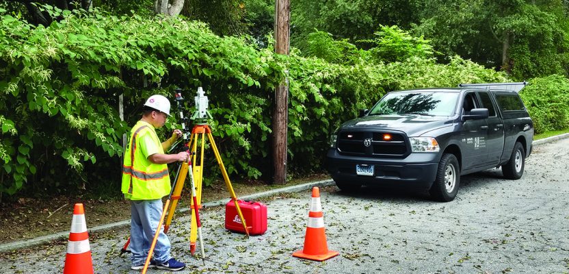
Above: A crew chief with BL Companies of Connecticut begins his day working with Captivate.
The evolution of 3D surveying field software and Leica Geosystems’ Captivate might surprise you.
Editor’s Note: Captivate has been widely implemented among Leica Geosystems users for several years now. In many ways it was a dramatic leap for Leica Geosystems—going fully 3D in surveying field data collection software—that not all users implemented right away. Users we have spoken to report that moving to Captivate was a breath of fresh air. However, some users of legacy gear and software are still apprehensive about moving to Captivate and asked us to take a fresh look at the software.
Modernization leads to many downstream improvements. This is as true for surveying instruments and software as it is for more widely used technologies of the information age. Microsoft Windows 3.0 was introduced in 1990, and 28 years later more than nine official Windows versions have been released.
Every few years we all must relearn and adapt to the new functions and features that the latest versions of Windows, iOS, Android, etc. offer. Some of the releases are short-lived, but without the courageous engineers willing to try new ideas, we wouldn’t have the same platforms we have today.
In order to provide the latest feature and function from next-generation hardware, in some situations the software platform needs to undergo a complete redesign. For example, when Intel improved its CPU from 16bits to 32bits in 1985, the entire Windows programming and all the third-party applications needed to adapt. This cycle repeated when the 64bit CPU was introduced to the market, which caused another disruption to the entire industry.
In the land surveying world, we are experiencing the same kind of evolution. When the theodolite was enhanced with a simple program and became a total station, the onboard software was in the same situation as Windows.
Surveyors started by asking for the ability to store observation data on a total station; years later, surveyors demanded GNSS instead of just GPS in its real-time processing using a data logger. These were the changes we shaped.
When 3D visualization became the buzzword, surveyors knew that’s exactly what you wanted next. Thus, a new generation of the onboard platform needed to be created to handle the latest needs from the market.
Onboard Software Evolution
We spoke with some of the SmartWorx team at Leica Geosystems back in 2005, when SmartWorx was the new face and brain for Leica Geosystems’ System 1200 total stations and GPS receivers. One of the key features was that it could run many applications instead of just single ones, like in the earlier primitive data loggers of various makes and models. You could load Volume Calculation, DTM Stakeout, Road Alignment, and many others. The SmartWorx team was eager to add more applications that could help surveyors save time in the field.
The result was a great system that users widely adopted, and the reliable 1200 series gained a solid reputation. It was no surprise that the ability to run multiple applications would run into limitations on available memory. (Nowadays, we all run out of memory on our phone at some point because the files and applications keep getting bigger.)
The next-generation software and hardware was already in development. With new hardware to include a new CPU, processing board, and bigger memory, the SmartWorx Viva was able to offer much more. It had a new focus and design direction: the idea was to simplify the user experience by adding more wizards in each application. The first generation of SmartWorx was designed for a traditional land surveyor’s mindset, but not all users have gone through a four-year land survey-engineering program (in German-speaking countries, in contrast, the land survey engineering program is typically six years).
Luckily, SmartWorx Viva was on the path of, “Pick it up, turn it on, and start working immediately.”
Many total station and GPS users at a construction site just needed on-display instructions to get their job done, and, most importantly, the instructions must use non-technical terminology. At the Viva designing phase, the development team had to redesign all the icons for the higher-resolution color display. Without any rework on the icons, it would have looked like playing Pac Man on HD TV—hideous. We had heard that, for a while, icon redesign was someone’s full-time job.
First Contact
The smartphone has been making the greatest impact to our lives in the past ten years, and as users who work on a touch-display instrument, we tend to relate our experiences to how we use icon-based smartphones.
The xyHt team got a first-hand Captivate experience at HxGN LIVE2018. We tried the onboard software on a CS35 tablet. A first impression was, “This is how I use a regular tablet at home!” and we were even more impressed when we found out the tablet is only 5 grams (0.011lb) heavier than a handheld CS20 controller. You aren’t limited to the tablet (although the extra screen area can be advantageous); Captivate can run on the CS20 handheld controller alone.
Shane O’Regan is the expert who gave us an in-depth demo. He’s a product expert for Captivate, and this is his official title at Leica Geosystems.
We asked O’Regan, “What’s the designing philosophy for Captivate’s user’s experience?” He told us there are three elements.
First, the user experience. O’Regan said, “Building on the success of Leica Viva, we wanted Leica Captivate to be easy to use and feel discoverable by our customers. This makes it easier to get tasks done without feeling lost in a software and therefore more enjoyable to use. Leica Captivate is also customizable so you only need to see the jobs, applications, and settings that are important to you.”
Second, 3D everything. “As measurement professionals, we have always captured 3D data, but this is the first system to let you experience the power of that 3D data live in the field,” O’Regan said.
“It’s irrelevant if it’s from a design file like the now-supported IFC format or a finished survey. Leica Captivate fully supports the digitalization workflow from the field to the office.”
A highlight of the software is the 3D rendering ability to display captured data in a way that a user can overlay point clouds captured from a Leica Nova MS50/60 Multistation, georeferenced images, coding, and line work that is relevant to a user at the same time. We noted Captivate’s ability to show a tremendous amount of data without overfilling the display.
Third, back to basics. O’Regan said, “We wanted Leica Captivate to have a simplified workflow to make it easier and quicker to complete the work in the field, whether it’s creating a job, or coding of points and lines. Also, the enhanced linework and multi coding options in the field really enhance the field-to-finish workflow for many of our customers.”
We’ve had an opportunity since to further explore Captivate and discovered two additional noteworthy features.
There’s a fast response time when you touch any icon with a finger or stylus. (So many devices out there make you push the screen a couple of times before they react to your input.)
Also, we like using software when it’s similar to how we use Microsoft Windows or a smartphone. We were able to try out different icons (functions) on the display and find out what they do—if you don’t wish to continue you simply go back without making any changes.
There’s no real reason why surveying field gear should not operate like the familiar operating systems and interfaces that are ubiquitous in our daily lives—no more cryptic and clunky menus, please.
A Deep Look
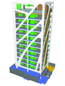
A 3D view of a building from a standard IFC (BIM) file. Captivate utilizes these natively for both layout and as-built verification.
Some users we spoke to thought they could teach themselves how to use Captivate in less than half an hour, but that was not always the case. But we think this is a good sign because without significant changes there wouldn’t be a newer and better workflow. The truth is, even though users might be an expert on the SmartWorx platform, the Captivate experience has shown how the Leica Geosystems field software has evolved quite a bit from the time of SmartWorx.
In our initial 50 minutes on Captivate, we found we could open an old job file from System 1200. We like this feature because we know that a lot of survey firms still have a mixed generation of survey equipment in their inventory, and some of the old total stations just keep going even after 15 years.
Later we found out that Captivate has the ability to connect older total stations, all the way back to System 1200. A lot of small-business customers really appreciate the fact that they don’t have to replace their entire equipment inventory all at once to be able to take advantage of Captivate.
Most of the time, the older total stations outlast their paired data logger. With Captivate’s backward compatibility, it can control any of these older Leica Geosystems total stations in an equipment fleet with the latest Captivate running on a CS20 or CS35. This setup enables users to open a much bigger file than before on the older total stations.
Captivate and BIM
The second interesting feature we found was the support for Industry Foundation Classes (IFC) files. As we keep writing about here, the construction industry is heading into a new digitalization era, and this file format is becoming increasingly popular with building information modeling (BIM) applications and surveyors. In Captivate, you can attach an IFC file to a job, and all the IFC classes are imported, as well.
In addition, a user can import points and lines from an IFC object by elements of interest or its geometry. This is exciting because, instead of loading multiple DXF files, you can simply load an IFC file with a lot more information.
The last cool thing we discovered is the ability to apply multi-coding on a point. I hear there’s really no good way to explain this value if you don’t use coding and linework and import/export files with these features frequently—you might want to explore these functions if you haven’t already. The ability to be able to easily assign multiple codes to one single measured point can save a lot of time; multiple points are later exported, each with an individual code.
Key to the new Captivate user environment and interfaces is full 3D, as shown in this IFC (BIM) object selection view.
Feedback
We spoke with Shannon Hixon of Boulder, Colorado about his and his customers’ experiences with the Captivate system. He’s the CEO of Hixon Mfg. & Supply Co., the largest Leica Geosystems dealer in Colorado and Wyoming.
We asked him what the main differences are between Captivate and the SmartWorx platform. He said that his customers definitely like the 3D view. We were curious if the 3D view can display enough details on the CS20 (5” screen).
“Surprisingly, it’s not an issue for those who prefer a handheld data logger,” he said.
Hixon also noted that another popular function for the North America region is the one-step and two-step coordinate transformation. This is not something new, but with Captivate you can more easily manage points in different coordinate systems.
The last big difference Hixon mentioned is the language display. You can change the entire language menu with three button-presses without restarting. This allows users who have different native tongues to share the same equipment easily.
“One of the wonderful things about Captivate is to view and rotate things in 3D. This gives me the ability to perform a QA/QC check on a new scanned dataset onsite,” said Donald Smith, a senior project manager and a professional surveyor at BL Companies in Connecticut. Smith and his team switched to Captivate about two and a half years ago.
When Smith explained how the linework and coding feature makes his job easier, he did so with a beaming smile. “The Captivate software platform has helped to streamline our services and minimize impacts previously experienced when changing from one type of collection and stakeout software to another.”
Another testimonial about the benefits of the progression from the 1200 series to Viva to Captivate is from Greg Maier, survey coordinator for the City of Kelowna in xyHt’s June 2018 feature, Full Tilt about the new GS 18T GNSS rover.
The Software You Shape
Hexagon, the parent company of Leica Geosystems, talks about shaping your industry. In one of the keynote speeches at HxGN LIVE 2018, Juergen Dold, president of Hexagon’s Geosystems Division, closes the presentation by saying, “You as our partners are the rule-setters. Please continue to provide us the valuable reality checks—those that help and those that hurt before they help.”
We are firm believers that in order to improve a product your feedback is critical. The theme of the HxGN LIVE 2018 was “The Change You Shape” (and that was even on the t-shirts attendees received).
The impetus of software like Captivate is to enable more realistic data—the capture of reality. Such software must serve your reality and that of your crews, and you can shape what that reality looks like. If you have a good idea for the Captivate team to add a new feature/function, you can send your valuable input to a local Leica Geosystems representative.