November 2018 Archives
Examining Captivate
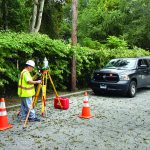
Above: A crew chief with BL Companies of Connecticut begins his day working with Captivate. The evolution of 3D surveying field software and Leica Geosystems’ Captivate might surprise you. Editor’s Note: Captivate has been widely implemented among Leica Geosystems users for several years now. In many ways it was a dramatic leap for Leica Geosystems—going […]
CA Wildfire Cleanup
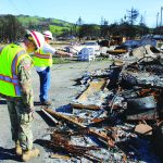
The U.S. Army Corps of Engineers, under the direction of FEMA and in partnership with the California Governor’s Office of Emergency Services, removed more than one million tons of fire-related debris. Credit: Carol Vernon, Public Affairs, Pittsburgh District, USACE. The U.S. Army Corps helps rebuild lives with GIS technology. In October of 2017, numerous, fast-moving […]
Lava Mapping
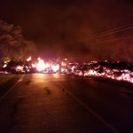
sUAS provide data for response to an unstoppable disaster. To most people living in Hawaii, it is not unusual to hear of an active lava event somewhere in the islands at any given time. Despite the nearly 70 earthquakes of magnitude 2.5 or stronger a week prior to the Kilauea lava event, it might have […]
Esri – Autodesk Partnership

Year one of a bold partnership—that the world of infrastructure really needed to happen. Geospatial Giants Esri president and co-founder Jack Dangermond and Autodesk CEO Andrew Anagnost both agreed to our interview request to provide insights on the Esri-Autodesk partnership, now entering its second year. Of course, they discussed the specific fruits of the collaboration […]
Street Views of the Water
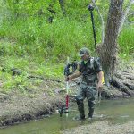
Above: Martin Offenhauer surveys the Big Rock Road section of the San Diego River. Credit: SDRPF. Mapping rivers above and below the surface creates great opportunity for engineers and stewards. The way maps are produced and displayed varies greatly, depending on their extent, their intended use, and the peculiar challenges of each environment. Mapping a […]
3D Straight Down
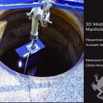
Seeing down manholes in detail is an innovation made possible with 3D scanning. [Above image: Deploying the camera system down a manhole to access the Hooksett, New Hampshire sewer system. No breaching of the hole happened, which is a serious OSHA consideration. (The GibbetMount shown here has a steel casing that’s since been upgraded to […]