From editor Scott Martin: The original purpose of this guest article by Michael McGee, PLS, et al, was to protect the integrity of this historical monument and its position, which were imperiled by plans to make improvements to the Washington Square Park. Michael and several others, including Dave Doyle, NGS retired geodetic surveyor, quickly researched the historical significance of this monument and the role it played in the critical coastal mapping program of one of the most important coastal cities in the United States regarding commerce. As surveyors, we are often the only ones who understand and appreciate the significance of these historical monuments, so we need to step up to educate and protect them whenever possible.
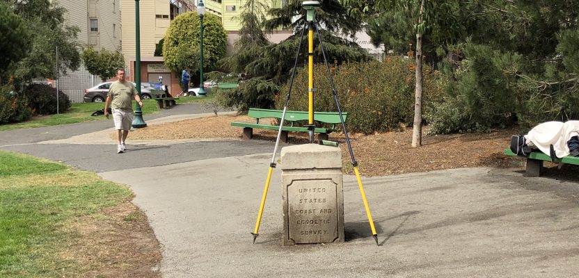
The National Geodetic Survey “ASTRONOMICAL MONUMENT” stands in San Francisco’s historic Washington Square Park in the North Beach District. Visitors to the park may be curious to know the significance of this mysterious object and its place in history with its 150-year-old markings.
This monument traces its origins to Dr. George Davidson, a geodesist, geographer, astronomer, surveyor, and engineer for the United States Coast Survey, which established the monument in 1869.
In 1807, the U.S. civilian scientific agency, the Survey of the Coast, was established to survey the U.S. coastlines for mapping the country and preparing nautical charts. This agency became the U.S. Coast and Geodetic Survey in 1878, predecessor to the National Geodetic Survey (NGS) under the National Oceanic and Atmospheric Administration in 1970.
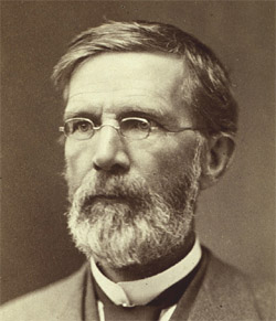
George Davidson (credit: NOAA Central Library)
In 1868, Davidson was promoted as head of field assistants of the U.S. Coast Survey, taking charge of surveying the Pacific Coast under superintendent Alexander Bache. The fieldwork conducted by Davidson and field assistants was “to make latitude, longitude, and azimuth at stations to support primary triangulation.”
In 1869, San Francisco was an integral part of the west coast regional survey when, according to the “Report of the Superintendent of the United States Coast Survey Showing the Progress of the Survey During the Year 1869,” Davidson was assigned to determine the difference of longitude and latitude between San Francisco and Cambridge Observatory, Massachusetts, by telegraph.
With permission from the mayor and supervisors of San Francisco, the Washington Square Park Astronomic Station was established for this purpose. The difference in longitude relative to other locations in the United States using the electric telegraph was determined, and the station was connected to the survey triangulation station on Telegraph Hill to support the triangulation network for mapping the western United States.
Recently, San Francisco’s Public Works Division of Surveys & Mapping (under the direction of Bruce Storrs, City and County surveyor) learned of planned changes to the park that may have resulted in the monument being moved or removed. They rallied to gather information on the historical significance of the monument and the position in order to convince the City not to disturb it.
Now the Washington Square Park Astronomic Monument is a permanent part of San Francisco historical legacy that played a prominent role in these geodetic survey efforts to map the western United States and the Pacific Coast.
This astronomic station is in the NGS’s database of monuments, listed as PID HT0732. Previous NGS database entries date from 1869, 1870, 1880, 1952, 1969, and 1988, all reporting the status of the station as being in good condition.
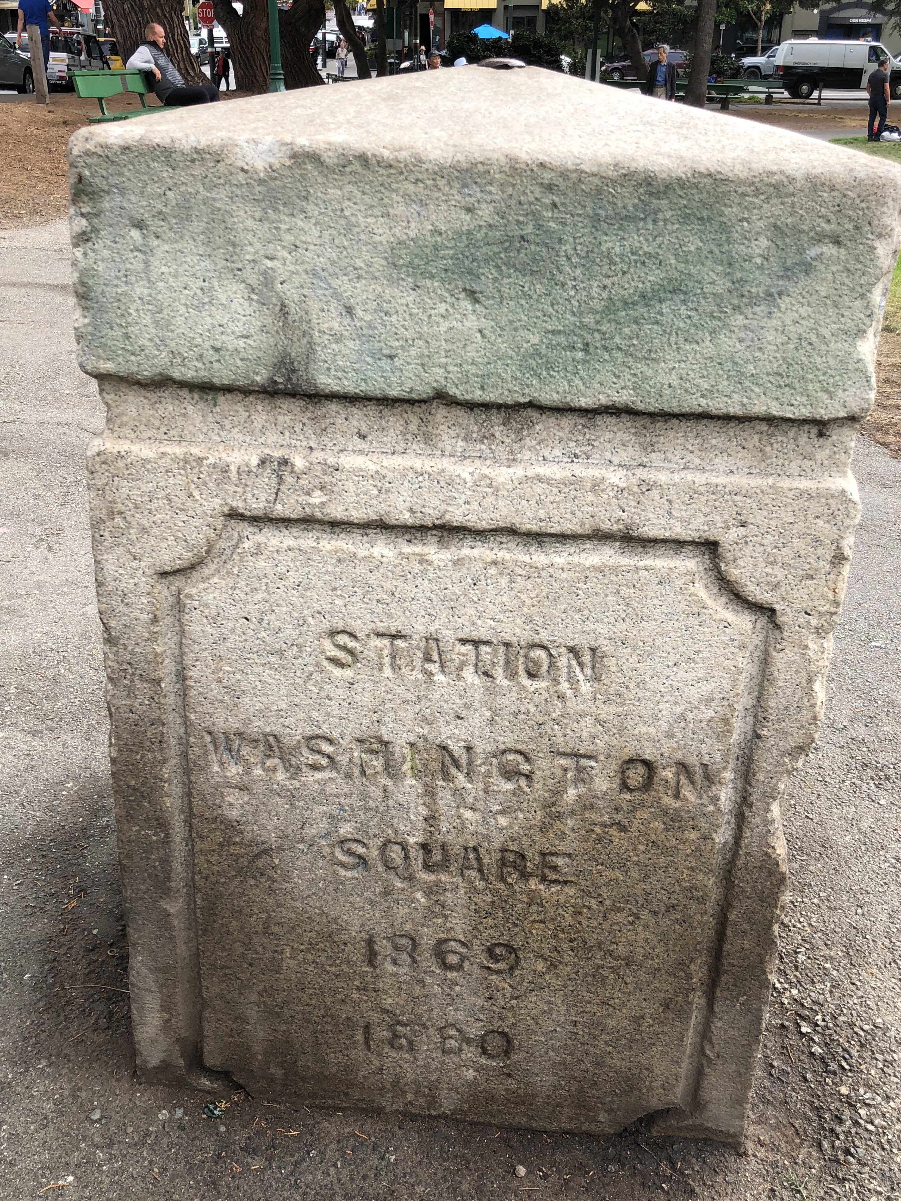
“1869 San Francisco Astronomic Station” in Washington Square Park is also referred to as the “Electric Telegraph Longitude Station.”
The physical description of the monument is a “bolt established on top of a light structure.” The “light structure” is described as a 2’ x 2’ x 3’ high concrete block with an 8” granite cap. Each of the four sides are imprinted as follows: “U.S. Coast and Geodetic Survey,” “Latitude 37°47’57″N Longitude 122°24’37″W,” “Station Washington Square 1869, 1880,” and “Astronomical and Telegraph Longitude.”
The astronomic station became a vertical bench mark during the mid-1900s, referencing the National Geodetic Vertical Datum of 1929.
Dave Doyle, retired chief geodetic surveyor of the NGS, noted that the change in the reference meridian at Greenwich has an impact on today’s longitude. Doyle reviewed the USC&GS Special Publication #110 (it includes the descriptions of all the old astronomical stations by state) and resolved the U.S. Standard Datum/North American Datum geodetic position to N 37°48’04.721” & W 122°24’31.515”. Using the NGS Coordinate Conversion and Transformation Tool (NCAT), he determined the transformed NAD83 (2011) Epoch 2010.00 coordinate to be N 37°48’03.397” & W 122°24’34.191”. Listed below are the tabulated values as noted.
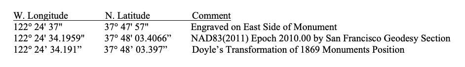
The above difference between the historical latitude and longitude and today’s position determined with GNSS methods is 1 foot N-S and ½ foot E-W.
Doyle said, “The work that those early Coast surveyors performed was nothing short of awesome. They worked extremely long days and accepted results that were as perfect as the times, conditions, and instrumentation allowed.” We agree and stand in awe of those who came before us.
This comparison is also an excellent example of how high-accuracy geodetic coordinates can be a valuable attribute even after more than 100 years, provided they are accompanied by the appropriate metadata.
This article was composed from the contributions of several individuals under the authority of Bruce Storrs, City & County Surveyor of San Francisco.
References
- Davenport, B. Charles. “Biographical Memoir of George Davidson.” Academy at the Annual Meeting. Washington D.C.: National Academy of Sciences of the United States of America Biographical Memoirs, 1937. 189-217. Memoir.
- FoundS. “Washington Square: Historical Essay.” 2000. Found SF. Article. 23 August 2018.
- Geocaching. Details for Benchmark: HT0732: Geocaching. 11 10 1988. Webpage. 23 August 2018.
- National Geodetic Survey. Datasheet 95, Version 8.12.5. Data Report. Silver Spring: National Geodetic Survey, 1988. Datasheet. 23 August 2018. <https://www.ngs.noaa.gov/cgi-bin/ds_mark.prl?PidBox=HT0732>.
- Sarah Beal. U.S. Coast and Geodetic Survey, Special Publication 110 “Astronomic Determinations”: 1925 <ftp://ftp.library.noaa.gov/docs.lib/htdocs/rescue/cgs_specpubs/QB275U35no1101925.pdf>
- Pierce, Benjamin. Report of the Superintendent of the United States Coast Survey Showing the Progress of the Survey During the Year 1869. Annual Report. Washington D.C.: Washington: Government Printing Office, 1872. Document. 23 08 2018.
- —. Report of the Superintendent of the United States Coast Survey Showing the Progress of the Survey During the Year 1870. Annual Report. Washington D.C.: Washington: Government Printing Office, 1873. Document. 23 08 2018.
- —. Report of the Superintendent of the United States Coast Survey Showing the Progress of the Survey during the Year 1871. Annual Report. Washington D.C.: Washington: Government Printing Office, 1874. Document. 23 08 2018.
- —. Report of the Superintendent of the United States Coast Survey Showing the Progress of the Survey during the Year 1873. Annual Report. Washington D.C.: Washington: Government Printing Office, 1875. Document. 23 08 2018