Surveying the Arsenal Interlocking rail corridor in Philadelphia safely and efficiently with mobile lidar.
An old section of the Pennsylvania railroad called the Arsenal Interlocking is now one of the busiest segments of rail for the Southeastern Pennsylvania Transit Authority (Septa) regional rail system. A high volume of trains operates in this territory due to the confluence of rail lines used by Septa, Amtrak, and various freight rail operators. Septa needed a seven-mile stretch of this busy rail line (from 30th Street Station south through University City) to be surveyed, and conventional means were not an option.
With limited access to the tracks and dangerous working conditions due to the high volume of trains, conventional surveying would have been an arduous task that the schedule couldn’t afford. A solution came when Maser Consulting, P.A. of Red Bank, New Jersey, in cooperation with HNTB Engineering of Kansas City, Missouri, implemented mobile lidar scanning. The mobile mapping approach expedited the project and gave HNTB designers accurate and rich data to work from.
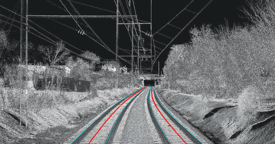
This mobile lidar data is of the extracted top of rail and centerline.
Field Operations
The Maser Consulting geopspatial team, lead by lidar manager, Clay Wygant, employed their Riegl VMX-450 mobile lidar scanning system mounted to a hi-rail pick-up truck. The VMX-450 scanning system uses a GNSS and inertial measurement system providing an accurate vehicle trajectory path. Two tightly integrated laser scanners acquire up to 1 million individual measurement points per second.
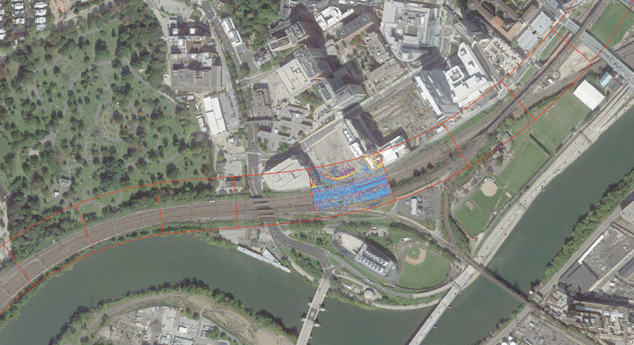
Cloud storage provided users access to Arsenal project data across operations.
Collectively, this data creates a point cloud, essentially a 3D spatial image of the rail corridor. The point cloud data can be supplemented with color digital images from as many as six calibrated digital cameras. These images are aligned precisely to the point cloud data. The resulting system data set is rich in spatial information necessary to identify, locate, and extract features, measurements, models, and topographies.
The team began the Arsenal project by establishing a network of control survey coordinates along the rail corridor by using traditional survey technologies. These reference coordinates were located approximately every 500 feet on opposite sides of the corridor and are used in post-processing operations to improve the trajectory and overall system data accuracy. Properly executed processing operations will typically result in overall system data accuracy within the specifications of the control coordinate network.
Establishing the network control survey coordinates along the seven-mile corridor required several weeks and was the only segment of the project to employ traditional survey technology.
Having established the reference control network, the team employed their mobile lidar scanning system to acquire the corridor data in a single overnight session along the entire corridor. The speed and efficiency of the team’s field operations on the Arsenal project are orders of magnitude higher than traditional survey methods.
While data acquisition speed is a key contributor to overall project productivity, the safety aspect of mobile lidar scanning systems should be noted as well. In order to maintain a safe operation, control was established during overnight, non-revenue hours. Data acquisition by the team’s mobile lidar scanning system was accomplished at speeds of approximately 25 mph, keeping track time requirements extremely low. Therefore, both operations required minimal track access and consequent exposure to potentially hazardous conditions.
Data Management and Organization
The team estimates that the Arsenal project acquired 12 GB of point cloud data. Handling such large amounts of data from field to office poses challenges in storage, transfer, access, and sharing, both internally at Maser Consulting and with external partners such as HNTB Engineering. The team used TopoDOT, a MicroStation point cloud processing software application (offered by Certainty 3D) to address these challenges effectively and economically.
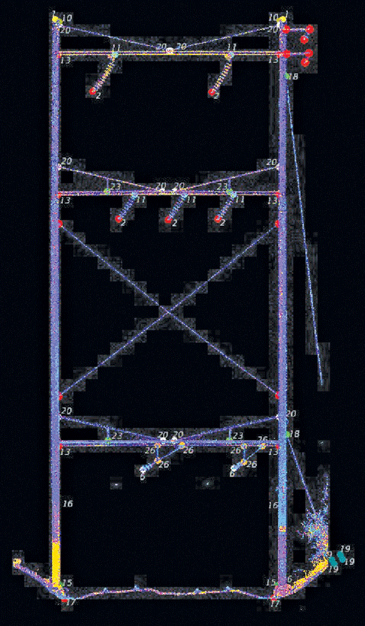
A slice of mobile lidar data was used to extract key points on the overhead catenary structures.
The team used TopoDOT’s data management tool suite to automatically lay out tiles located along the Arsenal project corridor. Having established the appropriate tile dimensions, TopoDOT then automatically subdivided the large point cloud files into smaller files containing data located within the corresponding tile. It also created and located a link icon within each tile serving as direct access to that specific tile data.
The result is a very simple and “light” set of data access icons geospatially located along the corridor. A simple click on one or more of the icons loads the corresponding point cloud data from the storage medium to the user’s workstation.
The team used the Amazon cloud as the primary storage medium for sharing Arsenal data with the internal processing team and with partners. TopoCloud was used for overall data administration.
Thus, Maser Consulting’s processing professionals were able to download the geospatial icons associated with the Arsenal project and download the specific data of interest where and when they needed it. Moreover, by restricting access to Arsenal data to a single storage medium, they were able to maintain quality control over the Arsenal data.
Feature and Model Extraction
Maser Consulting’s processing team coordinated their extraction operations by assigning specific corridor segments and/or features to individual technicians, thereby effecting a parallel processing operation. Processing technicians employed their TopoCloud tools to access and load assigned data where and when it was needed.
Each technician employed a tool suite to extract a topographic map comprised of CAD elements and models representing features required by HNTB and SEPTA. TopoDOT’s profile extraction tool was employed to automatically extract the top of rail feature from the point cloud data.
Automated roadway tools were applied to ballast extraction, producing accurate ballast topographies quickly. Cross section and break line extraction tools exploited the synergy between point cloud and calibrated images to extract more complex structures such as retaining walls, station platforms, canopies, etc. Elevation drawings for overhead catenaries were extracted along with key attachment points for all appurtenances. The technical team also included a corresponding cross section of raw point cloud data at each catenary structure as a general reference of existing conditions.
The Arsenal project serves as an example of the effective application of mobile lidar laser scanning technology to a highly active rail corridor survey. Maser Consulting’s survey professionals have demonstrated that such significant increases in productivity and deliverable quality rely not only on the selected equipment and software, but also on the complete organization of the team around this technology. In this case, the resulting field-to-finish workflows increased field safety, deliverable quality, and overall productivity such that the Arsenal seven-mile corridor survey was completed in only three months.
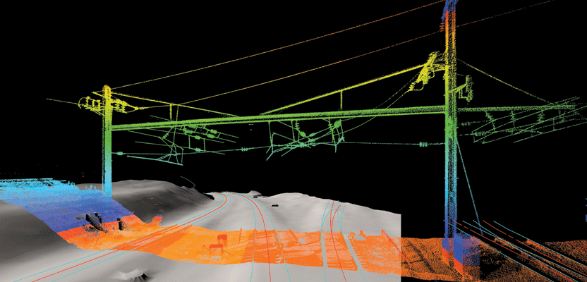
These high-quality 3D CAD models were extracted from Arsenal project point cloud data.