Could a Pittsburgh-based start-up help improve (and save) America’s bridges?
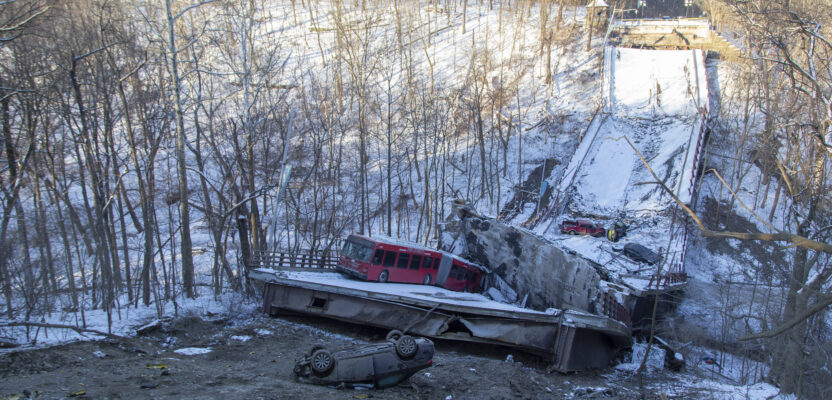
Early in the morning of January 28, 2022, a Pittsburgh Regional Transit Authority bus crossing the Fern Hollow Bridge began bouncing and shaking for no apparent reason. Moments later it plummeted into a ravine along with several other vehicles as the bridge collapsed beneath them. Ten were injured but there were no fatalities, largely due to the light early morning traffic. An hour later it could have been a different story as the bridge is crossed by commuters and many school buses.
Still, the collapse sent shockwaves throughout the construction industry, unsettling industry pros and government officials.
The 49-year-old bridge’s catastrophic failure, the cause of which is still being investigated by the National Transportation Safety Board, also prompted a group of Carnegie Mellon University graduates to start to devise a way to accurately map the nation’s terribly aging infrastructure.
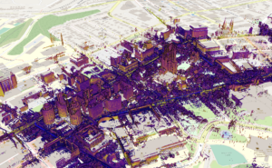
So was born Mach9 Robotics, a tech firm whose pilot demonstration is mapping 450 bridges in the Steel City. Using ground and aerial vehicles to capture infrastructure conditions, Mach9 is blending visual, spatial, inertial, GPS, and radar data to create high-definition maps of infrastructure, which are partly intended for predictive analytics.
The Fern Hollow bridge in Pittsburgh, PA, shortly after it collapsed in January 2022. Credit: National Transportation Safety Board
Named after the NASA X-43 aircraft, which set airspeed records by flying at Mach 9.6, the firm is comprised of a team of 15 designers, engineers, and business developers.
“Our mission is to enable computers to see and understand the world faster than humanly capable, perhaps even faster than the X-43,” said Mach9 co-founder Alexander Baikovitz.
Mach9 has built its own 3D mapping and geospatial software and is scaling the platform with the help of various surveying, civil engineering, and utility services firms.
“The Pittsburgh Bridge Initiative has helped us refine our mapping technology to provide our commercial and government customers with robust, accurate, and fast insights from the built world,” said Baikovitz. “We’re excited to be using Pittsburgh as a case study for the future of cities.”
The company was conceived to build technology to prevent infrastructure failures.
“Knowing how our technology can be applied to bridges and seeing the Fern Hollow Bridge collapse not far from our office and where we went to college, we wanted to fix our country’s degrading bridge problem and launched the Pittsburgh Bridge Initiative,” Baikovitz said.
Monumental Problem
The difficulties of the nation’s worn infrastructure are widespread and grave. According to the American Society of Civil Engineers’ “Report Card For America’s Infrastructure,” 42 percent of the more than 617,000 bridges in the U.S. are at least 50 years old. More than 46,000 of the nation’s bridges (7.5 percent) are structurally deficient.

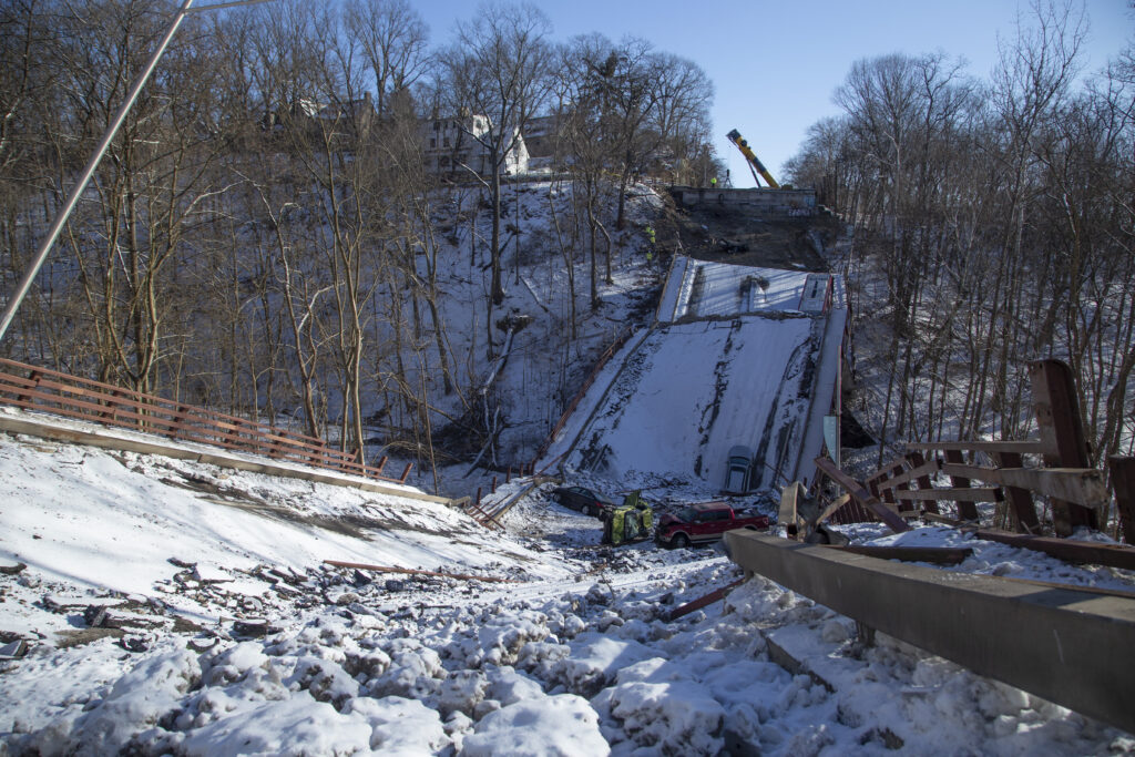
The Fern Hollow bridge in Pittsburgh, PA, three weeks before its collapse.
According to ASCE, the average age of the nation’s bridges is 44 years old. Despite that fact, the rate of improvement of the nation’s bridges has actually slowed.
“A recent estimate for the nation’s backlog of bridge repair needs is $125 billion. We need to increase spending on bridge rehabilitation from $14.4 billion to $22.7 billion annually, or by 58 percent if we are to improve the conditions,” the ASCE report states. “At the current rate of investment, it will take until 2071 to make all the repairs that are currently necessary, and the additional deterioration over the next 50 years will become overwhelming. The nation needs a systemic program for bridge preservation like that embraced by many states, whereby existing deterioration is prioritized, and the focus is on preventative maintenance.”
With a problem so massive, the solution will need to be both powerful, and subtle. It will require a layered approach with real-time functionality, providing living maps that always reflect the current state of the structure. Mach9 is planning on that, and more. The effort seems promising for the future of reality capture.
“The infrastructure assessment problem is much greater than creating 3D models and renderings. We’re working to provide solutions to make reality capture data more actionable, and to help decision makers understand the health of their infrastructure,” Baikovitz said.
Mach9 is working on so-called “living” documents that represent the actual states of the bridges they’re mapping, but even the construction industry, in general, is often behind in fully utilizing tech tools they employ on projects, to say nothing of the backwardness of operations in many local governments. So, how confident is Mach9 that local officials will make full use of these up-to-date documents they’re providing? Very confident, because they’re partnering with their users in developing the platform.
“We’re working to build purposeful technology by collaborating with engineering firms, DOTs, and municipalities to extract actionable information from geospatial data that will boost organizational efficiency and help leaders make data-driven decisions for the safety of their communities” Baikovitz said.
 This new tech tool may, in some cases, obviate the need for so-called “as-built” documents, which often seem to not fully reflect the state of the asset, creating their own sets of problems. Mach9’s staff has experience in underground utility infrastructure and knows the pitfalls of relying on sometimes sketchy as-built drawings.
“We’ve learned by working with different utilities and municipalities across the world that as-built documents are sometimes inaccurate and outdated,” Baikovitz said.
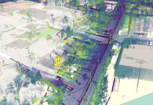
Mach 9 scans of Pittsburgh neighborhoods Squirrel Hill and Oakland show egress and ingress into residential areas along interstate 376 and its many bridges.
But how will Mach9 ensure these documents are easily and consistently updated to reflect the structure in its present state? They’ll be using the Cloud for part of it, of course.
“Unfortunately, as-builts are often overthought in new construction and are often difficult to manage as facilities change. The Mach9 Infraverse has been helping utilities and facilities more affordably manage their infrastructure using living maps on the Internet,” Baikovitz said.
Mach9 Robotics has raised $2.5 million and is backed by venture capital firms including Tiger Global Capital Management, Soma Capital, Liquid 2 Ventures, Quiet Capital, Y Combinator, and also by angel investors, including James Park (former CEO of Fitbit) and Bruce Gebhardt (a member of Mach9’s board of directors and former managing director at Bank of America). The startup also is funded by different government agencies.
Collaborative Effort
The question of how this fledgling tech firm will make reality capture both more accessible to users and more powerful is a work in progress, with many hands contributing to its progress.
Mach9 is automating inspection and GIS mapping by building intelligent data analytics tools for understanding large-scale maps. It’s a corporate collaborative effort that’s already bearing fruit for its partners.
“Working with utility and engineering partnering companies, Mach9 already has expanded the number and types of problems they’re able to solve with mapping tech. Partnering companies have seen an over 75 percent time savings using Mach9’s platform,” Baikovitz said.
Some tech platforms require a fair amount of employee training from the software company and take a month or more for a company-wide adoption of the platform. This obstacle of training can be one of the pitfalls holding a company back from making the most of the newly adopted tool. Along with that, an incomplete understanding of how to use the platform often limits its effectiveness. Mach9 plans to be easy to adopt.
The technology the company has been working on fits directly into existing inspection processes, and it doesn’t need huge changes or substantial training for organizations to adopt, Mach9 officials say.
“Technology should address pressing problems and not invent new ones. We think building intuitive user experiences with intelligent analysis capabilities will help us empower the existing workforce without substantial amounts of training,” Baikovitz said.