CASE STUDY
CompassData Ground Control Ensures Accuracy of Digital Aviation Maps
Aviation mapping is rapidly transitioning from paper to digital, and CompassData is working hard to ensure the new maps are better than their predecessors. In just the past two years, CompassData crews have collected high-accuracy, globally consistent ground control points (GCPs) and generated satellite-derived orthoimages at hundreds of airports worldwide for use in creating a variety of digital map products.
In many cockpits, the traditional paper navigation charts and sectionals have been replaced by digital displays and tablet computers. As the concept of the fully digital flight deck becomes reality, commercial airliners may be equipped with realistic 3D displays of airports and their airspaces with real-time weather and traffic inputs, allowing pilots to safely navigate in the air and on the ground. To support these and other efforts, the FAA and international counterparts are promoting the development of digital map databases for aerodromes around the world.
Not surprisingly, satellite imagery and aerial photography are playing critical roles in these mapping initiatives. As is true with any cartographic products derived from remotely sensed data, the accuracy of the produced maps depends on the quality of the GCPs used to process and rectify them. And because airplanes usually travel from one location to another, airport maps – and GCPs – must be consistent worldwide.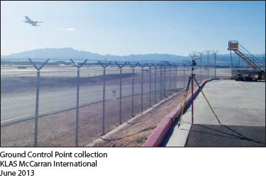 “In aviation mapping, accuracy and consistency mean safety,” said Hayden Howard, CompassData Vice President.
Over the past 20 years, CompassData has developed standardized methods of collecting and processing GPS ground control that ensure every point is consistent regardless of where it was captured. Used in diverse GIS and photogrammetric applications, every GCP collected by a CompassData crew or one of its carefully trained partners meets or surpasses rigorous accuracy and quality standards.
According to Howard, the procedures they use to survey control points for airport projects are identical to any other type of mapping project. The only difference is the number of points collected. Depending on the specifications of the client and size of the airport, most projects have involved between five and 20 GCPs. All of the points are photo-identifiable and are typically surveyed on the airport property. In some cases, however, collection occurs in the area surrounding the facility.
“We verified most of our GCPs at 10 centimeters or better,” said Howard.
To date, CompassData has collected GCPs for 435 airports in North and South America, Africa, Europe, Asia and Australia. Although collected at the request of specific clients, CompassData has retained rights to the GCPs and stored them in its commercial archive of points available for off-the-shelf delivery. Each GCP is delivered with accompanying metadata, ground photo, survey equipment used and station diagram.
CompassData is in the process of working with the FAA to receive a Type 1, LOA for DO200A certification as a provider of ground control and orthorectified imagery. With final receipt of the LOA, CompassData will be positioned to provide ground control and imagery to suppliers of aviation mapping product per DO272 for AMDB and Obstruction product development.
CompassData imagery and control will enable providers to develop mapping products at 1- and 5-meter accuracy with the traceability required to meet FAA, NGA and RTCA requirements.
“For custom collects at airports, we typically had a delivery turnaround time of two to four weeks for U.S. jobs and four to six weeks internationally,” said Howard.
For nearly a quarter of the airports where GCPs were collected, clients took advantage of the in-house orthorectification service established by CompassData last year. As field crews were surveying GCPs at the airport sites, CompassData leveraged its role as a multi-source satellite imagery reseller to obtain the appropriate WorldView-1, WorldView-2 and GeoEye-1 image data from DigitalGlobe and Pleiades data from Astrium (Airbus) over the area of interest. Using BAE GXP software, CompassData professionals orthorectified the image with the high-accuracy GCPs from the field.
“In the orthorectification process, we used most of the GCPs but kept a few for accuracy verification purposes,” said Howard. “For some airport clients, we provided three distinct services – GCP collection, orthorectification, and orthoimage accuracy verification.”
CompassData has retained orthoimagery for 125 airports worldwide in its archive for commercial sale. These products can be used to generate multiple photogrammetric mapping products, including extraction of vertical obstructions. The GCP collection and orthorectification projects completed to date have involved major airports as well as smaller business jet facilities around relatively large cities.
At 26,000 points and counting, the CompassData GCP archive is the largest commercially available database of photo-identifiable points in the world. Clients may view the points in reduced-accuracy formats online at www.compassdatainc.com before ordering and downloading. The standard delivery format is WGS84, however, CompassData is able to transform any archived points to a specified datum, projection and epoch.
 CORPORATE PROFILE
CompassData is a worldwide provider of high-quality Ground Control Points (GCP) and field data collection services for GIS, photogrammetric and remote sensing applications.
Established in 2003 as a woman-owned small business, CompassData has developed standardized methods of collecting and processing GPS ground control that ensure every point is globally consistent regardless of where it was captured. Every GCP meets or surpasses rigorous standards for quality and accuracy.
CompassData performs custom collection of ground control and data sets for clients worldwide through highly experienced in-house geodetic survey teams and an international network of select partners. GCPs can be captured and delivered with guaranteed quality anywhere in the world within two to four weeks of order placement
Off-the-shelf GCPs are available for immediate purchase from the CompassData online database, the world’s largest commercial GCP archive containing over 26,000 photo-identifiable points in 100 countries. CompassData makes the GCP data and metadata available for viewing and direct download in a reduced-accuracy format from its website to enable clients to review points and license details before ordering the final data in the accuracy level required.
Used extensively to orthorectify or correct aerial, satellite and UAS imagery as well as LiDAR data, CompassData GCPs are utilized to verify the accuracy of imagery, LiDAR and GIS datasets. Remote sensing satellite operators also use GCPs to calibrate newly deployed sensors. CompassData routinely provides archived and new GCPs to gas and electric utilities, energy exploration companies, government offices, geospatial product vendors, and telecommunications organizations. Each GCP is processed to CompassData accuracy specifications and delivered with accompanying metadata and station diagram/photos describing how it was acquired.
The standard delivery format is WGS84, and CompassData offers optional deliveries in any datum, projection and epoch required by the client.
CompassData Inc.
12353 E. Easter Ave.
Centennial, CO 80112
Phone: (303) 627-4058
www.compassdatainc.com